

cspwal
-
Posts
3,134 -
Joined
-
Last visited
-
Days Won
3
Content Type
Profiles
Forums
Events
Posts posted by cspwal
-
-
Are you sure backwards wouldn't be having helicopter service to downtown from a HSR station outside beltway 8?
-
I have noticed that Sundance seems to miss a lot of movies - not as large of a selection. Granted it is also a smaller theater so that might have more to do with it
-
Thus the need for the Uptown line and better connections with the rest of the city. And I'm sure the 290 construction will be done by then
-
I think that is the way to think of it - in 30 years it won't be advertised as "minutes away from downtown" it will be advertised "in Houston's trendy North Uptown neighborhood"
-
 Truly a jewel we cannot live without!
yeah the only thing that sounded super important historically was the archaeological site - which I couldn't find any information about (using a quick 3 minute google search)
-
 2
2
-
-
For the Washington Ave corridor, the report identified Environmental Impacts to:
- National Historic District Heights Boulevard Esplanade (https://www.google.com/maps/@29.7717105,-95.397202,3a,75y,207.98h,84.3t/data=!3m6!1e1!3m4!1s8cJ8b_pQL7I4PAwynWYp3g!2e0!7i13312!8i6656 - they'd have to create an elevated crossing or an underpass, disrupting the historic median https://www.houstontx.gov/planning/HistoricPres/HistoricPreservationManual/historic_districts/heights_history.html)
- US Healthworks Hospital (https://www.google.com/maps/place/U.S.+HealthWorks+Medical+Group/@29.7947347,-95.4501751,17z/data=!4m5!1m2!2m1!1sUS+Healthworks+Hospital!3m1!1s0x0000000000000000:0x89ef9847eb343859- I assume having to demolish it)
- Houston and Texas Central Railroad archaeology site (not sure what this is)
- Cottage Grove Park (https://www.google.com/maps/place/Cottage+Grove+Park/@29.7783155,-95.4244988,17.46z/data=!4m2!3m1!1s0x0:0xaf158f812431e5ef - it already has a train going by it but a new HSR would probably have to eat up some of the park's land.
also, the FRA noted:
Additionally, DH‐1 also has a potential to disproportionately impact minority populations.
-
1
-
-
Wasn't that what the Intermodal station was going to be at UH-D? Move buses and Amtrak to a new building co-located with UH-D? Or am I remembering wrong?
-
The FRA report (https://www.fra.dot.gov/eLib/Details/L17203) is certainly a thick read, but I would recommend at least skimming it if you're intested in this project.
What I can gather from it, TCR had downtown as their goal, but needed to study if the costs of continuing into downtown were worth it compared to the increased revenue. From it being eliminated in level 1 screening, they used "the Project’s purpose and need, alignment objectives and design guidelines as screening criteria."
The two downtown alternatives failed on Economic criteria and Environmental criteria
Two alternatives for the Downtown Houston geographic group, DH‐1 and DH‐2, have potential to create significant environmental impacts, thereby resulting in higher per mile costs (TCR’s Last Mile Analysis Report 2015a). Given the cost to build the Downtown Houston potential route alternatives, they do not meet the economic viability of the Project purpose and need. Accordingly, FRA eliminated DH‐1 and DH‐ 2 from further consideration for this Project.
The discussion of why is on page 22 of the report.
-
1
-
-
Also, the train should be much faster than driving and might be faster than flying (that will depend on how fast you can realistically get from entering the station to the train leaving)
-
Yeah the NW mall is just the piece of land. Once they buy it, they'll demolish it, and build their terminal and depot. Parking garages, rental car lots, and most likely a new bus transit center (if Metro helps out) will be built, and it will completely change the fabric of that area.
What we really need though is to ensure that a light rail & BRT station is also a part of this development, and I think we need to figure out a way to push Metro hard to get this done. With out pressure, I could see them just building a bus shelter and sending a couple of local metro buses there like they do with Hobby
-
2
-
-
The building behind Sakowitz is so ... blank
-
Are they doing something different with floors 2 & 3 than on the other Sky House?
-
2
-
-
The no came in the first level of screening in the document - it seemed to me (someone with more experience in these kinds of things can correct me) that TCR gave them the financial cost and benefits of bringing it downtown, and that the environmental review found the costs of that, and it was a simple is Benefit > Cost? No? Ok this is elimated. It didn't even go into the more detailed analysis of the 2nd and 3rd levels.
-
1
-
-
It makes it look like a flag pole from this angle. And the building looks like it's flapping in the wind
-
2
-
-
No the food trucks pay the homeless people to bring food to people
-
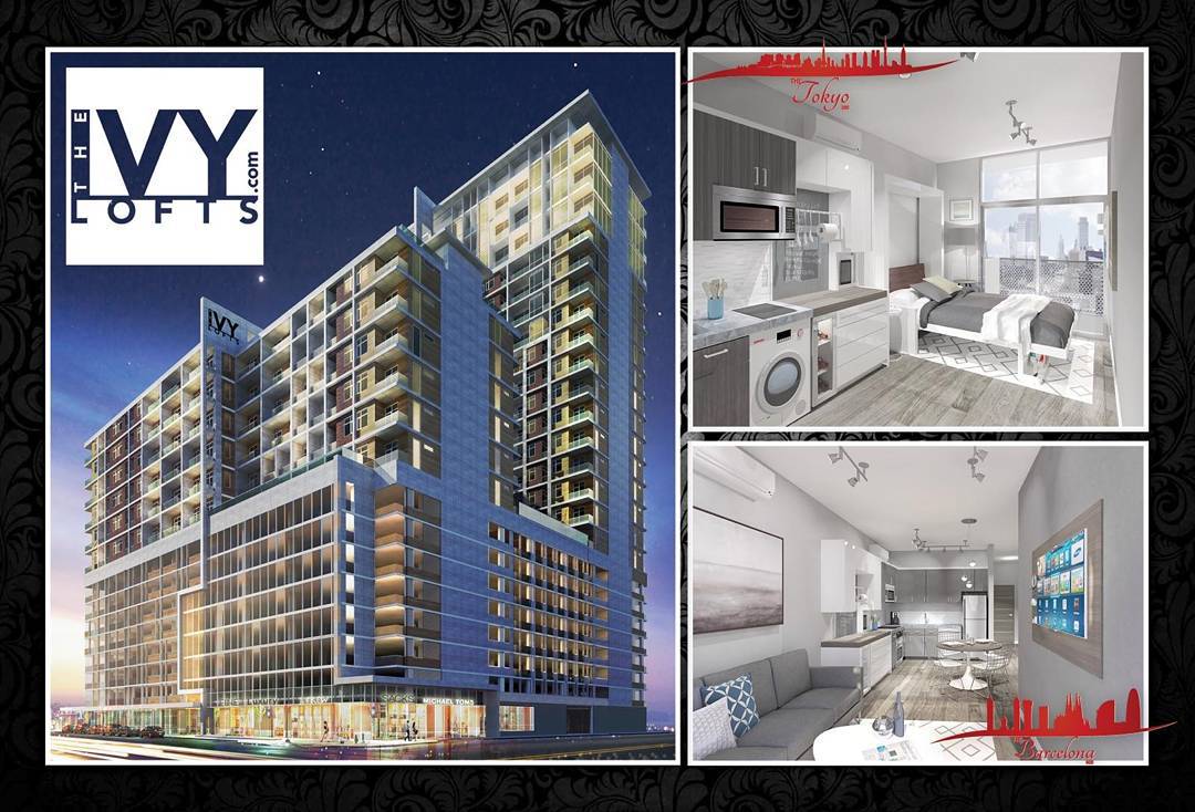
I like this render better - looks really nice. I see how they'll sell these - no one wants to buy a tiny condo, but people will want to buy "The Tokyo" or the "The Barcelona" I could even see with decorating the interior with nightlife scenes, landscapes, etc of the appropriate city.
-
I like the Heights Corridor routing. I could see it constructed as a partial express line to TCR if it followed the Heights Hike and Bike trail underneath Shepherd and Durham, through the Eureka yard to Hempstead Rd. It would appease any NIMBYs who may not want light rail going down W 11th and may allow for the train to attain higher speeds on those stretches where its grade separated going underneath those roads. Though I don't know if going 66 mph next to a Hike and Bike trail is a good idea.
That's why I put 25 minutes for the heights route - I assumed it would be going more like 30 around the that trail and on streets. I didn't even think of going through that yard - just looked at current ROWs. IT, I think we were both talking about it being a light rail not the HSR - light rail has more benefits to areas it goes through than the HSR because of more common stations
To be clear - I would prefer it to terminate downtown, but if it can't we should figure out how to tie in downtown/med center/everything else into the NW mall site
-
If they're anything like Skyhouse, they would leave the current pavement on the ground, and not repave until the end of the project
-
Such a huge site
-
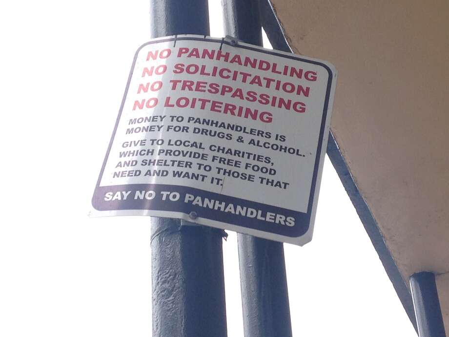
It looks like in the lead up to the opening of Frank's Pizza Tower, they want to limit panhandling
http://www.chron.com/houston/article/Downtown-signs-claim-giving-money-to-panhandlers-6627737.php
I haven't noticed these signs in person so I can't say how real they are, but the picture it looks like its card stock
-
1
-
-
Apparently TCR thought, and the Feds agreed, that the benefits of going downtown outweigh the environmental impacts to the neighborhoods and the cost of building it out.
I was thinking about how you could tie in this station into the light rail network, mainly to get people downtown, and I came up with 3 routes
West Segment by Christopher Hisle, on FlickrEast Segment by Christopher Hisle, on FlickrHere is the three lines in an interactive map:
(I couldn't figure out how to embded it)
Purple is an extension of the purple line going west from downtown, following Houston Avenue to Washington Avenue, and then following Washington Avenue all the way to Hempsted Road, where it goes to NW Mall.
This line I think would be both the most useful and would face the most intense opposition as well as the hardest to construct. It only requires one new overpass (right where Hempsted and Washington Ave intersect) and would connect to existing businesses and dense residential along it's entire corridor. Downsides are of course that Washington Ave currently doesn't have a median, so this would hamper left turns into businesses, as well as require some ROW to maintain 4 lanes of traffic plus left turning pockets.
Washington Corridor Stats:
6.31 Miles long, most at grade
1 new overpass required
8 intermediary stations
28 minute estimated trip time
The next is pink. This terminates at Burnett transit center and mainly follows the Heights Hike and Bike Trail. It would be easier to build without disrupting traffic, but it would ruin the natural feeling of most of the trail. After the trail terminates, it follows Shepherd north to 11th street, which it follows to Hempsted Road.
There is one spot where a new overpass might be needed to be built, a old train track crossing 11th street just east of Hempsted Road. It might be better to just leave it as a level crossing depending on the train traffic through it.
Except for Shepherd and Sawyer Heights, this line would mainly run through residential areas.
Heights Corridor Stats:
6.77 miles long, most at grade
1 possible overpass required
6 intermediary stops
25 minute estimated trip time
The final idea is in light blue, following I-10. I imagined an extended HOV lane (possibly this would also be BRT) that entered at its current location and went to NW mall, though exiting at Washington and following Hempstead road to get there more directly. This route would have the least impact on businesses during construction, but I wasn't sure how to tie it in to the Red line, and it would have to be a 7 mile long completely elevated structure. Also, this would only be an express line to TCR and nothing else.
I-10 Corridor Stats:
7.2 miles long, almost entirely elevated
2 intermediary stops
10 minute estimated trip time
-
1
-
-
So, running a train to downtown creates more "significant environmental impacts" than running all the individual passenger cars to the NW mall?
That makes a ton of sense. Right? Right? Yah, right. Some body need to tell Amtrak and metro that.
Making a brand new grade separated train line would have a significant environmental impact. The HSR can't follow current freight tracks (though it can use the ROW if wide enough) so they have to build a new tracks to get into downtown. Meanwhile, Amtrak just shares the current freight line into downtown.
For Metro's side, they could still make sense, as they would have more stations along the way so there is more upside on a light rail/mass transit going through that corridor because it would stop and help mobility in that area. The HSR would just glide through and have to be measured on its benefit at large.
That being said, I don't see them approving an elevated light rail track through here - the same neighbors would complain that complained about the HSR. So if a route is going to go through here, it'll have to be at grade since no one wants to tunnel in Houston
-
It will be once they make the train station and redevelop the property
-
1
-
-
Two alternatives for the Downtown Houston geographic group, DH‐1 and DH‐2, have potential to create significant environmental impacts, thereby resulting in higher per mile costs (TCR’s Last Mile Analysis Report 2015a). Given the cost to build the Downtown Houston potential route alternatives, they do not meet the economic viability of the Project purpose and need. Accordingly, FRA eliminated DH‐1 and DH‐ 2 from further consideration for this Project.
Oh well. If bringing the rail into downtown isn't economical, we need to push for a inner Katy line to connect the HSR station with downtown and the med center. With the Uptown bus line, the Galleria will have much better connection with this station than either the med center or downtown.
The only question on the station location itself is whether they will finish 290 or finish building the railway first
 Truly a jewel we cannot live without!


El Expresso Bus Station At 2201 Main St.
in Midtown
Posted
Move it to NW mall that's where all the cool transport companies are moving these days