

Purpledevil
-
Posts
713 -
Joined
-
Last visited
Content Type
Profiles
Forums
Events
Posts posted by Purpledevil
-
-
@TimoricThere was once a place on Richmond Avenue that was called the Trail Dust Steakhouse. They'd cut off your tie and nail it to the wall if you wore one inside.
-
56 minutes ago, JLWM8609 said:
US 75 was routed through downtown along Calhoun St. and Jefferson St. When the Gulf Freeway and the North Freeway were built and the Pierce Elevated was still under construction, there was a gap between the two segments of I-45. Traffic on I-45 would have to take US 75 through downtown to get to the other side of I-45. After the Pierce Elevated was built, did US 75 continue to be signed and routed along downtown streets, or was it re-routed to run concurrent with I-45 on the Pierce Elevated until it was decommissioned in the late 80s?
According to my ancient but always reliable Humble Oil map, 45 stopped just south of the present day North Loop. It was then designated as U.S. 75, sans the I-45 designation, then jogged slightly west to Airline Drive and then continued on south to N. Main. From there, U.S. 75 proceeded down N. Main to Houston Ave. and then turned south down Houston Ave. to Washington and then turned east into downtown. South on Bagby to Pease, which curved into what appears to be a brief 4-6 lane road until Scott St., at which point it reappears on the map as I-45.
I can tell you with near certainty, that there was no Interstate 45/U.S. 75 signage left on Houston Ave., N. Main, Airline, or Bagby when I was growing up in the 70's.
Edit to add: I-45 had the dual U.S. 75 designation until at least the late 1980's. Much like the present day 69/59 set up. U.S. 75 always ran the length of present day I-45 since I have been around. -
15 hours ago, IronTiger said:
I was aware that the department stores all had (originally) upper levels, much like the situation at Memorial City Mall (except for Target). The "upper level café" is new information to me, though, and I don't think I've ever seen a set of stairs in the center courts. I'm going to guess that it was removed in the renovation in the late 1980s or early 1990s, and the space walled up. Without a floorplan or being there it's a little hard to tell, but this walled up area near the skylights sure looks suspicious...
EDIT: It is not the same court, but the correct court with the fountains and correct columns still seem to lack a staircase...
Given what I remember of the café and waterfalls, I'd be pretty certain it was all demo'ed when management renovated the mall in the late 80's. That's when the ficus and all of the cool sculptures were removed from the corridors, and my favorite water feature in front of Montgomery Ward's met its demise. It used to fill up with water on one end, dump the water when full, and raise up on the other end striking a brass pipe that let out the most beautiful gong. The walled up area near the skylights would be too high to conceal the stairs. The skylights were there from the beginning, and cascaded sunlight down onto the center court and subsequent café area. Ah, yes. The days when Greenspoint was still classy.
What predated Target at Memorial City Mall was Montgomery Ward's. It was an old dookie brown colored building that simply screamed 1970. Indeed, it too had a second floor. Sat right across the mall corridor from the recruitment offices for the Armed Forces, and oh yeah, the best Whataburger that Memorial has ever known.
-
For those of you out there that like their rock music on the harder side, Houston has gained its first hard rock station since 1995 when Z-Rock 106.9 left the airwaves. Introducing the all new KHMX-HD2 "HarD Rock 96.5".
As announced on Mike McGuff's BlogSpot.
http://mikemcguff.blogspot.com/2017/11/hard-rock-96-5-hd2-houston-radio.html
-
 1
1
-
-
2 hours ago, IronTiger said:
The mall itself was only 1 level, Tiger. There once was a second floor in the center court, which was originally a café. Each of the department stores had a second floor, i.e. Lord & Taylor, Montgomery Ward's, J.C. Penney's, Joske's, Foley's, and Sears. Sears & Joske's closed off their second floors off first. As of today, there isn't a second floor open to the public anywhere within the entirety of Greenspoint.
-
1 hour ago, Ross said:
The 288 reference was for the house where the folks who sold the property to the rodeo - 2115 Rosedale in 1940
I see now. Looks like I'm the one who needed some clarification, Ross.
1 hour ago, IronTiger said:In 1967, the interchange would've already been built but would've just terminated at the frontage roads and ended at Mangum (as of January 1965), much like 225 and 610 today. Big interchange...quickly goes to frontage roads...ends at another road and not at a right angle. The highway between Mangum and Beltway 8 didn't exist, but the frontage roads from roughly where Beltway 8 is (and beyond) had been upgraded to a divided highway with a large median, because planners had predicted that urbanization would come fast and quick to Northwest Houston. It really didn't...there was plenty of activity along Interstate 10 heading west out of town toward Katy, but even in the late 1990s and early 2000s, it still felt that you didn't really reach the "Houston" area until around FM 1960. (This is of course, no longer true.)
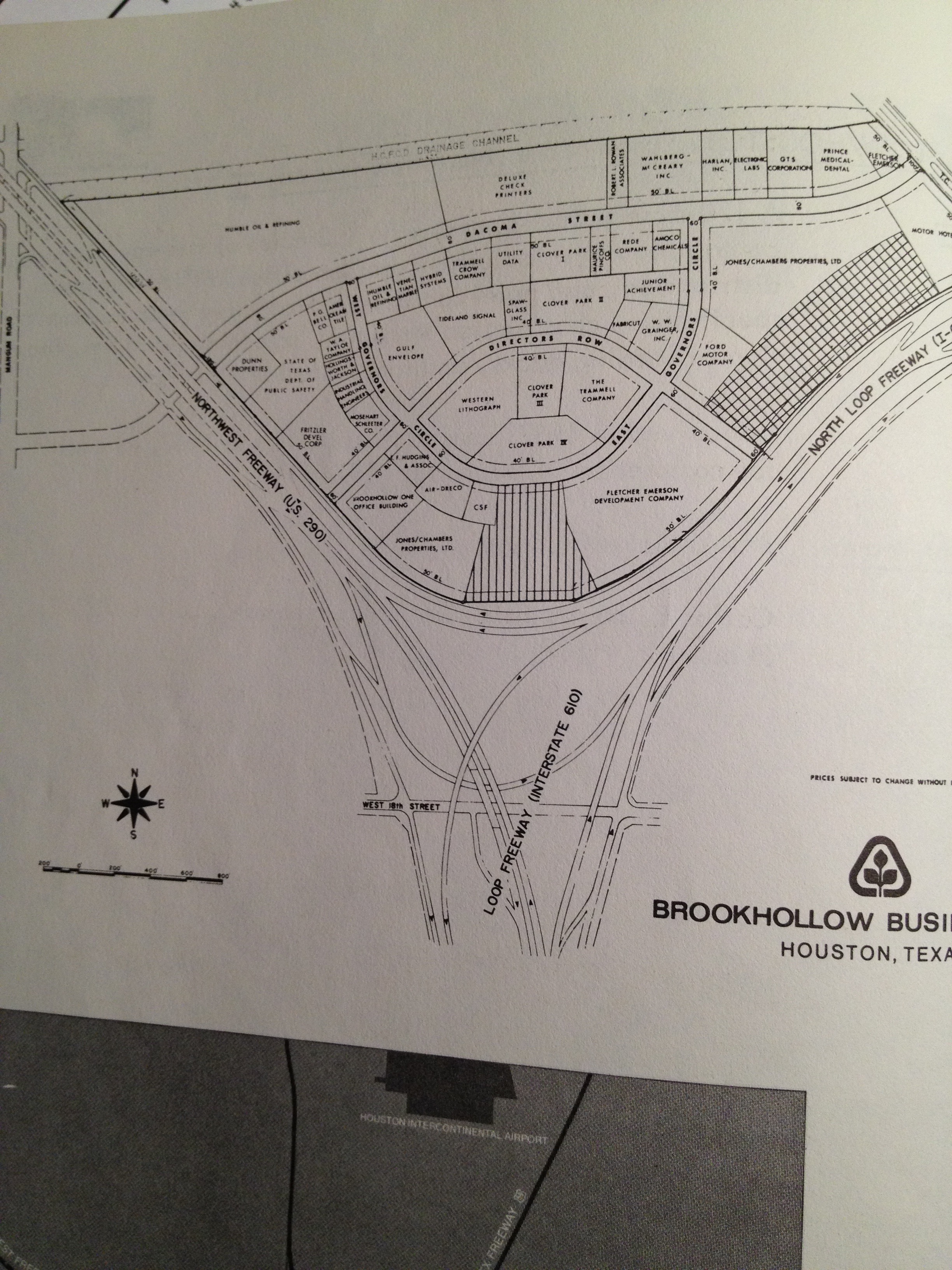
If the platting map is correct, Brookhollow of Houston had it replatted to its current state before selling it to Humble. I just remembered that despite my scan of Houston Today I got from another source is quite garbage when it comes to the Brookhollow map unfortunately but I did remember to take a picture of the page with my phone, seen here. The striped area is the hotel (Sheraton, but a Marriott in the 1980s), and that seems to confirm that maybe what happened is that Brookhollow bought the land, and redrew the plats to the future tenants of the business park, which were then actually sold to them.
Could you PM me a link of where you went to obtain this information on 290's infancy, Tiger? I distinctly remember a divided highway after Mangum, and I want to say it ran clear up to Cypress. After Cypress, the median went away and that old section of 290 (now business 290) is what it became afterwards. 290 in Houston, as I recall, was built in the median directly between the two double lane roads around 1981, maybe 1982. Now, I'm a little nuts, but I don't think I've taken the dive off into the deep end of crazy yet. My folks used this route to get to my grandparent's place in Bellville, and this would have been in the 70s. I didn't start taking the I-10 to Texas 36 route to get to granddaddy's until I was driving myself in the mid 80s.
Gracias, mi amigo.
Edit to add: Never mind, I see you linked the map in your post above. Have you ever found anything further on the more northern portions of the Northwest, between 8 and 34th? I know you have become quite the encyclopedia of knowledge on that particular highway since the construction began.
-
Neat map, Ross. Thanks for posting that. The inquisitive side of me wonders what the HLSR had in mind for use of that property originally? Headquarters, I presume?
Just to keep the good Tiger up to speed, Northwest Freeway is actually U.S. 290 not Texas 288. Looks like a simple typo by our fellow HAIFer Ross, but I thought that might need a little clarification.
Edit to add: As an aside, it's interesting to me to see the map use the term "Northwest Freeway" and to see the freeway laid out in full over Dacoma. The Northwest Freeway was merely a stub that terminated at Dacoma (perhaps it was at Mangum?) up until I was in my late teens. Interesting to note that this map, which would predate the expansion of U.S. 290 past the original stub by some 15 years, shows a full fledged freeway already planned out, documented, and mapped in 1967, when it didn't actually exist at the time.
-
1
-
-
3 hours ago, IronTiger said:
I was relying on the scan of "Houston Today", a 1970s volume of the "modern" developments in the suburbs and the downtown at the time (while it's great that there's a complete scan, some of the maps like Brookhollow are sort of illegible). It was listed as Humble Oil & Refining probably because they were the ones that started it, though by the time it was built, the Humble name had been discarded in favor of Exxon.
1972, I do believe, was when Humble became Exxon. So, you'd be right on about the Humble listing. Nice find, Tiger.
-
18 minutes ago, Ross said:
Yep, that was the ExxonMobil Brookhollow campus. Buildings were built in the "Brutalist" style, with lots of concrete. It was built in the early to mid-70's, and at one time had the card center that handled all of the credit card processes. I think the later occupants were IT and back office staff for some accounting processes, according to folks I know who worked there.
4400-4550 Dacoma St. 24 acres in total. Demolished building was 254,566 square feet, built in 1976 by Exxon. Latest appraised value of land that I could find through HCAD was $31,905,156. The entire complex apparently took 5 years to build, with 1971 showing as the initial ground breaking.
-
7 hours ago, cspwal said:
Still looks better than the Days Inn downtown
Post of the Year candidate is what we've got right here, folks.
Well said, cspwal!
-
 1
1
-
-
That would be eerily reminiscent of Town & Country's last days, with the mall gone and Marshall Field's building becoming the only remnant of what once was there. Having grown up with Northwest, it would be yet another loss of something from the childhood days, but so is the price of progress. I documented my last trip to the mal here on the HAIF, and I'm sure the pictures are floating around here somewhere. It wasn't even worthy of being deemed a shell of its former glory at that point in time. Quite depressing. It's really a shame that Almeda and Northwest are identical. Someone with a vision saw fit to save Almeda, yet Northwest (and its nearly identical footprint to Almeda) has seemingly been deemed unworthy of a revamp.
Oh well, the wrecking ball will never demolish all of the memories that I hold for Northwest Mall. R.I.P. old friend. I will never forget the butt whipping I received for running away from my mother in a mad dash away from Penney's and in to Foley's so I could get on that kid's shoes department's boat more quickly than the old lady could get across that mall.
It was worth every welt.

-
5
-
-
25 minutes ago, j_cuevas713 said:
All of the above
Any new word on Thompson's Antiques? I understood they were leasing the old Penney's box and weren't going anywhere, after being pushed out of their longtime home down on Old Katy Rd. for the freeway expansion. Could it be that the mall and the old Foley's meet the wrecking ball, while the Antique Center remains in place with a new "Northline Commons concept" in the rest of the mall's current footprint?
-
1
-
-
Well, if it ultimately turns into a bar, the old church will surely make for some fantastic photo opportunities of lightning strikes.
-
1
-
 1
1
-
-
Eh, just make the property a 150 pump Buc-ee's already, minus the Fitness Connection/Lord & Taylor/Mervyn's box of course, and call it a day.
-
2
-
-
That's only half of the story. Where's the picture of the mob, running at the white people, yielding sticks and screaming pure vile & hatred, which incited this lunatic to hop in his car and do the unthinkable?
But that's not what "reporters" are paid for these days, is it?
There's only one way for a foreign power to ever take out the United States, and that is to divide it and conquer it. This, dear sir, is the dividing. The conquering is forthcoming.
-
Aw, and I was really starting to like the girl from Austin, Chrisdyann Uribe. She's gone, Blue Dogs?
Any word on the M.I.A. Lisa Vaughn?
-
No place for hate? Look across the ocean. Plenty of it over there.
-
3 hours ago, CrockpotandGravel said:
Wasn't that the original plan year ago? An open mall like the ones in The Woodlands, Pearland, and Sugar Land?Not quite. There were parts of the Greenspoint Mall floor plan would've been left enclosed in the original layout. Others would have become open air.
-
2
-
-
28 minutes ago, Travis Simpson-Hun said:
We area Gay couple moving from Pittsburgh, Pennsylvania to Houston. We have 3 boys (4-5-8 years old) two are black. I'm Native American and my husband is European. What do you all think about The Woodlands & Spring Texas for a place to buy a home and settle down?
Do you all think that those two areas are nice, safe or open minded and tolerant?
---Travis & Stephen
travisbernard.hunt@gmail.com
Fantastic area, and please don't overlook Shenandoah. Great neighborhoods, community oriented, and you will find some nice homes on the market. This is between Hwy 242 & Research Forest Boulevard, west of the North Freeway. The Woodlands is a very busy area. If you need accommodations while you search for a home, please come and see me. I have a couple of nice Homewood Suites within 5 minutes of one another, and we'll be opening up a Home2 off of Tamina Rd. in the coming days. Feel free to PM me here @ the HAIF.
-
30 minutes ago, cloud713 said:
Yeah, I like alternate 1 the best, due to the downtown connectivity and the loop down Clinton.
Is the railroad museum at that old rail round table thing? I had been wondering about those random rail cars on the spur.
It was off of Mesa Drive. They used two out of service sidings to house the cars for several years. This was around the time they restored the M-K-T and Southern Pacific cabeese. I don't recall a turntable there, cloud. Only turntable that I vividly recollect in East End is the one at the Milby St. shops at York and Milby.
This is the video of the museum equipment being moved onto the Canal St. spur. The spur doesn't see a lot of activity, as you will see below.
-
3
-
-
2 hours ago, cspwal said:
Also - there's a railroad museum?
A nice one, too.
http://www.kingswayrc.com/gcst/
They have a restored M-K-T passenger car, caboose (MKT 6), SP caboose (4696), a couple of old switchers (one of which is an old HB&T unit), and a helium tank car. Weird, weird looking car to say the least. Last I saw these pieces of equipment, they were being stored off of Navigation, just west of Sampson/York, on an old rail spur. I believe the museum is moving, but have heard nothing recently concerning its venue change.
-
1
-
-
3 hours ago, mkultra25 said:
I just drove past the old Deauville Twin site on I-45 this afternoon, and wondered what, if any, vestiges of the theaters are still visible within the Family Dollar that currently occupies the site. Perhaps a field trip is in order when I have more time - it's been years since I've even been in the parking lot there, let alone inside any of the stores.
That would be interesting to hear what you find, mkultra. Along the same vein, here's a fun fact. Family Dollar on Parker Rd. @ North Freeway was originally 1/2 of the old Rice Supermarket. Behind the double doors in the rear of the Family Dollar is the back half of the former grocery store, stock room, bathrooms, etc. unchanged. Just a couple of quickly installed sheetrock walls here and there in the back. They use the area for regional wide meetings and such. If you venture down that way, be sure to say hello to Miss Carla, the store manager. From what she told me, the hair braiding studio next door (the other half of the old Rice) is also unchanged in the rear of the building.
Interestingly enough, someone was doing work inside the old Eckerd's next door to the left of the Family Dollar earlier this week. The space has been empty since Eckerd's moved that particular location from Parker to Tidwell in the 90s, now home to the CVS Pharmacy in Northtown's parking lot.
Edit to add: Next door to that is the Self Storage USA, former Builder's Square, former Woolco. That one is quite creepy, being inside that old Woolco with its deafeningly quiet interior, and very few lights illuminated within.
-
1
-
-
Gosh, Firebird, I shudder to think what may have been "Beyond the Door" at the Deauville Twin. One side X-Rated, the other general audiences. You just can't find quality entertainment like that in the here and now.
You have neglected the Greens Crossing Cinema, which ended its run around 15 years ago. Its final incarnation was a $1 cinema, but it did run new releases, if memory serves. I can't for the life of me remember the opening, but certainly seems like it was in the early 80's.
-
On 6/5/2017 at 0:20 PM, IronTiger said:
If only @Purpledevilcame back again, he'd probably have a lot more details on the ill-fated hotels.
If only....
I can offer up nothing helpful, Tiger. Not to sound stuffy, but I've never worked in, nor know any history about the Motor Inns of Houston.
-
1
-


Wolfe Nursery
in Historic Houston
Posted
@IronTiger I think the 1700 West Loop South address is accurate, Tiger. Seems there was a Wolfe there, and the HPD horse stables were next door. Getting to be too many years.
@Specwriter You know, you've really jogged the ol' memory. I believe you are dead on with your memory. It sat on the east side of 45 right before West Gulf Bank, not too far past Canino. I believe the new Auto Nation facility has been built where the nursery once stood. Prior to the new Auto Nation, that was where Fred Fincher Motors stood for umpteen years.