

gnu
-
Posts
1,146 -
Joined
-
Last visited
Content Type
Profiles
Forums
Events
Posts posted by gnu
-
-
The Baytown Popeye's was built in 1979 and maybe was a Popeye's from the beginning or turned in to one by 1984 - I don't think there was anything there beforehand but I'm not sure. If your time frame matches up, though, that could have been it..
Looks like H Salt is still going strong in California - this is the history they posted:
Cool. i will have to visit the next time i am in california

The H.Salt was somewhere in there and I know the Popeye's came later so I just assumed it was in that spot. This was about 1972-ish. I know the Jack in the box was there (although it was the old style 2-story box). I believe the KFC (now defunct) was also there. That leaves a big gap between it and Shakey's. Also the grocery store in the Bay Plaza strip was originally an A&P. It later became an O'Brien's (a local baytown grocer with several stores).
-
Here is the former Alfie's in Galveston. My parents and I went there several times when i was little.
And there was an H.Salt in Baytown in front of Bay Plaza. I think it is where the Popeye's is now.
Not sure if it is the same building. BTW. The building to the right used to be a Shakey's Pizza.
-
Harris county block books main page:
http://www.tax.co.harris.tx.us/Property/blockbooks/default.aspx
There is a Garfield street over off McCarty and Clinton.
And I know i remember seeing an old map with more "presidential" streets over there.
(There is still Fillmore and Buchanan)
Maybe it was a compromise when the two areas were annexed?
We keep these Presidents...y'all keep those....you get a poisonous tree....
-
Another find: Upas St. (which runs south from Fairview one block to Hyde Park, between Van Buren and Waugh) is called 'Underpass' on the Precinct 37 map.
Why 'Underpass", and when and why was the name shortened?
Underpass! Ha ha!
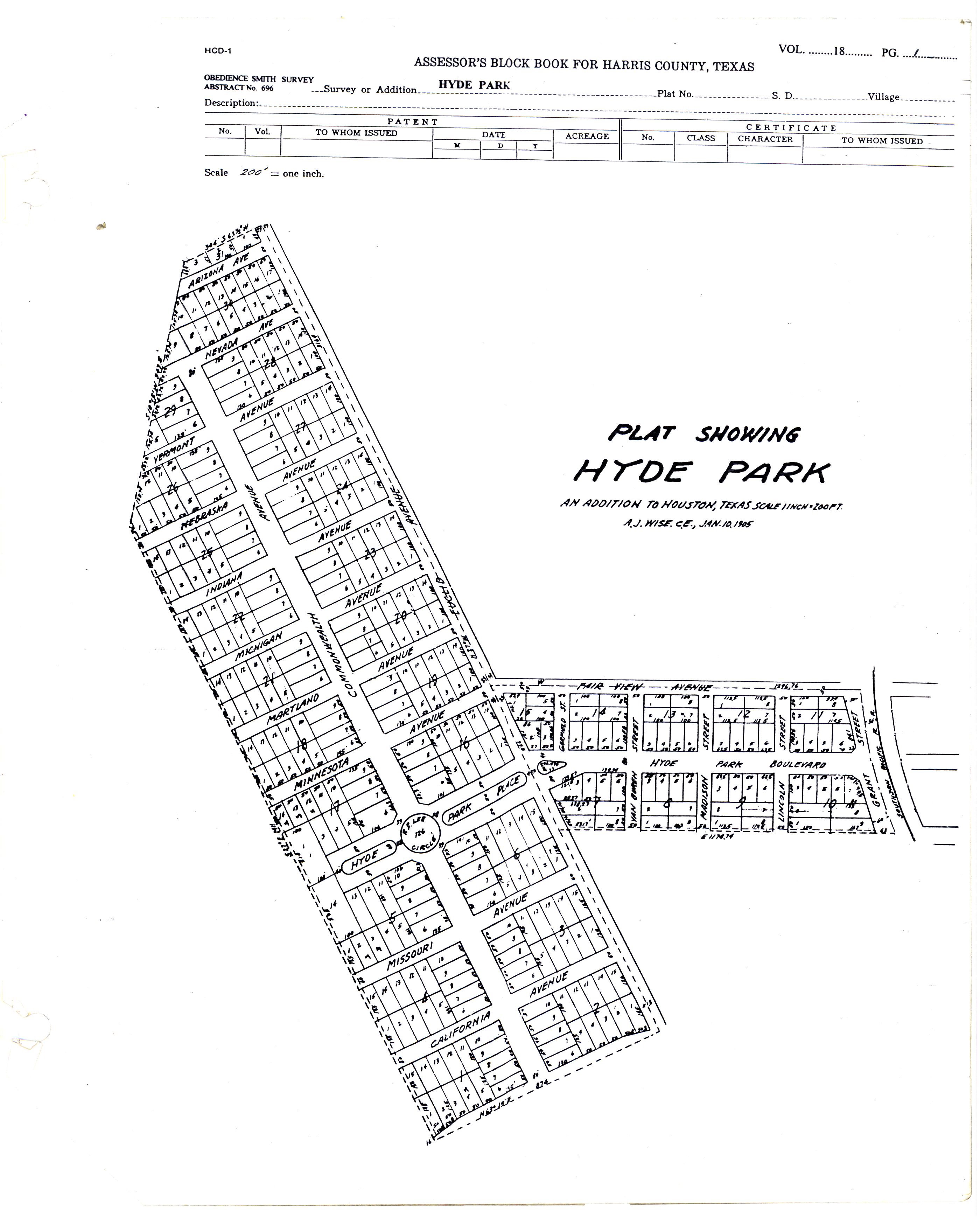
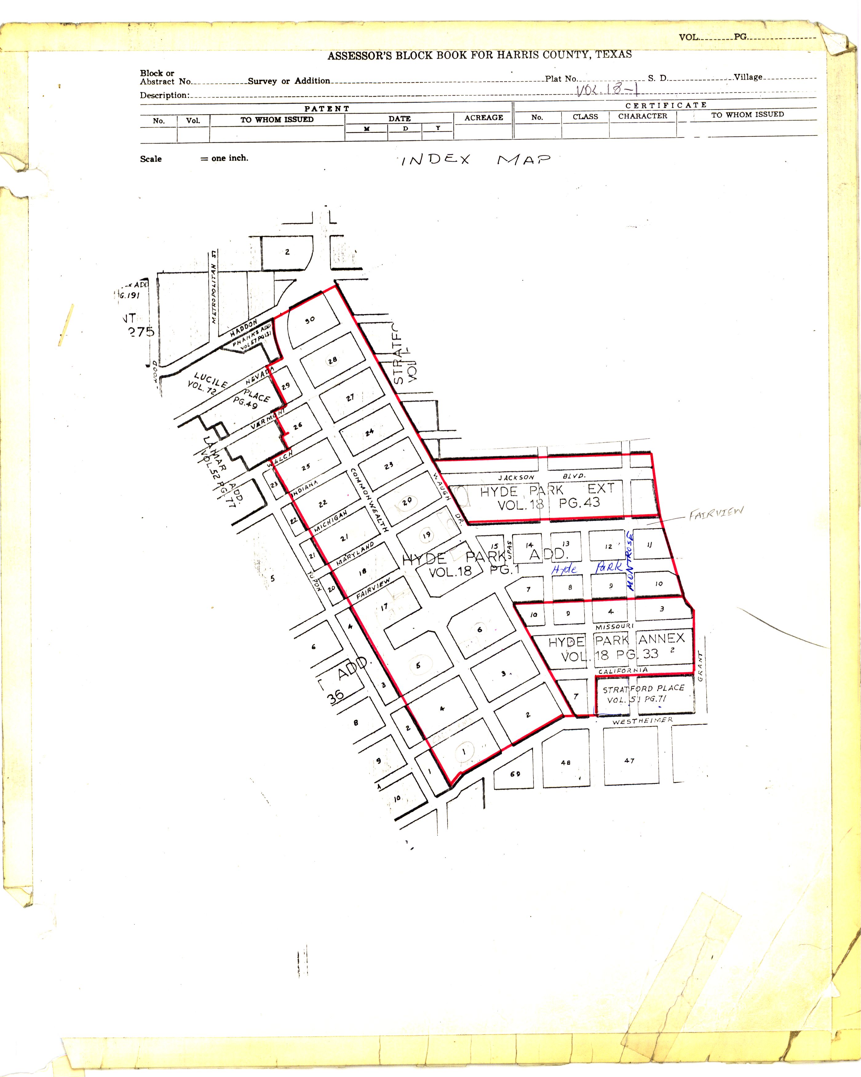
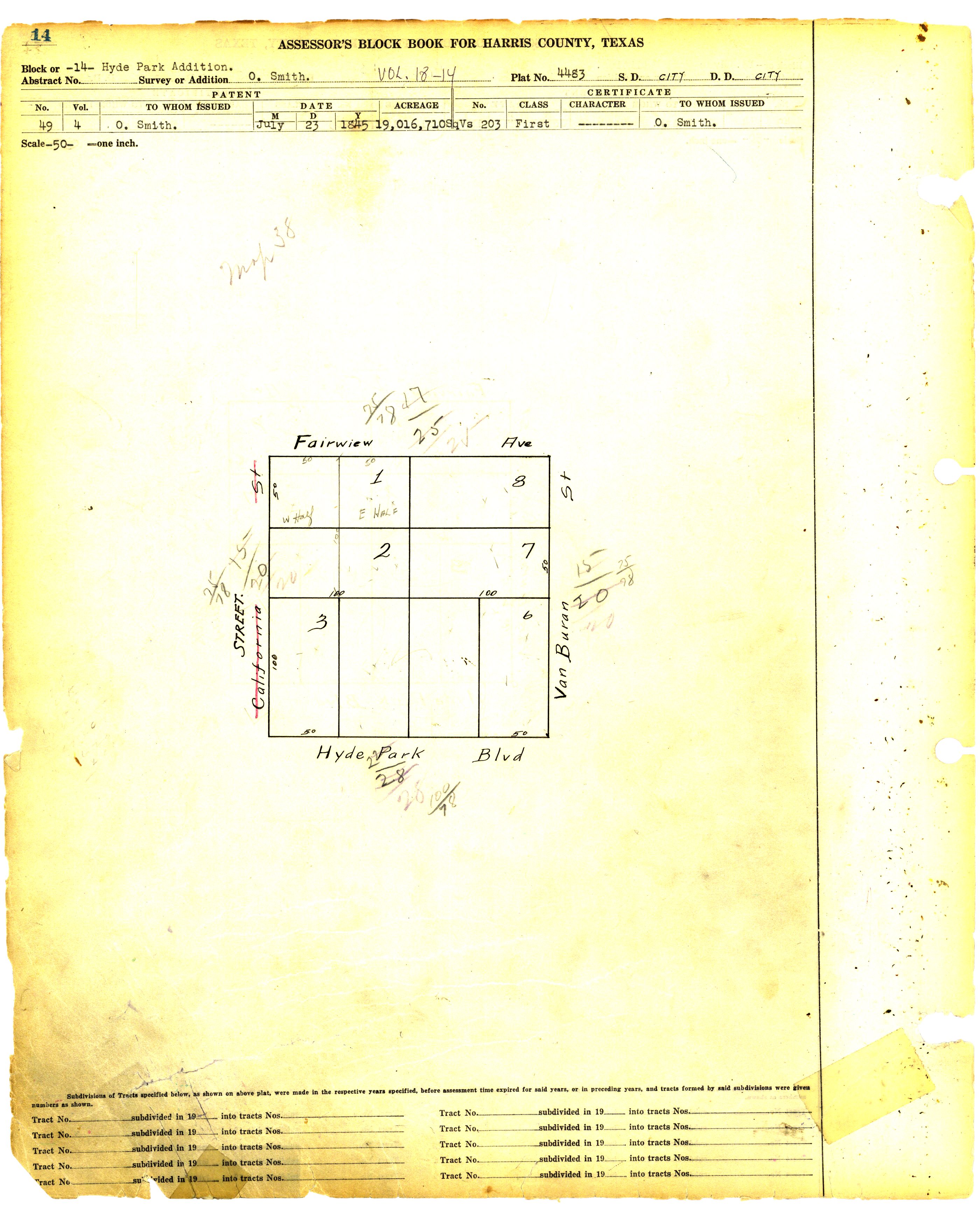
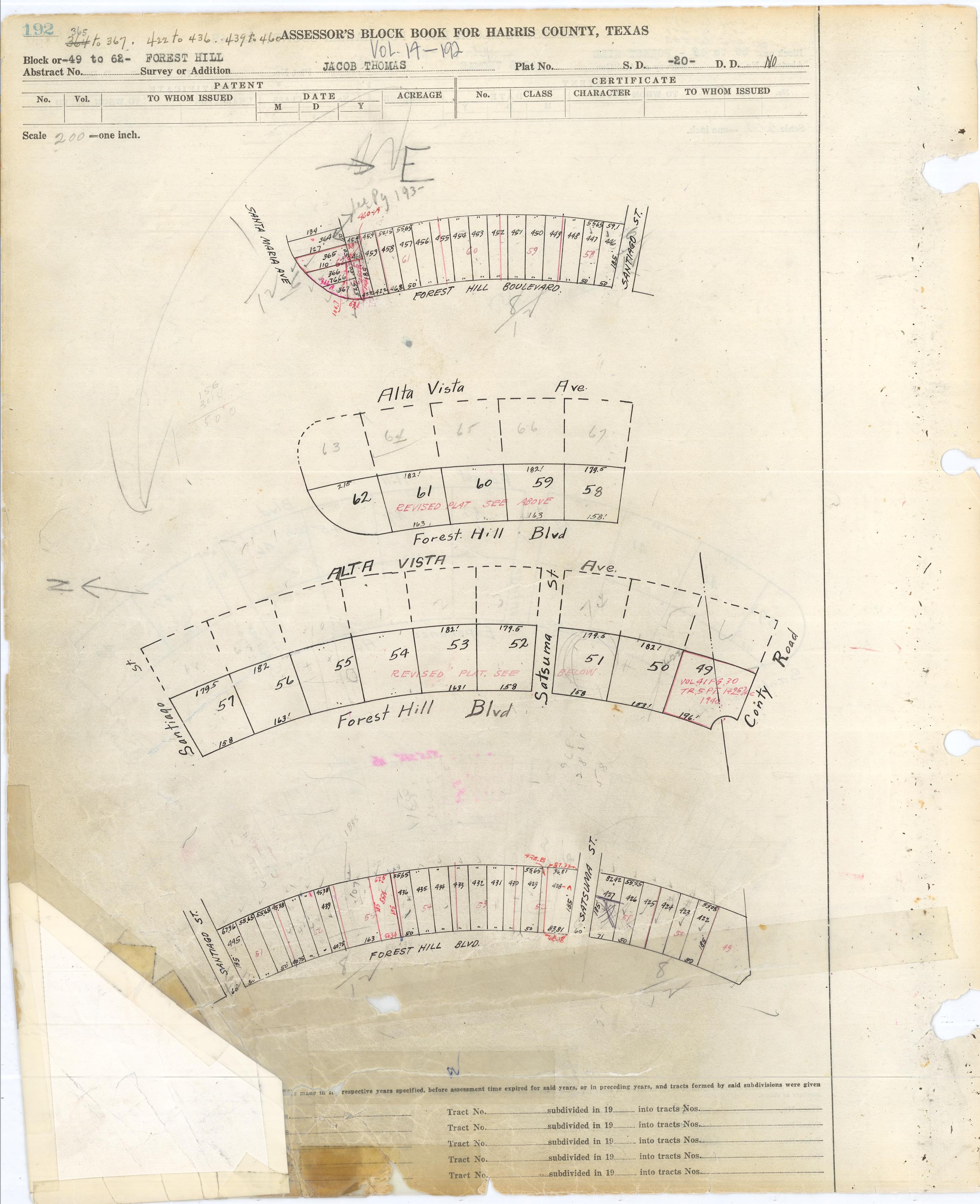
Here is a 1905 plat of Hyde Park from the block books.
http://books.tax.hctx.net/v018/AE1997_17-18_0261.jpg
looks like Upas was originally Garfield.
a later block book page (no date) shows it as Upas
http://books.tax.hctx.net/v018/AE1997_17-18_0262.jpg
and the detail page has it mislabeled as California and then crossed out.
-
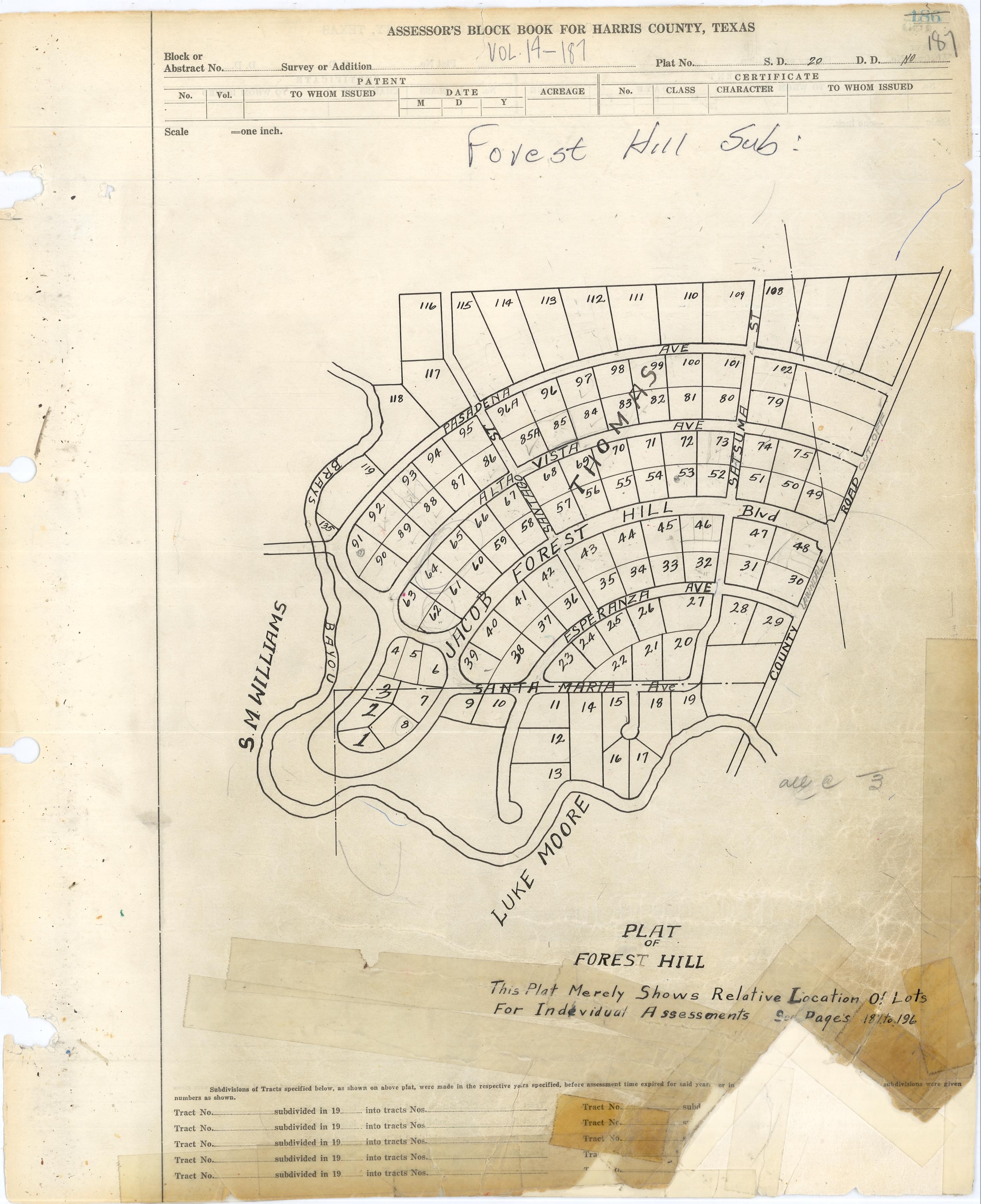
I'd also like to see the original plans for the neighborhood. I remember reading somewhere (I think it was in that Cite article) that the subdivision originally included the land that became Forest Park Lawndale. The developers sold it to the cemetery when they had difficulty selling the lots to homeowners.
Here is the "original" plat from the county block books. And it does incorporate the land that will become the cemetery.
http://books.tax.hctx.net/v014/003493.JPG
Notice that the original lot sizes are huge when compared to the 1928 re-plat. Looks like each original lot was split into about 3 new lots. Example below:
-
Guess no one knows why N. MacGregor Way (in Idylwood) sits no where near the other MacGregor Roads. I'm still looking for that one.
I think the original vision was to connect the two mac gregror's together running along braes bayou.
-
 1
1
-
-
I was just browsing google maps, cause I was disappointed when coldstone went out of business in midtown. I saw that there is a google maps listing for Amy's Ice Cream at 909 on texas avenue?
Is this true?
it is true...if you were looking 10 years ago.

-
Here I go again with 45+ y/o teenager memories, but seems like the one on Southpark was next to or very near the King Center Twin Drive-in movie.
The closest thing to a Mickey Dees hamburger in Houston, 1960s & before was a local (I think) chain called Prices. They had small burgers with mustard/ketchup mix, a couple dill slices & chopped onions, for 19 cents, I believe- fries were 12 cents. Prices was a walk-up with a few picnic benches & were all over town (also Pasadena?), but one was right down Southpark at intersection with Belfort, I believe.
from 1969: - sorry no pasadena directory

Price's Hamburgers
1: 3908 Bellaire (currently Jack-in-the-Box)
2: 8505 Jensen
4: 1728 Wirt
6: 8020 South Park (currently Tailor Cleaners - looks like it could be the original bldg)
8: 3425 Ella (currently Jack-in-the-Box)
-
Looks like McDonald's was here by 1972. The one mentioned by ernie on MLK (then South Park) was opened in 1972 and was the first black owned and operated McDonald's in Houston.
http://www.chron.com/CDA/archives/archive.mpl?id=2007_4346877
my 1957 phonebook shows the Mc Donalds drive inns at 2302 wayside (right by the 69th st bridge) and at 6339 South Park which would be almost next door to the later Golden Arches above that opened in '72
-
On similar note, I first saw KFC as a featured chicken item at Weldon's Cafeteria rather than a stand alone restaurant.
I think Hartz also had the Kentucky Fried Chicken "rights" in the 60's and early 70's
-
Rich Connelly at the Press posted these old photos that he received from Calvin Burdick Jr's son, Josh, that range from aerial views of the city to pictures of the Exxon building when it was first built to old downtown street scenes:
http://blogs.houstonpress.com/hairballs/20...uston_--_in.php
Rare to see pictures from back then in color. Cool stuff.
*side note* I hate slideshows, too. If there was a way to post the photos individually, I would.
great photos..thanks for the link
i think the owner posted these photos several months ago on haif...there is a thread around here somewhere.
-
Never went to the theater but I went to Warren's Hobbies. It was in the shopping center across the street (where Kroger is).
Where was the Kip's Big Boy? Seems like it was on the corner near the theater.
-
Yeah...that's it. There is also a bldg. that faces the circle, same side, SW, that has been there a long time. Believe there is a florist in it. It's before the post office.
The Flower Box
-
I may be getting that pharmacy by Weingartens mixed up with the little rectangle bldg. (drug store, maroon color on front) on the south side of the road, across from the previous Weingartens location. I have a picture of it here, somewhere on HAIF. It is very old, can't recall the name, right now. We never shopped over there, just remember driving down Park Place Blvd. alot, with my grandmother... sometimes to go to the Santa Rosa theater.
you mean Park Place Pharmacy..across the street (currently) from Kelley's (Langs/Weingarten)
I believe there was an older version of Lang's that was closer to the circle, that was removed when they built the gulf freeway.
George Harris was the longtime owner of Park Place Pharmacy
-
It seems this one owner house was built for H. S. Hayre who is an electrical engineering professor at the University of Houston.
Make that WAS an EE prof at UH. He died last year. Hence (i guess) the sale of the house.
RIP Dr. Hayre. RIP cool house!
Got my real estate friend to look up the listing. This is quoted from the agent only remarks:
"Foundation on present home built in '59 cracked and severly outdated."
uh oh! it is "outdated," i guess the only choice is to bulldoze it and build a cathedral

-
The building is long paid-for, but the congregation is struggling. They've consolidated with others in the area, but still don't have the numbers to pay the bills, so the building doesn't get cared for as it should.
Sorry to see they sustained so much Ike damage and that the congregation is struggling.
Hopefully they find a way to save the original Park Place Baptist Church Building - before they moved across the freeway in the 50's. It's the red brick building next door to the main church - corner of Kingsley. It would be a shame to tear it down just for more parking (as shown in their plans).
http://maps.google.com/maps?f=q&source...6744247576,,0,5
BTW, the current Methodist church building partially sits on the location of the old Park Place City Hall and Fire Station.
-
Anyone know when the Luby's was inserted into that mall?
Luby's was an original tenant. Unfortunately they closed a few months ago.
-
Trouble is, I can't remember exactly where it was located. Was it in Sheldon, further east in Crosby or more west toward Houston?
I think it was right at Sheldon and 90
across from the paper mill
-
So my questions are:
1. How is the sound proofing from <excessive> street noise such as partying? I know there will be some street noise; such is living downtown. But I want to know if the Friday/Saturday night madness becomes cumbersome.
2. How is the sound proofing from unit to unit?
Any other general comments about the experience of either being in, or living in the place are welcome. I've read all the comments on apartmentratings.com, and have looked at a 500-something sqft 1br unit on the 6th floor of the building, which I'm considering leasing.
Thanks much in advance!
i lived there from 1999-2001 on the north side of the 13th floor. the noise from the street was pretty loud, especially from clubs late on friday night,
but the air conditioner usually camouflaged it enough for me.
i never had any problems unit to unit - it might be that i had quiet neighbors. however, i lived near the trash chute and i could hear when people opened the door to drop in their garbage.
i didnt like sharing the washing machines and on the weekends I would have to go to different floors to try to find a free machine.
all in all my experience was good. i would do it again if i could.
-
1
-
-
Does anyone remember A&P supermarkets? I can vaguely remember going to one in the early 60s when I was a kid. I remember they gave PLAID trading stamps. Maybe if someone has access to a Houston Yellow Pages book, they can look up where they were located. I could probably pinpoint the one I went to way back then. It was between 1960-65.
Here is a list from 1956:
General Offices: 7800 Washington
Stores:
5006 Bellaire
2420 Crawford
2900 Luell
6735 Richmond
813 E. Shaw (Pasadena)
2930 S. Shepherd
4965 South Park (MLK)
5305 Telephone
8213 Long Point
-
Yeah, I remember the Riverside which was on a bluff just north of I-10 in the Four Corners area. Magnolia Gardens was further up the river. It did burn down, but I can't remember when. Very popular place.
i believe Riverside Inn was right here:
http://maps.google.com/maps?f=q&hl=en&...&iwloc=addr
On River road just north of 10 on the main river channel. There is a store and boat ramp still there or there was several years back.
Could you be thinking about Tugboat Annies just north of 4-corners on 2100?
-
I don't see any threads here regarding Magnolia Gardens which was, for years, a popular music venue where country-western acts as well as early rockers like Elvis, Carl Perkins, Jerry Lee Lewis and Johnny Cash played often. The place sits on the San Jacinto River, I thought in the Cloverleaf/Channelview area north of I-10, but I believe that it is actually north of old Highway 90. The old memory is pretty unsteady about this since I haven't been there since about 1973 or so. It had a big open-air dance floor and bandstand in its heyday.
When we would fish the San Jacinto, my dad liked to motor over there in the boat and talk about all the people who played Magnolia Gardens. By that time (the 1960s) I remember that it had a restaurant/club that overlooked the river and they used to have boat races. Singer Rodney Crowell wrote about seeing shows there on his 2001 album The Houston Kid (which any HAIFer who prowls the history board should have).
Any memories, relics of the place?
Magnolia Gardens is off of Garrett and Sheldon rd North of (old) hwy 90
http://maps.google.com/maps?f=q&hl=en&...055275&z=14
No memories other than when it was a place to go swimming at the river and seeing people swimming there when we skied by. (80's)
I always heard it was a big deal with the Big Bands in 40's and 50's (similar to Sylvan Beach).
-
Can any provide background or information on the brick building on the northeast corner of Wayside Dr. and Harriburg Blvd. which used to be an old telephone exchange for Southwestern Bell? As early as 1925, the property had some kind of telephone exchange structure on it according to some old Sanborn maps.
The building is solid and looks structurally sound but I see no traffic entering it. Is it currently being used for something?
I imagine it still holds all the circuitry for all the phones in that part of town. (Central Office - Wayside Exchange)
Most of it is automated now, so there wouldn't be a reason for a lot of people to go in and out of the building.
-
btw...found this in the google LIFE pics. It is a nice July 1952 picture overlooking the Shamrock Hotel pool. The Prudential Building is in the background with its large gibraltar logo.
http://tbn0.google.com/hosted/images/c?q=1...404d650f0_large
-
1
-


Letzerich House in Friendswood
in Houston Mod
Posted
I don't think it was moved.
I think it was demolished.