

NenaE
-
Posts
2,194 -
Joined
-
Last visited
-
Days Won
5
Content Type
Profiles
Forums
Events
Posts posted by NenaE
-
-
Fantastic use of photography lighting, of great old buildings.
-
I think it's different for every person. For instance, some are searching for a restaurant, and it comes up on Google, under HAIF.
And they never visit again.
As far a joining, there is a level of intimidation on HAIF, people are quick to correct you. I think this why I was a lurker for awhile, why some don't join.
I used to read HAIF posts on my lunch break, at work. Time was a factor.
I eventually joined because I knew my long unanswered questions about Houston architecture could be answered by this particular group, in a matter of minutes, sometimes, I could not find that anywhere else.
It was Historic Houston architecture that definitely drew me here.
-
 1
1
-
-
I sure never saw any similarity with River Oaks. When I was a kid it was just a lower middle class working neighborhood. By the early '60s, the neighborhood had gotten pretty rough & Dogpatch was borderline slum area (in my opinion).
Oak Meadows (other side of tracks & OGR) was several steps up from Meadowbrook, while Glenbrook Valley & Meadowcreek Village were where the "rich folks" lived. Seems amazing that Glenbrook Valley is now "historical", since I remember when much of the neighborhood was "under construction".
I think maybe the Glenbrook Country Club promoted that idea.
Your perspective is interesting, I never thought Oak Meadows was considered nicer that Meadowbrook. I grew up in Oak Meadows, years - 1960's.
They felt like they were closer to the chemical plants, all the same tract homes, maybe they were desirable because they were newer construction.
The ones in Meadowbrook ( two-stories on Howard Dr. & all homes on north side of neighborhood) fascinated me, they were all so different.
I, too, grew up thinking the rich kids lived in Glenbrook & Meadowcreek.
I love the aerial shot I posted recently, above, due it's green space.
As for Glenbrook, was glad to see any SE Houston neighborhood architecture get some recognition.
-
The above long post is the one that I didn't lose...
 .
. -
Even though I got the pink error notice this morning while posting, I didn't lose the post...whew.
Thank goodness...it was a long one. Didn't show up immediately, in the new posts, but it was in it's category.
-
My first required reading for my Industrial America class was a great book about Chicago's Architectural history. It was a coincidence, since I was just studying the architectural history of the city on my own.
It's called :
THE DEVIL IN THE WHITE CITY - Murder, Magic, and Madness at the Fair that Changed America by Erik Lawson. He's also the author of Issac's Storm -1900 Galveston hurricane.
The Chicago book documented the building of the World's Columbian Exposition, 1893. Chicago's prominent architects wanted to surpass Paris, with their architectural talent. It's main architects are
Daniel Burnham, Charles McKim, John Root, Louis Sullivan, and landscape architect Frederick Law Olmstead. It describes the building of the first Ferris Wheel.
There were murder mysteries also included in the book, during the time period; one person in the story was an actual serial killer. I have to say, didn't enjoy that part very much.
I've been meaning to look the architects up, in my Chicago architectural handbook. The book's conclusion mentions the Rookery still standing, as well as one bldg. from the actual exposition. Many of the bldgs.are gone, had caught fire, but there is an island, Olmstead created his magic on, still there in some capacity.
Maybe Editor knows something about all of this, I must visit this city.
-
Methinks this may not be it. The Carrousel was on Reveille, immediately south of 610. With the google satellite view one can see the triangular layout, the circular office/lounge, and the outline of the swimming pool.
I am actually pointing out the sign that was also a carrousel, sitting now in someone's private salvage yard. I guess I should have bolded the word sign. There were two of them...the smaller one sits in this enclosed yard, per the guy from Facebook.
As kids, we were more intrigued by that sign, than the actual Motor Hotel, because it twirled, with horses, at Christmas, a dummy Santa rode on one.
PS: I was lucky enough to grow up with that place, guess the sign reminded us of Peppermint Park, across the street.
-
Methinks this may not be it. The Carrousel was on Reveille, immediately south of 610. With the google satellite view one can see the triangular layout, the circular office/lounge, and the outline of the swimming pool.
I guess I should have bolded the word sign...the resting place for the carrousel motel sign is what I'm talking about. There were actually two, it is the smaller one is the one I think sits in that enclosed yard...The people (like myself) who grew up with that sign loved it so much. Had horses, twirled around, at Christmas, had Santa on it.
-
It's a shame it was allowed to decay...one person on Facebook was just saying that, way back when, probably 1940's, Meadpwbrook was considered the River Oaks of the southeast side. Don't know if I'd go that far, but it was a beautiful property, around the golf course, country club, until the stinky petro-chemical companies arrived. I can say that, I grew up next to them.
-
...here's a GoogleEarth aerial photo of where the Carrousel Motor Hotel Sign sits.
My source of info. was Rusty Shackleford (Thank you) on the Park Place Info. (Facebook) site.
He has posted a photo of the top of the sign's star, seen from the top of the fence. Check it out. He talks of the owner having lots of antiques, doesn't want to sell them. I wish I could visit this place. adddress : west of 7231 Long Dr. Notice it's the octogon shaped rusty figure. Looks like it, to me.
-
maybe i don't understand your question but these all look like partially constructed houses in the santa rosa subdivision.
the ones with small squares along park place might be foundation pads for houses that will be built.
if i remember right, from my research, the first part of santa rosa was built in 1943 and then the rest didn't come until after the war in about 47 or 48.
I'm thinking that they may have been temporary military housing, in later aerial photos you can tell that they were replaced with another type of housing. I thought, as you have, that the specks looked like house foundations blocks, from bldgs. that were already removed.
I thought that the little white houses (if that's what they were) maybe were linked to the airport, in some way, maybe the airforce.
The street name Reveille leads me to think this, as well.
Here is a link with the types of housing that may have been similar. Again, just an idea. I like to wonder.
http://www.sloanegal...on_and_camp.htm
if you arrow to the right, in the small pictures, you can see one picture of the boys & barrack-looking housing. This is what I think was sitting there. They would have been easy to move.
-
I've always wondered about these white squares...does anyone know what they were? Major intersection (green) Park Place & Hwy 35 (Reveille), other minor streets are Moline, Edna, Juniper.
Wonder if it had anything to do with temporary housing or even tents.The road Reveille did lead to the airport. GoogleEarth Map - 1944. Maybe it's just some chicken coops or orchards? haha...I'm making up stuff, now.
-
<BR><BR>Here's a 1944 aerial shot of Meadowbrook, Sam Houston Gardens, and Glenbrook Country Club, from GoogleEarth.<BR>The arches were probably removed by that time, I can't spot them in this photo.<BR>What really interests me about this shot is this: notice all the little square white houses on the streets Lenore & small part of Barkley, next to the military housing. Wonder if they were built as part of the govt. facilities, as well. Notice how different they are, from the Meadowbrook lots. They are so identical to each other,<BR><BR>PS: I'm still learning how to edit/ download a photo properly... <BR><BR><BR>
-
http://www.thescenem...05_02-p20b.html
... a few links about the West mansion.
...the views out the windows of the property are beautiful, and those staircases take my breath away.
...had to put on earphones to hear the voices on the youtube tour.
http://lonestar.texas.net/~mdmclean/J_M_WEST_BIO.html
...towards the bottom, describes the mansion materials, why he sold the property, oil on it.
-
It is. There was allot of Westin talk in this thread, so I thought this might be the best place for the pic.
About the Westin pool, I like it...but is that a rendering or an actual photograph?
Hard to see what's going on with the pool, on the right side of it, where it meets the glass.
I love the whole layout.
No negativity here.
-
the model was in the I A Naman + office lobby when I went there a couple weeks ago....
I'm glad the model found a good home.
I had forgot about this bldg, but remember that astroworld (corporate?) office bldg. ? was round, seems like it sat close to or on the water, near the front.
And that front fountain was beautiful, with the world globe.
-
^Looks like it's 8219 Glenalta. When I'm having trouble with addresses I sometimes go to the TSARP map (http://maps2.tsarp.org/tsarp/) - here's a screenshot:
Oh, cool ! You just showed me a new map link to look up address info. on, Thanks sevfiv !
That's for sure the right location it, double lot, same address.
That area is confusing, the same streets are found in a different section, one in Glenbrook Valley, other side of drainage canal, to the west.
-
My new favorite is Russo's NY Pizza Kitchen, super-thin crust.
-
http://en.wikipedia....s_City_Disaster
Texas City must have many post 1947 structures in the area, still standing.
-
Excellent, find the site very user friendly!
I don't know much about Texas City, looks like there are many bldgs. still standing.
My dad used to talk about the explosion, and show us the anchor that landed far away, by some hotel near Galveston Bay.
-
I have a question about a house that sits on Glenalta, in Meadowbrook Freeway. It has a double, deep lot, back lot sits on Glenscot (map spelling) Glenscott on HCAD info.
The house in question sits on the fifth lot, counting back left, north side from intersection of Glenalta & Hinman.
GoogleEarth says the address is @8357 Glenalta. Corner house is listed as 8315 Glenalta. (I don't like the newest version of GoogleEarth, seems harder to get addresses).
I've studied this house before, something weird is going on, with the street addresses. You know how they can change, mid-street.
Whats the real address?
I'm trying to find out who the previous owners were, if it was a house I visited as a child. It's a wild shot, I know.
The family had a rectangle pool, huge lot, had an Asian rickshaw, an older boy pulled me around the pool in it.
Was in the 1960's. The house itself left an impression on me, the whole back side of the house was glass, sliding doors (maybe), typical sixties fashion. We visited at night, it had landscape lighting, was beautiful.
I've vaguely remember white, very plush carpeting, in the living room, as well.
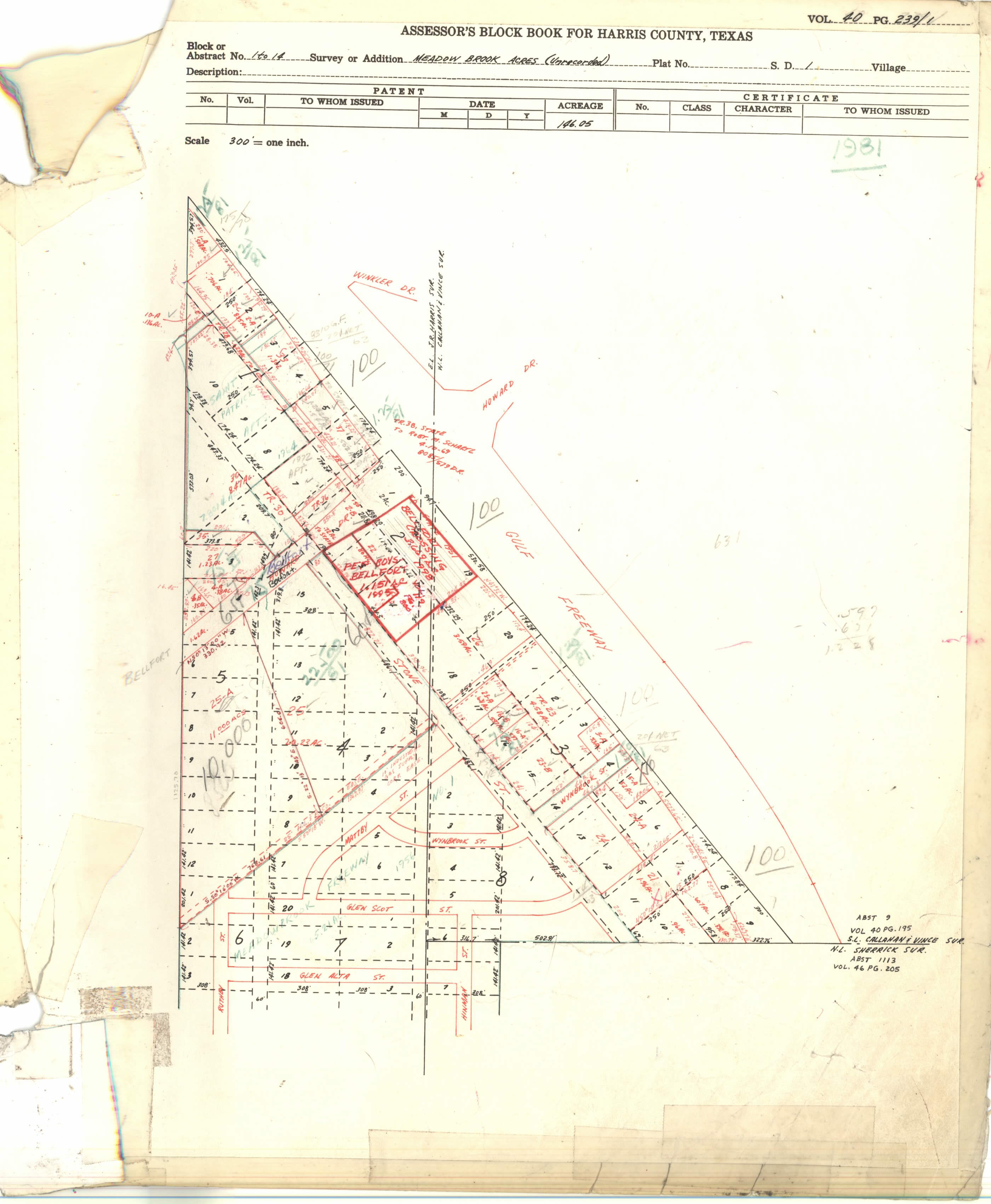
http://books.tax.hct...7_40-2_0243.jpg
Block 7, lot 2 ?
-
Speaking as someone who kayaks solo in east Texas and out on the Gulf... Yum.
My dad loved to canoe, the Trinity is where he explored the most. I love to eat seafood, don't desire to be a meal, or even a snack. I like Hill Country water, cold & clear.
Tasted a wild pig before, was slow cooked all night, by a friend in Rosharon who actually hunted them. Boy, was that good.
-
Cool picture of the slide, groovy side panels, reminds me of the Laugh-In show.
Here's a short article of the inventor of the giant slide. says there were 42 of them, at one time.
-
LOL...Alligators, crocodiles and sharks...three things I try to avoid. Oh, and water mocassins.


 <BR><BR>Here's a 1944 aerial shot of Meadowbrook, Sam Houston Gardens, and Glenbrook Country Club, from GoogleEarth.<BR>The arches were probably removed by that time, I can't spot them in this photo.<BR>What really interests me about this shot is this: notice all the little square white houses on the streets Lenore & small part of Barkley, next to the military housing. Wonder if they were built as part of the govt. facilities, as well. Notice how different they are, from the Meadowbrook lots. They are so identical to each other,<BR><BR>PS: I'm still learning how to edit/ download a photo properly...
Camp Warnecke And Camp Giusecke
in Other Texas Places
Posted · Edited by NenaE
My friends and I use to rent a house on the Comal, mid 1980's, probably. It sat right by a train track bridge, across from the Wurst Fest Hall.
That old house is no longer there, swallowed up by condo rental units. Those were some fun times.
Just Googled it, was off Landa St.