

sapo2367
-
Posts
307 -
Joined
-
Last visited
-
Days Won
2
Content Type
Profiles
Forums
Events
Posts posted by sapo2367
-
-
I feel safer already 🤣
-
 1
1
-
 1
1
-
-
16 hours ago, s3mh said:
I live a few blocks away from 11th street on the west side of Heights Blvd. I walk, run, bike and drive around this area all the time and have been doing so since I moved into the neighborhood 15 years ago. There has been no noticeable change in cut through traffic as a result of the changes on 11th street. If you take W 8th instead of 11th, you are not saving any time as you hit multiple stop signs and have to weave back over to Shep. There has always been more traffic W 8th versus W9 or 10 because there is a school and church on that street and a lot more traffic coming through MKT. There is also a busy daycare on Rutland. But the lion share goes to MKT.
I'll second this, the school, daycare and MKT all draw a lot of traffic to 8th street -- nothing to do with the 11th street re-do.
-
3
-
-
I've been keeping an eye on this as I bike by on the trail -- I don't think its energized yet, last I saw they were working on the connection to the substation.
FYI I think it is related to this project down at the TMC https://www.centerpointenergy.com/en-us/corporate/about-us/news/1626
-
1
-
-
"Congestion increases the cost and delivery time of commodities such as Amazon deliveries groceries and commercial goods," a TxDOT official said during the presentation.
Glad that TxDOT's priorities are clear.
-
1
-
 1
1
-
-
On 2/5/2024 at 8:41 AM, steve1363 said:
Don't blame the church. What about 11th street?
I mean, they were directly opposed to the project prior to construction (as evidenced by earlier posts in this thread). I don't think its a stretch to conclude they still aren't fans and have used the change in leadership as an opportunity to get what they want.
I should be clear I think its probably influential congregants, not the church itself (although they did pretty publicly use their church sign to oppose it).
11th st is the same -- someone has Whitmire's ear and has a vendetta against non-car related infrastructure in their neighborhood.
-
4
-
-
8 hours ago, Triton said:
I will say, out of all the things to start with as mayor, this has to be the most bizarre ones. I can understand redoing a project in the planning stages but this feels more like a waste of money to completely redo a project that was just finished.
I think some influential people (read donors with a lot of $$$) attend that church and are pushing hard against this project. I doubt the mayor’s office actually cares all that much one way or the other, but is probably doing a favor to someone who has had it out for the street improvements since they were announced
-
1
-
-
Since I just did the search -- figured I'd save y'all the time
-
2
-
1
-
-
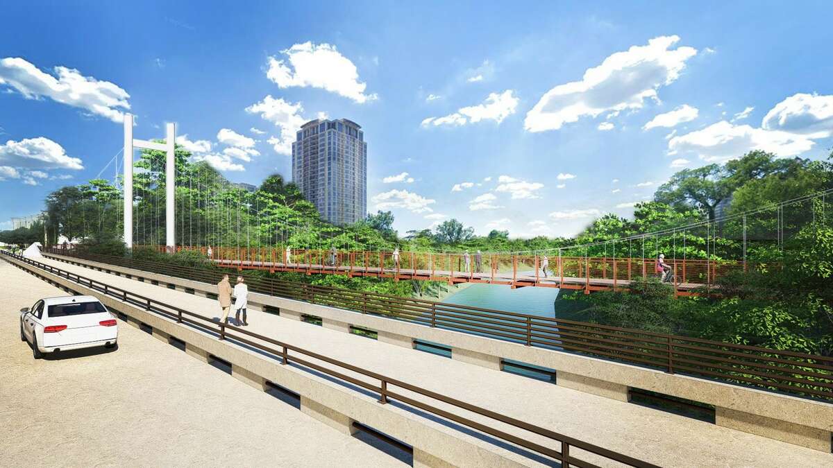
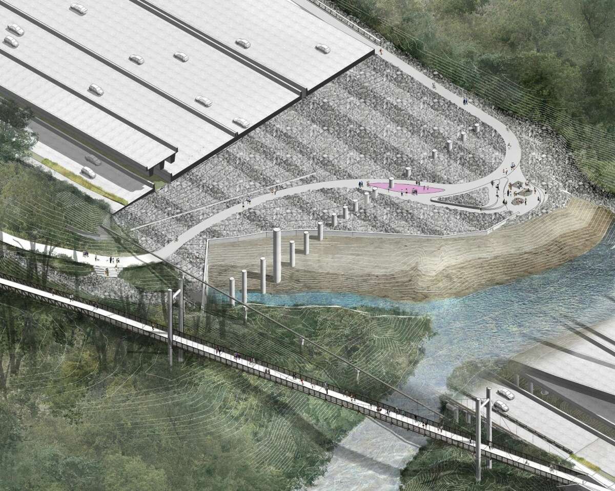
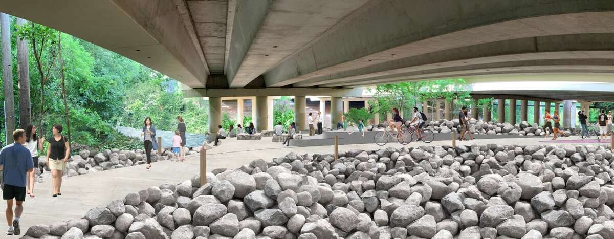
On 11/2/2023 at 10:50 AM, ChannelTwoNews said:
Renderings from the article

Love their optimism of the rendering of the trail under the highway. I'm pumped for this trail but those underpasses get gross looking real quick
-
From the IG account BigDumbTruckClub — but very applicable here

-
1
-
5
-
-
- Popular Post
- Popular Post
-
14
-
1
-
Houston removes bus islands after complaints from city's worst motorists
The floating concrete bus stops at 11th Street in the Heights have been demolished following complaints from large vehicle motorists and an ensuing safety inspection.
-
3
-
1
-
-
Sad news, hopefully this can be restarted if the funding appears. Also we need to change this title -- I keep thinking there is good news and then I read the post.
-
The old brick street is showing through — they should just bring this back :) will definitely help with traffic calming
-
4
-
-
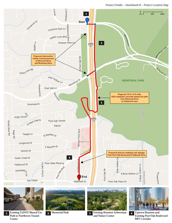
2 hours ago, talltexan83 said:
I've heard that Bayou Bend/Hogg Sanctuary would like to be a part of the project. It makes sense as they could see a nice influx of visitors arriving on bike.
So if the path can reach those sites arriving from the east, then the last portion of the path before Memorial Park would have to involve ROCC. Obviously, there would be some challenges there, but maybe a fixed skyover (just using the banks on the ROCC as anchors could work). That's my dream at least. Given the potential here I hope the planners are thinking big. Being able to avoid Memorial Dr all together would make this one of the coolest rides in the city.
Love the idea of an elevated bikeway over the bayou banks to get to Memorial Park -- would be a super cool feature and would in itself draw people to the trail. I also hope that the Bayou Bend is included on the trail. My dream would be to see that bridge across the bayou opened to regular bike/walk traffic and have the trail connect down into River Oaks. Ofc this won't happen b/c too many wealthy people would have to deal with the scourge of bicycles and walkers outside of their houses (the horror!).
-
1
-
-
My prediction -- surface parking lot 😪 Its like a block from where the new I45 reroute will go so I wonder if whoever buys it will wait for that project to complete before really doing something with the property.
-
1
-
 1
1
-
-
1 hour ago, Justin Welling said:
“Whoever put those there clearly drives a sub-compact (car),” said Michael Reese, who drops his daughter at school each morning by driving north on Heights, then south to his downtown job. “The first time I came up to it, I didn’t think I would fit.”
The lane was plenty wide, even for buses and commercial trucks, but the perception dominated the reaction, and the black marks along the yellow painted curb showed some drivers could not keep from bumping the platform.
Its amazing to me how poorly people understand the size of their vehicles.
-
6
-
-
On 8/13/2023 at 12:55 PM, editor said:
In Chicago, there's one point where a cycling path has to share space with a freight line over a bridge. Fortunately, the trains are infrequent and very slow, so everyone has lots of time to get out of the way.
Any pictures etc? Sounds interesting :)
-
Here's my guess -- I have a feeling Brenners on the Bayou will try to avoid having the trail run between the restaurant and the bayou
-
8
-
-
- Popular Post
- Popular Post
On 8/30/2023 at 11:44 PM, august948 said:Just released conceptual for the extra lanes...
From this thread -- here is the official rendering
-
3
-
13
-
I found this article really interesting. Talking about how both of the leading candidates are basically in the twilight of their political careers, and how that differs from Houston being such a young and dynamic city.
https://www.texasmonthly.com/news-politics/houston-mayor-election-whitmire-jackson-lee/
-
2
-
1
-
-
2 hours ago, EaDolivin said:
I'm a nearby property owner and I got the Public Hearing Notice. Here's what I can summarize:
"the applicant proposes to replat lots 3,4, 14, 21, 24, 27, and 30 of Williams on Commerce, single family residential plat recorded in 2017, in order to build 7 more units than the original plat allows.
Then it references local government code 212.015 and Houston Code or Ordnance Chapter 42.
Basically the new lots don't meet the minimum lot size and width per the city codes, and they're seeking a variance so they can build them. 7 more units than the original plat allows though? Seems like a bit much.
I'm noticing that some of the plats are bigger than the houses they have initially built (for ex plats 15-19 in the photo above). I wonder if their original idea was to work up to larger, more expensive houses but with interest rates higher they want to instead sell more smaller ones instead.
Side note, I toured one of the existing houses a while ago. They are SKINNY. Its basically enough width to fit one car and a stairwell.
-
On 7/29/2023 at 10:37 AM, 004n063 said:
Coming from the east, this was as far as I could get today (a few hundred yards south of 59). Looks like they may be building a bridge here, so maybe a 59 underpass on the south/west bank? (Photo taken from the north/east bank)
This (Braeburn Glen Blvd) is where the new segment begins:
Here's the current endpoint (top photos) on the map:
Feels like not a whole lot of progress, so I'm wondering if they're taking a kind of "all over" approach, like they are with Sims Bayou. Anybody have updates on Brays Bayou segments north of 59?
Checking the Houston bike plan map, it does look like they will go under 59 on the south bank
-
1
-
1
-
-
2 hours ago, 004n063 said:
A little disappointed by the limited scope, especially on the west side. Unprotected on-street from the Harrisburg bike trail to Velasco feels like a missed opportunity, but it's still a pretty comfortable section, I'd say. St. Charles to Austin (or especially Bagby), not so much.
Would love to see a full corridor from the Navigation bend to Westcott along Sherman, HBT, Commerce, and Washington.
Even just connecting down commerce st to the austin street bike trail would be a win, that part can be very sketchy to ride -- especially during rush hour or if there is a game at MMP.
But I agree,
-
2
-
-
Reviving the East End Bike Plan's rendering of this section
https://hcp2.com/Portals/53/Documents/East-End-Bike-Plan.pdf?ver=r5pu7xOxwiNABOoQ7xsk0Q%3d%3d
-
4
-


Sunnyside Energy Solar Farm On Reed Rd.
in Points South
Posted
If you’re worried about toxic chemicals leeching into the soil in Houston, you got lot bigger problems than some solar panels in a field 🤣