

gnu
-
Posts
1,146 -
Joined
-
Last visited
Content Type
Profiles
Forums
Events
Posts posted by gnu
-
-
I remember a Canada Dry bottling plant on the south side of a newly completed portion of the Gulf Freeway in the late 1940's. It was just to the west of a newly built, or about to be built, Schlumberger plant. Houston's first Little League ballpark was built in back of the Canada Dry facility about 1948-1949. I don't know if anything was left of it as late as the '60's.
field there in 57 but seems to be gone by 64
-
So my questions are:
1. How is the sound proofing from <excessive> street noise such as partying? I know there will be some street noise; such is living downtown. But I want to know if the Friday/Saturday night madness becomes cumbersome.
2. How is the sound proofing from unit to unit?
Any other general comments about the experience of either being in, or living in the place are welcome. I've read all the comments on apartmentratings.com, and have looked at a 500-something sqft 1br unit on the 6th floor of the building, which I'm considering leasing.
Thanks much in advance!
i lived there from 1999-2001 on the north side of the 13th floor. the noise from the street was pretty loud, especially from clubs late on friday night,
but the air conditioner usually camouflaged it enough for me.
i never had any problems unit to unit - it might be that i had quiet neighbors. however, i lived near the trash chute and i could hear when people opened the door to drop in their garbage.
i didnt like sharing the washing machines and on the weekends I would have to go to different floors to try to find a free machine.
all in all my experience was good. i would do it again if i could.
-
 1
1
-
-
Yeah, HCAD lists the Dowling theater area as "SSBB" but I haven't found a reference to what that stands for (block book maps and HAR don't spell it out either, but it's probably something obvious I am not thinking of).
edit - the above is my little tangential rant about not knowing what SSBB stands for

SSBB = South Side Buffalo Bayou
there is also a NSBB and another one i cant remember right now like WSBB but i dont think that was it
-
1
-
-
Can anyone recall when The Blue Oyster Bar finally shut down? We loved that place. The gumbo was delicious and heres more East End trivia.
Dante's almost directly behind it.
Was that always an Italian restaurant or a front for nude waitress's, etc? I had an old friend that either he confused with another place nearby but said around late 1960's he and his wife went to dine there assuming it was a high class ritzy place when the waitress walked up topless! No tassles like in the Elvis movies of the day either!

Needless to say his wife stormed out and well guess you can imagine the rest. Dante's was the name right? I think it reopened but clothing is required (I think).

I think Dante's closed in 2001 and the Blue Oyster Bar in 2003
-
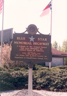
On another interesting note, US 59 from Houston to Texarkana is designated the Blue Star Memorial Highway.
Nasa 1 from Hwy 3 to JSC is also a Blue Star Memorial Hwy.
Many highways are designated this to commemorate military veterans
I am sure there are others in Texas too but i could not find a Texas list online
http://www.fhwa.dot.gov/infrastructure/blue01.cfm
-
I would like to see something like this in the Houston metro area.

It has been that way for several years on 225 and I-10 East.
-
I'm gonna miss the H-E-B...it's the last HEB Pantry I know of.
Also, you can drive to Alvin or Baytown to get the Pantry Experience!
-
Does anyone remember A&P supermarkets? I can vaguely remember going to one in the early 60s when I was a kid. I remember they gave PLAID trading stamps. Maybe if someone has access to a Houston Yellow Pages book, they can look up where they were located. I could probably pinpoint the one I went to way back then. It was between 1960-65.
Here is a list from 1956:
General Offices: 7800 Washington
Stores:
5006 Bellaire
2420 Crawford
2900 Luell
6735 Richmond
813 E. Shaw (Pasadena)
2930 S. Shepherd
4965 South Park (MLK)
5305 Telephone
8213 Long Point
-
Yeah, I remember the Riverside which was on a bluff just north of I-10 in the Four Corners area. Magnolia Gardens was further up the river. It did burn down, but I can't remember when. Very popular place.
i believe Riverside Inn was right here:
http://maps.google.com/maps?f=q&hl=en&...&iwloc=addr
On River road just north of 10 on the main river channel. There is a store and boat ramp still there or there was several years back.
Could you be thinking about Tugboat Annies just north of 4-corners on 2100?
-
I don't see any threads here regarding Magnolia Gardens which was, for years, a popular music venue where country-western acts as well as early rockers like Elvis, Carl Perkins, Jerry Lee Lewis and Johnny Cash played often. The place sits on the San Jacinto River, I thought in the Cloverleaf/Channelview area north of I-10, but I believe that it is actually north of old Highway 90. The old memory is pretty unsteady about this since I haven't been there since about 1973 or so. It had a big open-air dance floor and bandstand in its heyday.
When we would fish the San Jacinto, my dad liked to motor over there in the boat and talk about all the people who played Magnolia Gardens. By that time (the 1960s) I remember that it had a restaurant/club that overlooked the river and they used to have boat races. Singer Rodney Crowell wrote about seeing shows there on his 2001 album The Houston Kid (which any HAIFer who prowls the history board should have).
Any memories, relics of the place?
Magnolia Gardens is off of Garrett and Sheldon rd North of (old) hwy 90
http://maps.google.com/maps?f=q&hl=en&...055275&z=14
No memories other than when it was a place to go swimming at the river and seeing people swimming there when we skied by. (80's)
I always heard it was a big deal with the Big Bands in 40's and 50's (similar to Sylvan Beach).
-
Has anyone ever been to Burger Park?
It's on MLK (aka south park) just south of 610.
-
Can any provide background or information on the brick building on the northeast corner of Wayside Dr. and Harriburg Blvd. which used to be an old telephone exchange for Southwestern Bell? As early as 1925, the property had some kind of telephone exchange structure on it according to some old Sanborn maps.
The building is solid and looks structurally sound but I see no traffic entering it. Is it currently being used for something?
I imagine it still holds all the circuitry for all the phones in that part of town. (Central Office - Wayside Exchange)
Most of it is automated now, so there wouldn't be a reason for a lot of people to go in and out of the building.
-
-
Reminiscent of a recent favorite of mine, Richard Nickel's Chicago.
I love his work and like doing similar things, but have to remember he died doing it

Thanks, Sev.
It turns out I already have this book in my Amazon.com Wish List from April 30, 2007!
I guess i need to make more of my wishes come true!

and yet more info for people that like this kind of thing:
There is a great website on NY that, several years ago, I used to read religiously:
there is also one on Detroit that i remember looking at before too
-
wow, that photo is something else. If that doesn't say 'end of empire' I'm not sure what does.
If anyone is interested in similar photography of decaying urban cities...
Check out one of Camilo Jose Vergara's books. American Ruins includes a photo of the above former Michigan theater among other similar photos from other cities.
also check out:
Unexpected Chicagoland.
-
House of Pies -
The Dutch apple was very good
The pecan was very very good
The coconut cream as TO DIE FOR!
3 pies = $31.00
just curious..i am a big fan of coconut cream pie,
is their's topped with meringue or whipped cream?
-
a little history from GHPA
http://www.houstondeco.org/1930s/settegast.html
thread on it:
http://www.houstonarchitecture.info/haif/i...?showtopic=4739
-
btw...found this in the google LIFE pics. It is a nice July 1952 picture overlooking the Shamrock Hotel pool. The Prudential Building is in the background with its large gibraltar logo.
http://tbn0.google.com/hosted/images/c?q=1...404d650f0_large
-
1
-
-
West Gray is approximately 11 blocks from City Hall, at its closest point.
oops...i just realized my typo...i meant West DALLAS! duh!
anyways.. after seeing this picture i think changed my mind to allen pkwy too
you are probably right about being too primitive for w.gray (meant DALLAS - sorry)after looking at THIS picture..i think it Buffalo drive/Allen Pkwy...maybe that part just past the Sabine bridge in the background
-
I strongly "urge" everyone reading this to visit the Flagship Kroger on 59/Kirby. When I enter I walk in with a confidence that it will be a pleasant experience and it always is!
I think you must mean the Kroger at Buffalo Speedway and Westpark.
There isnt a grocery store at 59/kirby that i know of.
-
I was reading the Chron's blog on historic Houston, when I came across this picture of JFK touring a NASA facility listed as being at "6040 Telephone Rd". Does anyone here remember that facility? According to Google Maps, there's still an industrial looking building standing there, perhaps the same building that housed the facility. I don't know what it houses now though.
it's the Ambox bldg.
check out the thread here:
http://www.houstonarchitecture.info/haif/i...?showtopic=3080
and this thread for info on the telephone road book with a chapter on early NASA
http://www.houstonarchitecture.info/haif/i...showtopic=14855
-
found these addresses out of an old phone book
1226 W. Gray
Todd Decorationg
3400 Montrose
Southern Insurance co.
-
Don't forget Fox Photo! They had parking lot kiosks too!
-
Memorial Drive. I remember reading something on the history of Otto's on Memorial when I was there - when they opened in 1950, Memorial was still a dirt road. That looks like too primitive a roadway to be West Gray at that time (and there would have been development along the street, not trees) and surely the street in front of the Sear's store on Buffalo Drive was more improved than that 17 years after it originally opened. The dip in the background would be about where the Police Memorial is off to the left, I think.
BTW, great pics, tmariar, thanks for the post.
you are probably right about being too primitive for w.gray
after looking at THIS picture..i think it Buffalo drive/Allen Pkwy...maybe that part just past the Sabine bridge in the background


Humble Oil Company Skyscraper History At 800 Bell St.
in Historic Houston
Posted
but today it's actually the downtown spur...the part that goes over s. main and comes around by the GRB hasnt been built yet.