

JLWM8609
-
Posts
2,418 -
Joined
-
Last visited
-
Days Won
4
Content Type
Profiles
Forums
Events
Posts posted by JLWM8609
-
-
I'm not sure, but I rode by it today. It's 2615 Riverside Dr.
-
My high school no longer exists. It was called Middle College For Technology Careers High School (whew! I hated telling people where I went to school because the name was so long and nobody had really heard of it, so we called it MCTC for short). I was there from 2001 to 2005. It was orginally located somewhere on the southwest side, then relocated on TSU's campus in the late 90's. It was VERY small, only 300 or so students at its peak. It was in the technology building, then beginning with the Fall 2001 school year, which is when I began, they'd moved into the old George Allen Building at Tierwester and Wheeler. It was less than a block away from Yates, and once there was an "attack" on some of our students from a gang of guys from Yates. Some "he said/she said" mess started that. The building was in serious need of repair, for a technology high school, we had some mighty old desks and computers. Ceiling tiles were missing. It was cold in winter and at times, the AC would stop working when it would get hot out. The basement would leak, and the walls had cracks in them. I graduated in May 2005 and was gladly looking forward to college. HISD finally realized early on in the Fall 2005 school year that the building was unsafe and moved it to share a building with a middle school in one of the hoods south of the South Loop East. After Spring 2006, the school merged with Wheatley High School. This meant a brand new building, state of the art technology, etc... But, it was now Wheatley, no more MCTC.
-
 1
1
-
-
Now thats a good question. Who is paying the taxes?
I thought for sure there was a cemetary section on this forum and this would get shoved in there.
On a seperate note. Does anyone know what the name of the little cemetary is on Lockwood and 610 frwy?

They finally cleared it a few years ago and placed a white fence all around it. It was also neglected for years. Now that one has to be historic big time!
Its across the street from Cozy Kitchen Barbecue and over a few blocks by 610.
If it's by Cozy Kitchen, that's I-10, not 610 that it's near.
-
It's not uncommon to see homes go for over $600k, or even $1M.
-
The deed records for the cemetery metion a 20 foot wide road for access to the cemetery from the public road. Has anyone seen any evidence of such a road. It could even be on the S. MacGregor side I suppose.
I can look again tommorow, but I didn't see a sign of that road.
-
Just some photos of some mods in Riverside Terrace that I really like.
This one here's on N. Roseneath, built in 1947.
And this one is on S. Parkwood, built in 1950.
-
1
-
-
Does anyone know of ant hauntings in that area? I worked for a TV atation a few years back and we did a story on some house in that neoghborhood that the neighbors claimed was haunted. However I cannot remember which house. I do know it was off of N. MacGregor. If I see it again I will remember. I have to take a drive by there tomorrow.
BOO!
I believe I know which house you speak of. It's not on N. MacGregor though. I think it's on Ennis, Calumet, Live Oak, or Riverside.
And yes musicman, I think these will either be high priced condos, or high priced gated housing like the nice sized houses behind those gates and walls on Dixie Dr. right next to 288 and Grocers Supply.
-
My grandfather used to drive 18 wheelers for Weingarten's. He drove them until he was 69 years old, so that was around the 1981-1982 timeframe. Before that, he did some other work for Weingartens. My uncles worked in the stores too, I know for sure one worked at the Almeda Rd. location where the post office now sits, and my grandfather and other uncles at the N. Main location that's now an auto parts store.
-
LOL don't go to memorial often?
Nope, in fact, except for going to the Aboretum once when I was a little boy with my dad, I can't remember going into Memorial Park. Don't think I'd venture in those woods alone either (or their restrooms for that matter), did I just say that?

-
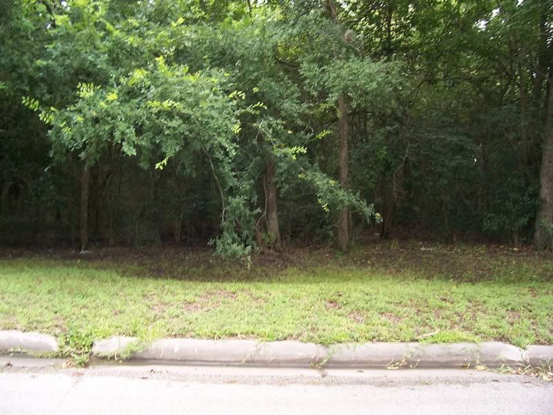
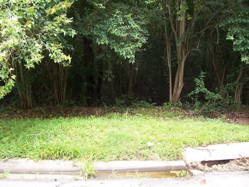
Photos I took today of the site.
I don't know if there are any headstones or other markings out there, but I'm not one to venture into the woods alone in the inner-city. Though I've heard those woods were used as a makeout spot (I presume other "activities" as well
 ). My now deceased oldest brother even found someone's stash of dirty mags there once. And nobody until now knows that it's a cemetery. There is a small waterway running though there. A pipe running under Roseneath terminates on that land and is probably the source of that waterway. The land is not your typical Houston flat, there is a slight. natural roll to it. There is also some evidence of illegal dumping in the guise of tires, empty motor oil bottles, etc... I think some sort of signage should be put up denoting the cemetery's existence.
 -
So I suppose that's the family "Kuhlman Gully" was named for. I'm also trying to make out some of the words on the map. Looks like Griggs Rd. had lots of other names back then, I see "Brays Bayou Road", "Road from Houston, Galveston, and San Jacinto R.", "(can't be read) Crossing to Pierce Junction and Houston Road", and I also see a section of land is named after someone named "Tierwester", another interesting origin of a road name.
-
I have heard some rumors of a cemetery in this neighborhood. What I was told is that it was in the vicinity of S. MacGregor and Bowling Green, but I can't back that statement up. Maybe I'll get a chance to ride over on Roseneath and see what I can find.
-
1
-
-
The house is in the process of being demolished as I type. If you want your photos, get them ASAP. Half of the house is gone now, I except it to be fully demolished by this evening.
-
Sadly, I believe it is too late.
-
I heard that the last owner of the house was slowly restoring the house to its 1939 appearance, when it appeared in Architectural Digest. UT completely gutted the house shortly after they purchased it in 2001, in order to remove asbestos (rarely found in large quantities in pre-WWII residences). I agree, very sad end to this beautiful home.
It is a shame that Houston is still losing the large homes that line the MacGregor Parkway. I was very distraught when that church on North MacGregor demolished that beautiful Mott house, along with two neighboring houses in 2001. The building that is now on the site is out of scale with the neighborhood and very poorly detailed on the exterior.
That church is Good Hope M.B.C. The houses on that lot were once for sale and to be moved to another location after being bought. But nobody ever bought the houses, so they demolished them. The large building on that site now houses the church's reception hall and school. It matches the church and the landscaping's nice, but it's the first time I've seen a reception hall type building bigger than the church! I think it also houses offices for church staff.
-
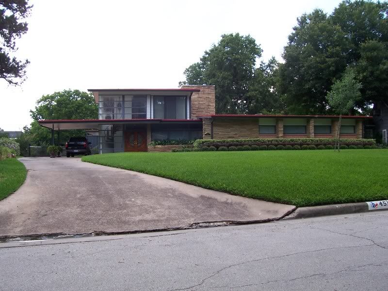
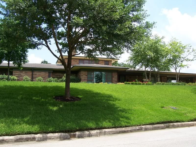
The old Wright Morrow Estate at 3028 S. MacGregor will be demolished soon. It was originally bought from it's former homeowner in 2001 with intention of the land being used by UT to build a four story Psychiatric outpatient center. Residents in Riverside Terrace fought the project and suceeded as it would bring high traffic and noise into the neighborhood. The land was put on the market again and purchased by a developer to put high dollar condos on, perhaps gated. Some relatives of Wright Morrow were allowed to remove some of the old furniture the other day, I saw them taking it out. The house appears to be gutted now, and some shingles have been removed from the roof. The house has been in disrepair since 2002 shortly after UT bought it. The previously meticulously manicured gardens and lawn became overgrown, the white fence bordering the estate started to fall apart, and the exterior paint on the house was peeling off. A sad end to a beautiful estate.
-
1
-
-
Does anyone have any information on this deserted mansion at 5130 S. MacGregor Way?

I live not too far down the road from this one. It is VERY flood prone, also a little interesting rumor I've heard is that they filmed some "adult" stuff in there back in the 80's.

The reason it's deserted is people have moved in, a typical big Houston rainstorm comes in, flooding occurs, they move out. The next person moves in, unbeknowst to the flood threat, they get flooded and move out. I guess potential buyers finally learned about the threat, and there hasn't been an occupant there in 3-4 years. The flooding doesn't happen because it's next to the bayou, but it's built on low terrain. In fact, before they straightened out Brays Bayou for the first time in the 20's, Brays Bayou was a meandering bayou complete with oxbows, in fact, you can still where it flowed where current day Parkwood Park is and look at the terrain in the neighborhood, how it's kind of "hilly" compared to other sections of town, especially around Rio Vista and S. MacGregor, and S. Parkwood and N. Parkwood. Either the house sits on the old banks of the bayou, or perhaps it used to run through there. Old Houston maps from the teens and 20's will show that.
-
To adapt to the changes that have occured in vehicle design thus enabling higher speed operation the roadways must also be changed.
Do you think putting jet engines on aircraft was a bad idea? Props are what flew out of airports all over the world first so was building longer runways to accomodate faster jets also a mistake?
I understand where you're coming from, but the jet engine/prop analogy isn't very valid in this particular case. Of course jet engined aircraft needed longer runways, they had higher takeoff speeds and higher takeoff weights than thier prop counterparts. Cars do not have to be at a high speed to handle a curve, they can slow down and adapt to the road design without crashing.
-
1
-
-
When it came on PBS, my father taped it, so it's somewhere on VHS here in the house. I'd like to see it again as well.
-
The major failure was in the ramp that takes you from 610 north going to 59 south. Before they reconstructed this area that area of 610 right in front of the Home Depot was famous for wrecks. I still see the area jammed up at all hours of the day during the work week. They did improve the access to go to 59 north but the 59 south ramp seems to be too narrow and sharp for large commercial trucks and SUVs to take at high speed. Even when the traffic is not heavy people slow down to 25-40 mph on that turn.
They should have built an exit ramp like the ones they have at beltway 8 and 59 north where it is a very lazy and gradual curve with lots of shoulder room for people to feel more safe about not hitting the wall. This curve should have gone over the old existing 610 bridge that goes over 59. The exit for the ramp should have been at least a mile before the actual exit by raising a wall protected with crash barrel to keep people from jumping on the exit at the last second and causing more slowing.
With that intersection being in the top 10 more busy and dangerous in the USA the sky should have been the limit on funding a good solution.
Design standards were different in the late 50's when the interchange was designed. Cars were bigger and slower, and people didn't barrel down them like they do today. I don't see anything wrong with those ramps today. Solution is, if you're driving a big rig or a SUV or a car that can't handle sharp curves at speed well, slow down! That's why they're going 25-40 mph in light traffic. If you crash going through it, it's your fault, not TxDOT's. They have signs telling you to slow down. It's all part of being a responsible driver.
-
1
-
-
I found this photo taken on November 21, 1963. The Lincolns (I also think I see some Mercurys) in the foreground were used in President Kennedy's motorcade when he came to Houston that day. I've been looking at that photo to determine where it was taken. It looks like it's in front of a Lincoln/Mercury dealership, it might be Shepherd or Durham since it's a wide, one way throughofare, but it curves a bit in the background sort of like coming off the terminus of a freeway, or it could be somewhere downtown before the modern skyscrapers were built. I see a church in the background, it looks very familiar, but I know of a few churches in the area with similar architecture. Any of our resident historians want to take a guess as to where this photo was taken?
http://www.cah.utexas.edu/db/dmr/image_lg....iable=e_bb_2644
-
Did anyone on this board go to Samuel Clarke (S.C.) Red Elementary located near the Willow Meadows and Willowbend subdivisions at the intersection of Tonawanda and Cliffwood? They had a celebration today commemorating the school's 50th anniversary. Teachers and principals were there from the past and present, even some who taught during the early years in the late 50's, with scores of alumni.
-
Is the Weingarten House located down on S. MacGregor?
-
I think most of the UH campus faculty members who live in the area live in the houses off of N. MacGregor between Cullen and Calhoun, I think that section is called University Oaks? To show how university oriented that section is, they have a Faculty St.


Historic Houston Schools
in Historic Houston
Posted · Edited by JLWM8609
I was at Longfellow for a short period of time in the mid 90's. Is Mr. Beringer still principal?