

004n063
-
Posts
1,006 -
Joined
-
Last visited
-
Days Won
1
Content Type
Profiles
Forums
Events
Posts posted by 004n063
-
-
On 4/3/2024 at 10:35 AM, steve1363 said:
"I think we need to have common sense, and I think the bikers need to be protected from the traffic, and they need to do that on bike paths that are recreational and not try to compete with people going to work and school,"
As a bike-commuting teacher, this kind of statement really makes me want to walk into the ocean
-
 4
4
-
-
18 minutes ago, steve1363 said:
You have a way of making excuses for Houston's lack of walkability, bike lane usage, transit usage - usually blaming city leadership. But isn't the reality what Cuevas said (although I know he would disagree on bike lanes) "People are making this a big deal but Metro is always adjusting service to different routes based on overall demand."
Dallas has a similar issue... much more extensive LRT than Houston but just not enough demand.
I don't think I'm making excuses. I simply explained why nobody with any transit knowledge would have expected the Silver Line to be a high-ridership line. Anyone with high expectations was kidding themselves.
The University Line would be a replacement and upgrade for the heavily used #25 Richmond line in conjunction with the 153 Harwin express bus.
It's also a line that seems much more likely to experience a significant increase in ridership after its introduction than the Silver Line, due to the high-value corridor from Greenway to Wheeler. A bus that comes every six minutes, doesn't get stuck in traffic, and connects to the Red line has much more appeal to the general population along the corridor than the current bus, which already gets a lot of riders.
-
3
-
-
There's no question that the Silver Line was not a great choice of route for a flagship service (though my recollection is that the project was more of a TIRZ-led project than a METRO brainchild?), and they flubbed plenty of details when it came to things like stop location/spacing, signal priority, and frequency.
Combined, they made the paltry ridership numbers unsurprising to those of us who are deeply interested in transit functionality.
But that's a very small number of people, and @j.33's concern is spot-on: as the University Line gets ready to begin the years-long, expensive, highly visible, and traffic-slowing process of constructing the line, it's almost impossible to imagine Whitmire not trying to intervene, and an underperforming Silver Line is an easy tool for that objective.
-
1
-
-
4 hours ago, Diaspora said:
There’s much yet to be realized as Midtown grows to confront its potential. For instance, the newly reconstructed segment of Caroline Street, while engineered well (enough) and being future-forward will, without more, simply be a multi-million dollar road to nowhere unless there are incentives and arrangements to bring retail and vibrancy to the stretch between Gray and Elgin. Moving strategically and providing placemaking interventions that bridge Caroline to Main will assist in addressing the blighted strip along Fannin and San Jacinto. Using increment and assessment to invigorate retail and ensure clean and safe pathways for residents and visitors — set as a priority — will enable the cultural nodes that are now languishing to flourish. Smart, surgical employment of enforcement and engagement resources, on foot, and capable of enforcing City Ordinances (sorry Constables that means you’re best deployed elsewhere) will go some way toward enlivening Midtown. We don’t need more parking but we would benefit from a precise parking guide that visitors could access to enable ease of access. Midtown boasts some of the best parks inside the loop. These should be activated/programmed regularly and consistently — with more than exercise classes. Use Levy Park and Market Square Park as learning tools for activation.
All I want is CDMX-style carts in all of the parks. Not sure if it's a demand problem or a regulation problem, but dammit I want a torta with salsa from a bucket.
-
2
-
-
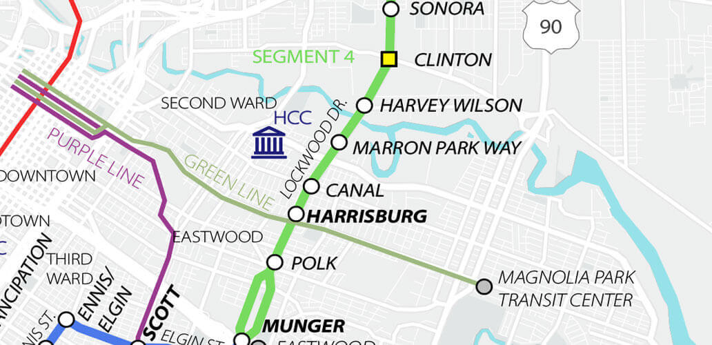
4 hours ago, j.33 said:
METRO also calls it Marron Park Way on their University Corridor alignment map.

I so want to believe that the University Line won't get axed...
-
1 hour ago, IntheKnowHouston said:
Based on the site plan, it appears there is:
-
A parking structure for 174 cars
-
Surface parking fronting N Palmer St; 88 cars
-
Surface parking along Commerce St; 91 cars
- Surface parking along Canal St; 85 cars
🤦
-
A parking structure for 174 cars
-
"Exposed" brick on the inside. This whole building is so slightly weird.

-
4
-
 1
1
-
-
On 3/13/2024 at 6:24 PM, hindesky said:
Drive Thru menu, it's not open yet but looks like it will be soon.
Birria being a famously car-friendly food.
Then again, Salads-2-Go or whatever is is springing up all over, so what do I know.
-
 1
1
-
-
Still far too many parking lots throughout the district, but there are some nice residential pockets (the area that stretches a few blocks north and west of Elizabeth Baldwin Park is really lovely) and mixed-use pockets (Mid-Main and its more oil-bro cousin, Bagby), but there's just too much wasteland in between.
That, combined with the highway-lite designs (and accompanying vehicular speeds) of Crawford, San Jacinto, Fannin, Travis, Milam, Louisiana, Smith, and Brazos, and the unpleasant stroadiness of McGowan, Elgin, and Alabama, makes Midtown's continued listlessness unsurprising to me.
Throw in a high concentration of shelters and recovery centers and you've got a recipe for a place that's hard to dynamize.
Housing is generally affordable, but I would personally prefer that as a consequence of oversupply, rather than suppressed demand.
-
4
-
-
Corner of Preston and Caroline
-
2
-
-
10 hours ago, Ross said:
We live inside the loop.. We have a 1/4 acre lot and live within a few blocks of Kroger. We still use the car to shop for groceries. Anything to do with the yard is going to require a car. I've known a few people who tried to live without a car in Houston. One managed pretty well, but he was a coworker who was literally a rocket scientist, but was absent minded. He never learned to drive. All the other gave up after a month or so. The other issue is getting to and from work. Unless your office is downtown, public transport is tough. When we lived in Midtown, I had to take the bus to Bellaire for work for 6 weeks after TS Allison flooded my car. 6 block walk to the bus and it dropped off across the street from my office. It turned a 10 to 15 minute commute into 45 minutes or longer. Why would I not use a car for that?
I've been without a car for a year and a half now, and while I'd never consider buying one again, I think it's silly to scold people for using cars in a city that consistently makes cars the easiest option for many tasks.
The goal should be to consistently cut into the overall automotive modeshare by making alternatives viable and appealing. If people who used to drive for everything now drive to the grocery store, home depot, and work, but bike to coffee, the bookstore, and school, and walk to the park and the bar, then that's a win.
More importantly, though, like another commenter said, this has nothing to do with the 11th street bike lanes.
-
3
-
-
22 hours ago, ChannelTwoNews said:
This is actually a pretty good review of the situation up to January, when the transit board had to decide on reinstating fares.
Free bus rides in Kansas City need more dollars to continue | Kansas City Star
"RideKC buses and paratransit vehicles have been a free ride since March 2020. Now the temporary federal money that made that possible is running out, and local officials are at a loss for who will foot the bill. Might this mean the end of zero fare?
That depends on whether the Kansas City Area Transportation Authority can close a $10 million gap with new funding from local, state and federal sources. They have no assurance that the money to keep rides free will be there in 2025.
The KCATA made that clear late last year when it raised the possibility of needing to reinstate fares, which led to a groundswell of public support for keeping transit free.
But what’s been left out previously is that the KCATA might have had a cushion to assure at least two more years of free fares, had Kansas City’s government lived up to its promise to fully fund its share of the program."
A few days later, the board voted unanimously to continue study fare reinstatement.
KCATA board votes unanimously for further study on bus fare plan (kmbc.com)
As a general rule, I'm against fare-free transit. While I think transit should be heavily subsidized, and people who need free rides should be able to get them via some kind of process, I think transit agencies need revenue streams that aren't subject to mayoral whims.
-
2
-
-
Hard to imagine a worse land usage to front a rail stop than a car dealership, so I'm pretty optimistic that whatever comes next will be an improvement.
-
7
-
-
- Popular Post
- Popular Post
7 hours ago, steve1363 said:The fundamental pain point is the opposition’s voice was ignored and hence why we’re still discussing this 6 months later.
I'm not ultra-close to the 11th project, but this statement - along with similar ones about the Montrose Boulevard project - is deeply frustrating to me.
Do people not realize how insanely hard it is to get anything done for non-drivers in this city? It took six 311 calls to get the knocked-over school speed limit sign outside of my school moved a few inches off of the three-foot sidewalk. Not fixed, not even cleared away. Moved a foot and a half.
I know that's a pretty stretched anecdote, but my point is this: every piece of infrastructure built for pedestrians and cyclists is the product of years - usually over a decade - of begging, clawing, fundraising, desperate (and mostly ignored) public outreach, and compromise with the twelve angry NIMBYs who default to opposition on everything.
It may or may not be true in this instance, but the paradigm of bending over backwards to appease every opposing voice has been strangling this city (the whole country, really) for too damn long.
-
11
-
3
-
Update on one of those:
Definitely doing that field trip again next year.
-
2
-
-
2 hours ago, j_cuevas713 said:
I'm hearing that the mayor is getting rid of the Vision Zero program. This will ultimately affect any federal dollars for future projects. It has already affected Phase 2 of the Montrose Boulevard redesign. The feds denied funding because it doesn't provide enough multi-modal access. The city resubmitted the project for funding with no changes. I'm very worried how this will affect projects like Gulfton/Kashmere Gardens and the massive grant they just received.
This mayor just doesn't get it and he's not going to. I voted for a Democrat, and this mayor doesn't act like one. I expect some major changes to 11th Street if not completely removed.
On a positive note, the mayor supports the Quitman bikeway which will have a groundbreaking tomorrow. Adrian Garcia said he met with the mayor to discuss the project and it has his support.
Considering that the teeth of Houston's Vision Zero was basically that we don't super love it when pedestrians die, it would be a pretty wild move to abandon it.
-
2
-
-
9 hours ago, editor said:
I assume you drove there, but do you have any sense of how far it is from the Red Line? One of my doctors might move there, and I'd rather change doctors than have to take an Uber down there. (If I'm visiting this particular doctor, walking is difficult, and driving is not an option.)
It's a 10-15min walk from TMCTC, and not a terribly comfortable one as of now.
-
1
-
1
-
-
I remember at one point the renderings had only the area within the Helix as parkland, with buildings lining the full way. Now I see a surface parking lot and two parcels of landscaped park where buildings had once been planned.
Is this the new permanent vision? Or are they placeholders until they get organic demand for the other parcels?
I'm sure the additional park areas will be nice (can't say the same for the surface lot), but there's a lot to be said for an enclosed park, especially in a city as sweltering as ours. Would be really cool to see residential over GFR eventually fill in those three parcels.
-
1
-
-
So this is more-or-less done.
Cullen Boulevard has been improved from Polk to MacGregor/Brays Bayou. Here are a few "before" snaps from Google Streetview:
The project(s) included protected bicycle lanes on both sides from Polk to I-45 and a complete street reconstruction, including wide, off-street paths (with separate pedestrian and bicycle lanes, at least nominally) from I-45 to MacGregor.
Pedestrian and bicycle treatments were applied to the intersections with I-45 (fantastic):
Elgin (pretty bad):
and Wheeler (very good).
-
7
-
1
-
-
5 hours ago, steve1363 said:
You'd better come up with a better selling point than this!
If we as a city cannot understand the concept of fast cars being bad in certain contexts (e.g. busy neighborhood main streets), then we deserve our doom.
-
2
-
-
I'm not going to pretend that the 11th street lanes were as badly needed as, say, the Austin or Lamar lanes downtown, in terms of providing bicycle access to previously inaccessible areas.
I also don't think that the Shepherd/Durham lanes do all that much of that.
If it were just about bicycle access, then the optimal solution would have been to dedicate some streets - say some combination of 10th, 13th, 15th, 18th, 22nd, and 26th for E-W, and Nicholson, Rutland, Harvard, Arlington, and Micheaux for N-S - as traffic-calmed streets: narrowing, modal filters, chicanes, mini-roundabouts, textured pavers, planters, and crossing treatments (à la Nicholson@11th) for difficult intersections. This is essentially the Dutch concept of ontvlechten, or "disentangling" (different routes for different modes), and when done right it does a lot for bike utility, with a much lower per-mile cost than through-running infrastructure.
That said, neither of these projects (11th or Shepherd/Durham) was or is about bicycle access. These were stroads, and bad ones at that. They were dangerous, ugly, and generally hostile to anyone outside of a car, and they weren't particularly safe for drivers either. The purpose of the projects was to reduce the danger of the streets. That means lower speeds.
The improvement projects won't turn them into perfectly safe neighborhood streets, nor was there ever a real chance of turning any of them into highly efficient (and safe) roads, due to the amount of commercial development along all of them. But because both of them do have a lot of commercial (and, increasingly, residential) development, the move toward streetification makes sense. They need to be safer.
Fast moving car traffic on a two-lane highway with miles between exits can be pretty safe. Fast moving car traffic on a street with many commercial driveways and intersections cannot.
Unfortunately, TXDoT does not really permit the kinds of redesigns that can truly slow traffic, so when that is the goal - as it was for these projects - the best option we have is congestion.
-
3
-
-
8 hours ago, JBTX said:
Like Hindesky said, GFR is ground Floor Retail. My comment about the church is with regards to the prohibition of alcohol/liquor licenses being issued withing 500ft (if I recall) of a church/school. The GFR on the Navigation side of Forth is about 200ft, max, from the church. Arguably it is well outside 500ft of the school, but it would depend on how the church/school plot is drawn up.
Gotta love that you can't have a store or restaurant that sells alcohol on a major neighborhood corner within 500ft of a school, but you can totally have a Westpark Drive + Westpark Tollway monstrosity within 20 feet of a classroom...
-
3
-
-
On 3/11/2024 at 12:38 PM, 004n063 said:
Not a huge update, but a bit more clarity. Looks like pretty standard school fare.
Appears to be done.
-
2
-
-
Looking south fro. Houston@Wrightwood. Brick up to fourth floor surprised me, but maybe it's been there for a while.
-
5
-


Preston/Commerce Corridor Bikeway
in Bicycles and Other Low-Impact Modes
Posted
Interesting. This is an essential route and I really hope it moves forward, but I'm curious about the Preston Street section, particularly between Main and Austin.
Given the current geometry, I'd assume that the most sensible route would be to upcurb the current onstreer parking spots to make the ped/bike right of way continuous from its widest points. But I imagine that that would be contentious.
If they took that approach, though, they could do one-way paved bike paths on either side, which would make it easier to navigate around the trees.
I think any plan to cut down the trees would doom this project, but I'm curious about whether the city would rather go on-street or off-street with the bikeway there.
I assume Commerce will be on-street à la Austin, at least for this section. (I think Harrisburg Trail-Navigation may be off-street, with just a wide, smooth sidewalk like Cleburne, though I base that on nothing.)