

cloud713
-
Posts
4,366 -
Joined
-
Last visited
-
Days Won
25
Content Type
Profiles
Forums
Events
Posts posted by cloud713
-
-
Dammit triton. I've been by 3 times and it's been closed every time
-
 1
1
-
-
wait, so according to this the TMC is now larger than downtown Houston?
http://www.texasmedicalcenter.org/media/files/page/SqFtCityComparisonFall2011.pdf -
Anyone going to the meeting? I think it's coming up next week..?
-
Haha, notice I mentioned moving the prison is key. And yeah, didn't see any mention of it. Maybe the next mayor will have a vision to redevelop that area.. Why have a prison in the middle of a city where land prices are so high? Might as well be a high-rise prison.. Heh. Probably be harder to escape from too.
-
1
-
-
Yeah it's possible at the rate weve been seeing announcements over the last few months that we will hit 5,000 well before the June(?) 2016 cut off.. These are insanely exciting times IMO.. We all want downtown to have that residential base to sustain the bars/restaurants/retail, and it's finally happening!
Edit. The bms market square tower is huge! Didn't realize it had that many more units than Hines market square tower. So 11 projects.. This isn't counting the apartment building just south of SkyHouse is it?
-
I can see how it would work using the sunset coffee house as a base and ferrying people to that area via the bayou
I have always belived Houston has so little natrual beaty that we should be busting our ass to enhance what little we do have.
I can see it too if we can relocate the prison.. (Are there any plans for that?) but with so many other mixed use developments happening across town and large swaths of land like Hardy yards, KGB, and the astroworld site sitting vacant while seemingly prime for development, I don't see the canal area turning into an instant hit unless the city really got behind it with incentives and stuff like they are doing for the residential and retail districts/programs.. Which is entirely possible. I hope that area somewhat resembles the 2003 master plan eventually, but I don't see it happening for a decade or so.
-
Downtown Living Initiative Program
Cap pushed up to 5,000 units, previously 2,500
Now includes pretty much all of downtown
Same requirements, incentives and termination date (June 2016)
YESSSS!!! i was hoping for 5,000. that will TRIPLE the number units that were originally in downtown. i would think the population will be closer to 15,000 than 10,000 if they max out the cap space.
what page was that on, urb?
-
1
-
-
For someone who applauds rail-based mass transit in and around Houston, you sure seem critical of the area to connect lines to the greater metropolitan area.
Now, although business has picked up in the last few years, the 290 corridor has lost a lot of traffic in the last five years (especially around 2009, but now I hear a train maybe three times in an hour--I take classes near tracks, see) but there are less railroad spurs these days. Furthermore, as long as trains run on time and on schedule, with two tracks, a commuter rail could run on one and freight on the other (it is not a "two way street", nor a "this one's for us, that's for you"). However, the Washington Avenue part of the track needs to be dealt with, since it's already double-tracked and is even a quiet zone: and I remember seeing some plan about sinking the rail and/or adding commuter rail in a plan somewhere, so perhaps sinking it (a 500 m grade lowering area between the "Grape Arbor" over I-10 and T.C. Jester to sink the tracks) would be ideal.
that was superneighborhood 22s proposal/plan(?) back in 2010 for the area between i10/Washington to the west, and i45 to the east. trench the whole section of tracks, and add two more tracks in the process for commuter/heavy rail. i wish that would happen.. they also had sketches for a streetcar down Washington into downtown, to the baseball field, and one going south into Montrose, and a potential light rail extension of the east end/southeast line in downtown, west down Memorial Dr, being tunneled through Memorial Park.. a bunch of awesome stuff.
-
im gonna grab some popcorn and let livincinco and editor battle this one out.. you both clearly seem more informed on rail than the rest of us. heh. both very great points! i would totally be down for sharing freight tracks, as it makes my commuter rail vision much easier to implement, but livincinco has a point. when the panama expansion is complete Houston is supposed to have even more freight traffic flowing through the port, and thus regional rail lines (and highways, for the people who dont believe in alternate modes of transit)..
Yeah but the line isn't designed that way. Even though a theoretical commuter rail system would spiderweb-out to points farther out, you couldn't and wouldn't take College Station to Beaumont on a line, just like it would be impractical to go from Cypress to Sugar Land via rail. Remember--Houston would still be the "core".
true, but i just dont see enough people commuting between Houston-b/cs, and Houston-Beaumont to justify it, unless we could completely use freight tracks to minimize costs, and even then i would only run lines to b/cs on the weekends, and have no idea when beaumont would ever need rail transport? i would much rather have that line connect into (or be) the southwest flyer (with an occasional beaumont stop) or w/e that passenger rail line is coming in from New Orleans, that continues on west..
why couldnt you take rail from cypress to Sugar Land if there were a westside express route like through the rail ROW half a mile east of 610, that connects 90A to the Hempstead rail line? but i see your point, its not optimal..
In the case of Chicago, they should try to do the nation's first reactivation of rails-to-trails by rebuilding track.
lol.. trails-to-rails.. didnt see that coming.
From the New York Times article that I attached, but you didn't bother to read.
The program, called Create (an acronym for Chicago Region Environmental and Transportation Efficiency Program), is intended to replace 25 rail intersections with overpasses and underpasses that will smooth the flow of traffic for the 1,300 freight and passenger trains that muscle through the city each day, and to separate tracks now shared by freight and passenger trains at critical spots. Fifty miles of new track will link yards and create a second east-west route across the city, building redundancy into the overburdened system.
it sounds like those 25 intersections should of been built as over/underpasses long ago.. not sure why thats just now happening in a region as busy as Chicago. if Chicago can figure out a way to make room to separate/add additional tracks in its dense core, surely Houston could figure out a way to add more rail along the existing corridors?
-
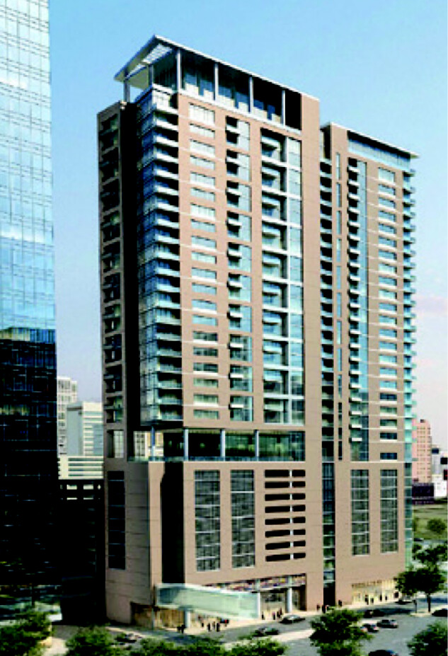
so that is the final design of the first residential tower? i was afraid it would be that curved beige tower.. this one is much nicer looking IMO.
-
1
-
-
i think its saying construction start beginning of 2015. notice the solid black lines? i think those are the year cut off points..
good news though, looking forward to another crane in the sky next year! -
I don't see mass transit as a way of relieving traffic, I just see it as an alternate mode of travel that will be quicker than sitting in traffic on the highway.. Highways should continue to be reworked as long as possible. But widening of roads can't go on forever.
-
That's what I do... first I lure you in with my wit and charm then I pull the rug out from underneath and confound and confuse! Like Zoro, but I don't have a sword!
What did I not hit the nail with in my post? The InterCity to-from BCS-Beaumont through North Houston?
Yeah pretty much that. And not extending the 288 commuter rail down to highway 6.
I don't see the ridership being high enough between b/CS, Beaumont and Houston for that line to make sense.. Do that many people really commute or travel between those cities?
-
yeah i would think so.. i wonder where they got that impression from. a lot of optimism in that list...
-
^I agree! Rail should run to College Station/Bryan, Beaumont and then beyond. I'm thinking you could almost run that as a seperate line. Think Bryan-CS-Navasota-Tomball-Downtown-Aldine-Baytown-Liberty-Beaumont? Why not? Smaller stops (like Navasota) could be a small parking lot (for maybe 100 cars and some bus transfers) and a small covered area with some pay-to-use restrooms (like a buck or something)? Or just don't stop but 3 times a day at Navasota/Liberty etc.?
End points for furthest commuter rail would be:
southeast - Galveston (the Stran)
east - Baytown (link with above commuter line?)
northeast - Porter
north - Conroe
northwest - Cypress (as far out as Fry)
west - Katy Mills
southwest - Rosenburg (FM 762)
southcentral - Pearland (FM 518 - Pearland Town Center)
dammit arche, you were hitting all my thoughts spot on on every post before this one.. haha.
The way I see it, if we're talking about Houston commuter rail, the whole group of Houston-influenced areas should be included, especially as growth grows in those directions. I am also an advocate of using what you have. Existing freight tracks go toward The Woodlands, and toward College Station, and even to an extent Sugar Land. Direct connections do not exist for Westpark, Katy, or Beaumont.
In planning for commuter rail, they should minimize transfers as well. In Denton, in an effort to mirror the East Coast cities with their "superior" mass transit, you take a train to the Trinity Mills station, then ride another 20 miles on light rail to downtown. Now we can quibble about how light rail shouldn't run out to the suburbs, etc. but the point is, transfers should not be required. Notice in my "Northwest Line", a transfer to Northwest Transit Center and the Uptown line is needed only if you were going to Uptown. You could then take that line to go east to downtown, but why would you want to?
Likewise, there would be a "North Line". There would be an airport stop at Rankin and Hardy with a shuttle to the airport (an elevated median on Rankin just for the shuttles for would be pretty sweet, and there you have your "airport connection" rail). Spring station is Cypresswood and Hardy or closer to Old Town Spring, The Woodlands station is at College Park, and then finally Conroe. This would be relatively fast as it is a straight section of track that goes through several communities.
The Gulf line would require a turnaround just south of Nance Street so that it swings around and goes on the track that's in EaDo. Eastwood station at McKinney and Milby, Pearland, Alvin, then Galveston. Between the Gulf Line, the North Line, and the Northwest Line, that would connect a vast area with rail transit...and it's all done with pre-existing ROW except for maybe 4 miles.
well yeah, using the freight ROW is ideal (and is the ROW i tried to follow in most all of my commuter lines in my "ideal transit plan"), but in most cases the freight lines are at capacity so new lines would need to be built along side the old ones, which costs money..
-
The prosecution rests, Your Honor.
----------
Anyway, commuter rail! One thing I think if there was commuter rail in Houston, it should not only go for the suburbs that are just outside of Houston (Sugar Land, for instance), it should go across the entire greater area Houston sprawl. It should terminate at Conroe, Texas to the north, for instance (not The Woodlands), Beaumont (in regards to that versus College Station, the College Station-Bryan metro area is a lot larger than Beaumont's, and the miles of rail from downtown are about the same as well), and Galveston. The "terminal points" wouldn't have daily service, but they are connected in with the network.
i agree about an extension to Conroe (which i would have trains going to at least once in the morning once in the afternoon each day, maybe more often.. especially if something huge goes down at Camp Strake. but i still dont see the viability of commuter rail to B/CS or Beaumont (which is the larger metro, as arche pointed out) unless you were able to use existing freight tracks. and even then i dont see service to Beaumont being viable, and only see weekend service to B/CS.
-
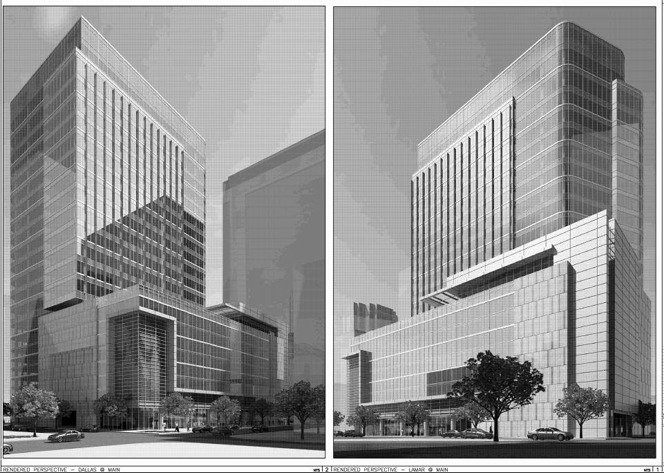
New design:

is it just me or does that look like GFR? its definitely not a garage entrance, and seems way too big (and has two separate locations) for a residential entrance or a leasing office. and speaking of garage entrances.. i dont see an entrance for the garage. unless its on the north side which would be kind of weird because thats where the LRT is going. i guess they may end up linking garages like someone suggested.
-
it looks to me like the concrete in that 2nd picture a few posts up pretty much mimics the towers footprint, minus a little of the garage (i guess either the entire garage doesnt need a foundation, or more likely, the underground level below the garage doesnt extend out to the edges/outer perimeter of the garage above.. [in the northeast corner]).
and yeah, that "core" middle thing was weird. at least how they had the rebar shaped.
since people are too lazy to click links.. lol
Main street side with ground floor retail
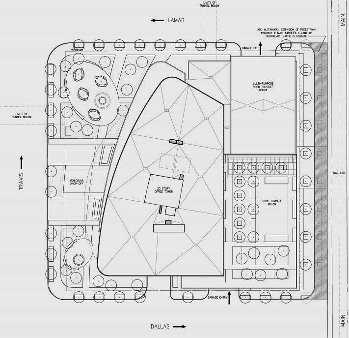
did anyone else notice this..?
"extension of pedestrian walkway if Main Streets 1 lane of traffic is closed".. maybe that idea to close main street to traffic was more serious than we thought? -
well didnt TEMA always say they planned on building 3 towers on this property? this would be the second..
and i am SO GLAD they didnt change the twist design for something cheaper.. -
we discovered a series of neat old cantilevered concrete docks along the river yesterday that provide pretty nice views of the stadium.. (we never really wandered to the west before, by the Texas Ranger Museum/behind the grave yard.. we mainly just go behind the law school, so i cant say the docks were too hidden).
-
the giant podium.. which is 3 stories that arent included in the 50 story count (at least not in the renderings). and/or Chevron tower takes up a large chunk of the block compared to 609 Main being half the block.
-
If I'm playing SimCity, I would skyconnect a re-re-renovated Greenstreet to a renovated Park Shoppes (Houston Center) via a Highline absolute knock-off, type steel stucture going over Fannin north from Dallas and turn east down Lamar to arrive at the Southwest corner of San Jac & Lamar (there's a tunnel entrance there too). Killer app: water features (and could also be a sidwalk below landscaping feature).
that would be awesome.. or if it was from roof to roof, from the top of Greenstreet (which would all be converted to a park, in keeping with the grassy area on the roof they had in front of the hotel in the renderings), over to another potion of the newly converted park on the roof of the HC downtown club, and finally over to the roof of the shops at HC, which could be the final piece of the park. like you were saying, throw some water features in there (there could even be a stream that flowed down from the shops at HC to Greenstreet since the roof of the three buildings step down a little bit each time), maybe portions of the bridges with glass floors to look down at traffic on the street below.. just little stuff to keep it fun.
TBH, i dont see two competitors interlinking their developments, but maybe im wrong. or maybe Midway ends up buying the HC and connects them? heh..
a much more realistic connector solution would be a skybridge from GreenStreet to the HC downtown club, which then has a skybridge over to the shops at HC.
-
hey urb, any idea what the highlighted block next to the Nau that isnt lettered is? on the skinny block in front of Minute Maid.
-
yeah ive definitely never heard of them closing the street. thats one of the streets the east end wants to use for their streetcar system/spur into downtown.


Office Building At 3501 Main St.
in Midtown
Posted
Let's not forget the Almeda Road-Crawford corridor
This.. The two Mosaics, the Spires, the new development planned next to the spires, the parklane, and the new tower at hermann place are all a good start to bypassing those 2 areas..