

cloud713
-
Posts
4,366 -
Joined
-
Last visited
-
Days Won
25
Content Type
Profiles
Forums
Events
Posts posted by cloud713
-
-
That will also serve as a construction cam for the 500 Crawford apartments and the Texaco renovation.
And since no one gets CSN Houston, we can use the link watch the Astros home games if the roof is open!
wow.. you will also be able to see 6HC, 1800 Texas(? the 28 story next to 500 Crawford), the 38 story residential next to the Hess Garage, Marriott Marquis, and possibly the new convention center garage if MM doesnt go up first/block it. what an angle!
-
You don't think Hines market square tower would peek out from the right side of I.T.?
And I don't think it looks bad in the skyline..
-
true, something along 635 from 75/the red line, west to PGBT, turning south down PGBT to the LRT line running towards DFW, ending at the Belt Line Station (Orange Line?) would be great. it would also connect into the line going up i35 towards Denton (Green line?). most of DFWs population is to the north, so an east/west connector on the north side would be ideal to prevent people from having to take unnecessary trips into downtown when they are trying to get somewhere to the east or west.Dart really needs something that goes east west. Right now it's mostly north south.
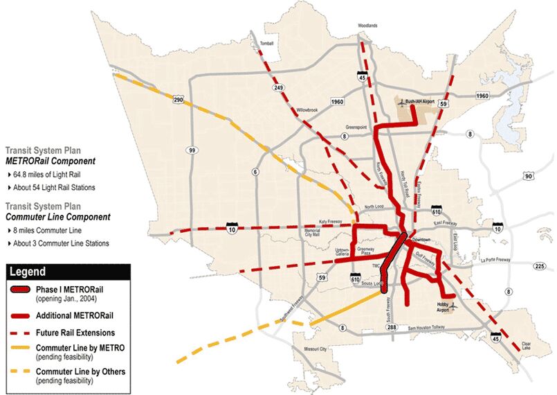
here is a comparison of the map METRO is trying to build, and some future map that i dont think they are trying to fully accomplish anymore(?)..

i dont understand the line paralleling the Red line to the east, going down into old Pearland. i would of put the line down the middle of 288, but i guess at the time there were more people along the corridor they selected, and 288/new Pearland wasnt exploding with population growth as much. i would scrap that southern spur/branch off the southeast line, and jump the red line over on Belfort, for a southern extension down 288 through Pearland and possibly all the way to the P&R at Highway 6 (though thats outside of Harris County, so another agency would have to take that portion over i guess?)
-
 1
1
-
-
That block is parceled up between 5 or 6 unrelated owners.
Damn. I guess it makes sense given that there are multiple separate buildings and parking lots on that block. Maybe midway could make an attempt buying up the majority of the block and building around the holdout(s), a la Hines Southmore.
-
Demo will continue through the end of the year?!
-
I didn't think that DART screwed it up at all. At least their Red Line (northeast to Plano) seemed to get pretty good numbers at non-peak hours. It's not crammed--I consider it a major problem if mass transit lines like rail are just as congested as the highway. I don't know of any other lines beyond that, though, so perhaps that line isn't the best indicator.
I also don't think as far out as Galveston is really effective as a commuter line unless we went with a full "greater Houston" type rail network as discussed earlier. For what it's worth, here are some rough calculations of distance from the city center (measured in miles). As you can see, Galveston is much farther away than other Houston area destinations.
Sugar Land - 20 (existing rails are problematic, that's "as the bird flies")
Baytown - 24 (existing rails may be problematic, so it would be much longer)
Cypress - 29 (Fairfield area, using existing rails)
The Woodlands - 30
Conroe - 40
Hempstead - 50
Galveston - 50
Beaumont - 83
College Station - 90 (despite being far away, it hits a number of other stops, and as time goes on, a connection will be more important)
Orange - 105
Conversely, Denton over in Dallas is 35 miles and requires one transfer to commuter rail. Corsicana is about 50 miles away, and no one is discussing commuter rail out that way (however, as recently as 1995, an Amtrak line hit Corsicana as the last stop before Dallas)
ADDITION TO TAKE INTO ACCOUNT YOUR LAST EDIT
First off, as I mentioned previously, ridership predictions could be manipulated so if you get higher ones, it could be a "big success" and open the way for more funding (neat trick, huh?) whereas if you make it too high and it misses, then funding could dry up.
Also, there's still enough ROW along Westpark to not need to destroy the Westpark Tollway (which is on pretty narrow ROW as it is)
For what it's worth, I think the DART red line is their most popular/highest ridership, just like our red line. I just don't think moving 100,000 people with 85 miles of track is very efficient given that Houston managed to move around 40,000 people with just 8 miles of track. (I realize our short line hit many of the popular destinations in the city, but still. I would think with our 5 lines built out (I think it's a little over 40 miles) that our system would have ridership near that of DART. Or at least a lot better percentage of boardings per mile than they do.
Yeah Galveston is definitely the furthest place out that I would consider rail to, that's why I questioned wether it should be commuter rail service just a few times a day or LRT service more often.
True, good point.
Whoops.. I corrected my post. I meant i10 when I was referring to replacing money generating toll lanes with rail. Agreed Westpark could fit it, which is why I think that's such a great route.
-
i think the upper kirby stop is a good idea too. the shepherd stop could be lived without though. i dont see three greenway stops, only two? unless your counting the Weslayan stop as GW? i dont think the Weslayan or Cummins stop are really necessary. i would essentially have a stop at Hillcroft, Post Oak, Greenway, Upper Kirby, Montrose (maybe Yoakum)/Menil/St Thomas, and Wheeler. get rid of all the others. they just slow the trains down and dont serve major destinations.I think the Kirby and shepherd stops make more sense than three greenway stops. I'm not sure about the tier west stop either.
Also I recall a long time ago there were certain parts of the line where uptown and university ran together but I don't think that's the case anymore.
Also I think a key line would be down Washington from northwest transit center. That way you don't have to go to wheeler. This is especially important if/when 290 commuter rail gets built, direct connection to downtown.
yeah uptown line curved west out to Hillcroft, though this (old) map i just found shows a black like running from uptown along the university line east towards Wheeler?
i think a line down Memorial would be better. Washington could get a streetcar?
Yeah. I would extend the Uptown line up to Northwest Mall, where the Hempstead rail line crosses through, for a 290 rail station.When we talk about "heavy rail", we talk about services like the Washington DC Metro and the like, correct? With heavy rail, you're forced to make entire grade separations--and either way, something would have to be done about the conjunction with the rail just east of Newcastle since it never (at least for its last years of existence) crossed at grade with the other rail, and either way, any new thing by METRO would go over or under.
The light rail-as-commuter train I think is the best way to do it in the Sunbelt cities unless the "farther away" city has pre-existing rail, much like there's connections to Denton and Fort Worth via DART. It could also push the limits of the light rail when there's less stops.
Part of what I think METRO needs to do is "use what they have". For going out to south Katy, the Westpark line seems fine, but if it were Cypress, a commuter rail may be more useful (side note: I think the Gold/Uptown line should extend to Brookhollow, not terminate at the transit center).
yeah light rail as commuter train hybrid i guess is a pretty good idea. especially if we can get new ones that go faster than ~65mph (speed demon here.. Heh) i was always put off by it since DART screwed it up/gets such crappy ridership numbers, but i dont think a lot of our routes need full on commuter trains running all the time. maybe a couple like Cypress, The Woodlands, and possibly Galveston (only due to the distance.. depending on if LRT or commuter is cheaper. if its commuter, just run the trains only a couple times a day out to Gal). For the LRT hybrid, just space the stops out at least every few miles, possibly up to 5 miles apart, outside the loop.
Westpark could go from hilcroft to china town/a p&r off beltway 8, then to highway 6, and finally 1464 or all the way to the grand parkway. I10 would link up with the Hempstead commuter line to hop over into downtown,and have stops at northwest TC, memorial city, beltway/city center, and then go back to stops every mile or two for to serve the Energy Corridor, before ending out at Mason or GP.
Those 2 lines I think would be easiest to implement since the ROW is already there (Westpark) or built to suit it (i10). Of course I would like to see the lines described to Cypress, The Woodlands (possibly with service to Conroe a couple times a day), Galveston, and also lines down 90a, and 288 someday.
I find it kind of ironic the 90a line will probably be the first to get built when the ridership predictions were fairly low if I'm not mistaken (like 6,000 people a day?), when they could probably build the Westpark line without much trouble and get higher ridership. I only mention Westpark because I'm sure there would be a big ordeal trying to convert money making toll lanes on i10 into LRT.
-
1
-
-
Yes they are building a Tollway on 288. Before you hit the medical center the are building a ramp straight to the TMC. They are also building a interchange at the Beltway. More concrete!
oh ok, yeah.. that hasnt started yet though? that new flyover into the TMC will be a huge relief for Pearland/southern metro TMC workers. and the new interchange at the Beltway looks to be the first 6 level vehicle overpass in the world (im 99% sure). the renderings make it look like the new toll lanes will fly over the Beltway, instead of going under the beltway/parallel with the 288 lanes, and then have the two flyovers above that, making it a 6 stack (and you guys thought the i-10W/Beltway interchange and the Dallas High Five were tall.. heh).
Note: China has a 6 stack, but one of the levels is a pedestrian bridge.
And I always thought that 288 has enough space for new HOV lanes AND a light rail running down to Pearland, if they were to ever expand the Red Line south, but that's just me.
agreed.. i hope they dont pave over the entire median. a Red Line extension down to Pearland Town Center would be awesome, or a commuter rail link from Highway 6 up to Fannin South, or the TMC (since so many people from the Pearland/southern portion of the metro work in the TMC) following the route of the new planned flyover into the TMC.
-
It's more of a food court between the renaisance hotel, GW 15 and one of the other bigger buildings. It's not that impressive.
If it was AC, I could see it, maybe. I'm not thinking of my own use, I'm thinking of business people who would ride from midtown/montrose/galleria area to their job in greenway, walking across a freeway on a typical pedestrian bridge. I just can't see a guy in a suit (or even business casual) using one of those over a freeway. If it were enclosed and climate controlled, sure.
Maybe I'm seeing it wrong, but I just don't see how cutting off most of the destinations by having a freeway in the middle makes it a useful proposition. In my mind, I think Culberson is suggesting something that is purposefully idiotic as a solution because he knows that it's such a bad idea no one wants to waste money on it. If he were really pro-rail, and not veiled deceit his message to his constituents would not be saying that they're paying for something they'll never use, he would point out that for every rider that's one less car on the road they have to sit next to in traffic. That is what the benefit is. and that's why they need to find the money to pay to elevate the rail, or put it below grade on Richmond.
Oh. I'm not sure which buildings those are but I'll check it out when I'm free. They couldn't connect a tunnel under 59 to Lakewood and connect that to the existing "food court" tunnels? I guess many buildings are probably connected by skybridge instead of tunnels. I just figured a skybridgr over 59 would look weird, but I've seen some nice looking skybridges (Genslers ballet building comes to mind). Maybe they could include the color changing LEDs like on the Montrose bridges. And of course they wouldn't have people trekking across a freeway on a walkway open to the elements.. This isn't Astroworld, it's a legit business district like you pointed out. Heh.
Below grade on Richmond would be cool, but I think we can all agree that's not going to happen
-
after watching, i feel comfortable / confident that greenstreet will be somewhat of a success. I agree if Midway did it from the beginning, it would have been even better.
Did anyone else catch the areas on the graph in terms of - stabalizing market / rising market / peaking market / falling market /
--- he mentioned Midtown as stabilizing - which to me means that in the past it wasnt an ideal place to invest, and now it looks "stable" with a steady stream of investment. I would take this to mean there could be a boom in this area in the future. with all of the mid-rise residentual, i can absolutely see this area take off and go up (highrises) in due time!
agreed. it would of been interesting to see how Midway developed GreenStreet if they owned if from the start.
who owns the block just across from HOB/GreenStreet at Polk, Dallas, Caroline, and Austin? with the bars/single story building on the northwest corner.. seems like that would be a logical place to buy up if Midway ever wanted to expand GreenStreet another block. they could put the residential component there. or maybe the current building is strong enough to build a residential high rise on top of a portion of it, like they are able to do with the new hotel? maybe over LuckyStrike Lanes? then they would have a high/mid rise on top of each of the 3 sections. above HOB might be too loud?
that would be cool but i doubt midtown will ever be a high rise mecca. there arent many large plots of land there for development, especially near the rail line. maybe the Mid Main high rise will start a new trend though and the few remaining lots will build up?
-
1
-
-
Would any of these people travel the university line if they had to cross a freeway to get to those locations?
That's the question you've got to ask yourself. I see the answer being no. even if they put in pedestrian bridges to cross the freeways (which I would see not happening).
So yes, westpark would be more attractive from a lower impact build, but would people ride the rail to destinations on the other side of the freeway? I see the answer to that being no, and for that reason alone it makes the westpark corridor a waste of land use, a waste of money, and a waste of all the studies that have already been done showing that going straight down Richmond would provide the best benefit, and no, that's not hyperbole, that's from the study that they did. Richmond in the best impact for ridership going east/west.
whats wrong with crossing 59 if youre in an enclosed a/c skybridge with moving sidewalks, or underground, again in the comfort of a/c, with moving sidewalks, since walking all the way across a couple hundred foot wide freeway is such a hassle? heh. im not sure how extensive the greenway tunnel system is, but i hear one exists, so an underground tunnel below 59 connecting into GWs tunnel system sounds ideal. people wouldnt even know they were "crossing a freeway".
again, yes a line straight down Richmond (though preferably submerged) would have the highest ridership, but Culberson is forcing the route to be redirected AGAIN, this time jumping across 59 at or before Shepherd, so Greenway and Upper Kirby will have to utilize crosswalks or tunnels to get to the north side of 59 either way.
While the Grand Parkway, 290, and 288 are under construction.
288 is under construction? i was just visiting my parents last week and didnt notice anything major. though they were closing off one of the county roads that cross the median permanently, possibly in preparation for the new tollway? i agree though, it kind of sucks we cant figure out what to do with our rail system to benefit the future of Houston, but we sure are good at pouring concrete and widening every major freeway possible, promoting more sprawl/traffic. (i realize the complexities to building rail vs expanding highways that already exist.. just saying, its a bummer)
-
The High Line's main feature--a 1930s era viaduct--was built a long time ago.
We must either
a) bury the University Line under Richmond
run it on the Westpark ROW south of 59 for the entirety of the routec) demolish buildings along Richmond and run the rail parallel to it
The High Line is pretty cool.. i havent seen it in person but its a great use of space in a city that doesnt have much land. someone once mentioned a High Line esque park/bridge idea i thought was kind of nifty (though it would never work unless GS and HC were owned by the same company, or somehow decided it would be in their best interests to work together) connecting GreenStreet to Houston Center, to link a proper shopping district in downtown.
a ) not a bad idea, and it would be a "mixed use" line in that it would serve Houstons light rail desires, while also being more commuter-esque/faster running time underground, so we wouldnt have to build LRT down Richmond, and later commuter rail down Westpark or subway down Westheimer. (though my ideal plan would be subway down Westheimer [where more of the people are] and Commuter-esque LRT down Westpark [available ROW.. much cheaper/higher speeds], nothing on Richmond.. except for possibly the short stretch between Montrose [or Yoakum] and Wheeler).
b ) im coming to the realization that this is the most ideal route, with a "mixed use" line as described above. it would be very quick and efficient with less cross streets, while being substantially cheaper to build. but would it jump over to Richmond at Yoakum? or would they elevate it past Montrose along the south side of 59 before jumping over to Wheeler Station? there isnt enough ROW IMO for rail east of Montrose unless they took out some of the parking lots and elevated it/got creative.
c ) no way.. if they are going to start demoing buildings along entire stretches of road (kind of barbaric and i doubt it would ever fly), it should be on Westheimer, where the people are, and there is absolutely no room for ROW expansion left. at least Richmond has the median for a couple more lanes of traffic (or the rail line)
There's a big difference between a very wide freeway and a light rail taking three lanes of one street.
Sunk cost isn't a fallacy, that money has been spent.
I never said I disagreed with some of your ideas like the buried rail, in fact I like subways much better than light rail, they are much faster and carry more people. Unfortunately the situation here right now gives us no option for subway or elevated rail so the light rail is the next best option.
Ridership numbers being different is a pretty important criteria. There really isn't much on westpark for vast stretches, particularly after 610.
yeah, the money has been spent. but due to Culbersons most recent antics, were going to have to resubmit a plan to the feds anyways, since he wont let the line run through his district (west of Shepherd), that routes the line over to Westpark at or before Shepherd. either way weve lost money. might as well just re route the whole thing down Westpark, up to Yoakum for the resubmission. it will be much cheaper in the end.
we all agree subways would be the best. but cut and cover isnt possible on many preferred routes and tunnel boring machine subways can cost up to 500 million a mile (almost 5 times the amount of Houstons LRT). we'd have to chose our subway routes wisely. and i think Westheimer would have higher ridership than Richmond. just as the Post Oak line should be subway through uptown. traffic in uptown is too big of a mess to have surface rail. they would have to make elevated rail look pretty damn swanky for it to fly along the university or uptown lines.
yeah localized ridership would be less on the Westpark corridor, but there would only be ~2-3 stops in between uptown and the Main St line, vs EIGHT stops on the planned University line. it would be MUCH faster and still serve the two biggest districts along the route (Greenway, and Kirby.. and possibly the Menil/St Thomas/Montrose, if it jumps over at Yoakum). thats beside the point though.. most of the traffic will be commuting between the west side/uptown and downtown/museum district/TMC. there isnt a very large population along Richmond ITL to boost local ridership that dramatically IMO.
Who made you the ridership person? Bellaire built a park and ride lot off Westpark. The density off Gulfton, Hillcroft and Post Oak is high. Why don't you ride the bus to the Hillcroft Transit Center and see how many people ride the buses. Do not mock unless you know the facts. BLAH BLAH BLAH.
heh.. agreed. the ridership would possibly be just as high further west of Uptown as it would between Uptown and the Main St line. there is a lot of density in that area and large residential populations like you pointed out. look at a map and see how far out residential development takes place along the Westpark Corridor.. yeah the density drops off west of the beltway, but its built up almost all the way to Fulshear. would be a great commuter or LRT hybrid line.
-
I think you're right. One stop at Montrose and Chelsea, which would be a few blocks away from St. Thomas and Montrose proper, West University Place (elevated over Kirby), Greenway Plaza (at Edloe), and then to the west. That hits most of the major destinations on the north side, and utilizing the line, we could extend it all the way out to Greater Katy. See if that affects the Katy Freeway at all.
yeah i would be cool with an elevated Burnett Station style platform over Kirby.. 2 stops in between the uptown line and the main street line, vs the planned EIGHT stations in between the "Bellaire" Station at Post Oak south, and Wheeler station. dont you guys think eight stops (10 total, counting the starting and ending destinations) is way too excessive for people trying to transfer between uptown/west side and downtown/the medical center/museum district, ect? but yeah it would be cool to have the LRT function more as commuter rail along this line (the minimal stations go hand in hand with the way commuter rail operates) and continue along Westpark out to highway 6 or Grand Parkway.. those METRO trains can get up to around 65 mph. decent enough for quick travel time, especially for shorter distances like inside the loop. but for longer distances true commuter rail trains are known to average around 80-90 and can get up to around 125mph (DCs(?) can ive heard). maybe they could engineer a new LRT vehicle that travels faster than ~65 that we could use for this line so we dont have to go all out commuter rail for the quickest travel times? (not that i wouldnt love to have commuter rail..). as for affecting the Katy Freeway, im not sure if that was a joke (hard to tell as so many people make jabs about mass transit not improving traffic) or you were serious. it would definitely be interesting but what would be much more comparable IMO is how it would affect the traffic on Westpark. Katy Freeway is a few miles north and i think the people that already use i10 will continue to do so instead of traveling south to Westpark to catch a train. now if they put rail down the Katy Tollway like they left a possibility for by reinforcing the new bridges, that would be a great comparison to effecting traffic. i just wish the Katy/i10 line could of been reinforced for commuter rail (i hear it was only built for LRT and commuter rail would be too heavy?) as that route surely could support the need for that kind of rail capacity.
I do think METRO should be a little bit open minded when it comes to transit. A few years ago it was "light rail, light rail, light rail" and now it's "bus, bus, bus."
I do think a subway should be considered. Even a heavy rail subway, which would require a lot of coming together politically, but would have great short and long term impacts and prepare us well for future growth.
I do not think surface grade light rail and bus only is a good long term solution for a city that's growing as fast as Houston.
agreed..
subways would be awesome, and i think Houston will need them in the next 50 years. like you said its going to require a lot to come together politically to make that happen so we should start working on that asap.
again, agreed. we either need elevated rail (which is kind of ugly and imposing overhead in dense areas.. even Chicago apparently isnt building elevated rail anymore), or submerged rail.. surface rail and busses wont work well in 50 years when Houstons traffic is completely gridlocked.
-
1
-
-
I do think that there needs to be at least one stop before Greenway Plaza, such as at St. Thomas/Montrose. That's why the Westpark line in the narrow section (remember, 59 peels away from the tracks, making such a thing easier) isn't ideal (they could at least add a bike lane to that section).
If the line went under Richmond, it would still affect businesses, but only temporarily. If Richmond was rebuilt with new concrete (no light rail), it would also take a long time. It's worth noting though that the Dallas light rail's tunnels were while almost certainly cut and cover, built underneath a railroad ROW.
If we took a third option and tore out Chelsea Street Marketplace (or whatever those buildings are Chelsea and Montrose) for a station that would link to Montrose and the St. Thomas Marketplace just a few blocks north, dug in that ROW and finally ascended to earth around Hazard Street--it would probably be a mile of underground light rail. Of course, that would also cut out Greenway Plaza, but a walkway over 59 could alleviate that.
It would probably make more sense for the Main Street Line, at least downtown, to be underground, but the tunnel system is a barrier to that. The root problem of the issue is that there's practically no ROW to work with. If the abandoned ROW that gets close to 59 had more easement, then we would not have an issue.
It really would benefit everyone if the line ran under Richmond:
FOR BUSINESSES
The road will still be reduced to one lane with minimal turns, but it's only temporary, not permanent. Richmond gets a rebuild after the process is done. Four lanes, turn lane, median, concrete, something you won't get with that toy train.
FOR COMMUTERS
The light rail you get will be modern, fast, and efficient, without all those noxious stops. Getting from Hillcroft to Wheeler will be an absolute breeze as the rail goes across, over, and under.
FOR THOSE ANTI-CULBERSON FOLKS
The light rail you get will circumvent Culberson: while not ON Richmond, you go UNDER Richmond. And you can maneuver for federal funding because of that!
yeah i agree about St Thomas/Montrose/The Menil area having a stop (thats the "additional stop" i mentioned), right before the train jumps over 59 to the power line ROW. but since that would still be on Richmond (we all agree there is no room for a train east of Montrose along the power line ROW.. plus METRO doesnt own that land, so the train would have to at least partially traverse Richmond) you dont have to worry about fitting a station in the ROW. there is plenty of room on Richmond for a station.
yeah, either way the rebuild is going to be a mess (i think its more an excuse for Culberson to use as to why they supposably dont want LRT). and Dallas didnt trench under existing/operating railroad ROW. it was under an old abandoned ROW.
still not sure why we would need a mile of (or any, besides the trenched station at Greenway) underground along the Westpark ROW. a walkway over 59 works too i suppose (vs the tunnel i mentioned going under 59 into the greenway tunnel system), but it would be nice if it were a fancy walkway like the arch bridges further east, and not just some boring long rectangle.
ahh the existing tunnels. youre right, but couldnt we bury the LRT one level below the tunnels?
i agree, underground is the most optimal, but its very expensive (a decision i was forced to face when sketching out my fantasy ideal transit plan for Houston.. i had way too many subways in the plan). utilizing the existing ROW along Westpark would be much cheaper, and could be just as fast.
-
No, I really don't. While two rails could fit, stations are a bit wider, and that's the problem.
The way I see it, if they built a full underground, they could shift lanes over when necessary without destroying anything on either side, and after the tunnels were built, just put the roads back over it and it's business as normal except a new road on top. With that, the lanes would still be lost, and it would make things more complicated if they want to add left turn lanes. The length that would need to be depressed would still block other intersections and make station placement more problematic. Net gain: 0.
Westheimer would be an even worse idea than Richmond since not only it's still a major road, but the right of way is very low, meaning that even if you were try to dig up Westheimer for a line, it would basically completely close down the road. The businesses of Westheimer would not stand for that at all, and I'm sure that Montrosians (is that the right word? "Montrosians"?) would rally against it. With Richmond, you at least get that median to work with.
Given the land value of those houses, underground for a few miles should be at least semi "worth it". I'm not sure where the cost of LRT comes from: the stations undoubtedly contribute to a bunch of the cost (a reason why those extra stops should be eliminated), and the cars come imported for overseas (a reason why LRT is cheaper in Europe which no one has mentioned). The "pre-existing ROW" also involves basically rebuilding the entire road from scratch and dismantling lines underneath and changing stoplights as well. A true pre-existing ROW, like the Westpark line, would not deal with such things.
There are HAIFers that do agree with that image (more than one), but here are the quotes in question.
• "I'm very proud to have been able to protect Richmond and Post Oak from being destroyed as Fannin and Main Street were destroyed,"
That's probably hyperbole there, but Main Street is a joke now with narrow lanes, even a disconnected segment there near the old Foley's, and points north with a six lane road being turned into a two way road with limited places to turn. Meanwhile, the light rail isn't all that zippy either, which still has to stop at stoplights. There's a YouTube video of the new Red Line extension, and even with it sped up several times, it still feels pretty slow sometimes.
• "It's a permanent federal statutory law. So it's a felony if any governmental entities attempt to spend any federal money to push rail on those routes,"
This is another quote in question. Notice that's federal funding--there are lots of issues in America that people will support just not with federal funding. If the state was willing to cough up some dough possibly by raising a bit of taxes (and really, they should), then that would be a different issue and rail gets the green light. Besides, the way he could have phrased it wouldn't rule out under Richmond, now, would it? It wouldn't even cover "parallel to" Richmond.
• "West Park would be perfect. They have the right of way."
This is a point he made and it's true--it wouldn't ruin streets and it does provide a workable plan. It also disproves the "anti-rail" belief. Notice that he never said anything (at least to my knowledge) as "I'll never let rail run in my district" or to that effect. It may be a warped version of "I'll never let rail run through Afton Oaks", but that's not the same thing.
the only station i think they should have on the Westpark/power line ROW between Post Oak and Wheeler Station (unless they go down Richmond for a short stretch before cutting over to the ROW west of Montrose, then also have one additional stop on Richmond) is at Edloe/Greenway Plaza (where there is more room to work with btw), and ive wanted that station to be underground all along, connecting into greenways tunnels, so room for the station wouldnt be a problem there. the other stations would be at Post Oak and Hillcroft, where there is plenty of room as well. i dont see the need to take any of those houses out because there is no need to put a station anywhere behind them/along that section. it doesnt make sense, and we both want the route to be minimal stops for faster speeds, so why have unnecessary stops?
yeah Westheimer would be a nightmare.. they could probably keep half the road open and build one set of tracks at a time, but it would be a mess and screw up a lot of business access, ect. maybe a tunnel boring machine would be more appropriate for that line.
again, i dont see the need to cut and cover or tear down houses when you can just run the rail lines between/under the power lines, and not have any stops along that narrow section. and i meant "true pre existing ROW" like Westpark.. not ROW that previously existed as a median or lanes of traffic that has to be rebuilt. i guess you misunderstood me.
yeah the main street line is pretty slow and i wish they cut and covered the sections through downtown. i do like the little pedestrian plaza at main street square though. heh
and i believe he is basically against any rail in his district. note the Westpark route is outside of his district. cut and cover along Richmond (even in the median) would be just as much of a pain during the construction process as building surface LRT and "negatively affect businesses" like hes arguing.
-
I guess I could update this...I'll find some time this week
heh, sorry to put you to work. thanks though!
-
I did 2017 sketch up. But it was of uptown. I can do one for DT, but I'm going to need a list of everything going up. There's too much to keep up with. Speaking of, I still don't understand why we're complaining about this. We should be happy that so much is happening around here.
ohh ok. there was one of downtown too that someone did as a "future skyline" thread or something. both were great though and very informative visually. id say no worries on mapping out all the new projects, but you or the original owner if he felt more comfortable doing it could use one of the future downtown skyline renderings that already has most of the new projects included.
it was a few different people in "Skyline Update" thread in the downtown subforum..
http://www.houstonarchitecture.com/haif/topic/28345-skyline-update/page-2
heres Brijonmangs sketch.. (looks like there are at least 4 new towers that could go in this shot.. 38 story by Hess garage, the 28 story next to fingers, Hines Market Square, and this 40 story)
-
If that power right of way was about 10 meters wider between the edge of 59 and the houses on that side of the freeway (tearing down every house on Vassar and Autrey clearly isn't the best way to do things.
Again, with trying to build below grade underpasses for rail would require so much construction and displacement it would be just as expensive or even cheaper to build underground
The underground system would satisfy both needs by giving Houstonians a modern light rail system and serve the original route as planned.
What I'd like to know is it cheaper to knock down every house on Vassar and Autrey, or to dig up Richmond to add a submerged line and rebuilding Richmond that way?
What was the actual quote? This is another example of hearsay that promotes the "anti-rail supervillain" idea.
You don't think they can squeeze 2 rail lines under/between the power lines up to Yoakum? Why would METRO bother buying that ROW up to Montrose if they can't fit rail along it?
I don't see why it would be cheaper to build the whole thing underground vs a couple high traffic cross streets, when both ways are essentially the same in the "cut" phase that's part of trenching a line. They just don't fully "cover" the "cut" for underpasses.
Id rather see the Westpark/power line ROW be used for commuter (or at least fast minimal stop LRT) rail, and an under ground line go along Westheimer. Thats where all the new mixed use developments seem to be popping up and it would probably serve even more people than a Richmond line.
I still don't think we'd have to knock down houses, but even if we did that would be cheaper than an underground subway line below Richmond. LRT historically for Houston has been over 100 million a mile. You could probably buy those houses for a few hundred thousand dollars each, and it would be much cheaper to build rail along an open ROW vs down the middle of a street you have to rebuild completely..
Here's the article.. I wasn't trying to paint Culbetson as a super-villain, just putting it how it is in terms of what the quotes/article said..
-
Has the effort to reshift metros focus from rail to the bus network again started yet? If so, looks like we're seeing positive results. If not, that's pretty cool that ridership increased that much without assistance.
-
There are enough people on this forum well versed with that type of thing who could probably easily whip is up one of those. Who did the future skyline 2017 sketch up?
And there are plenty of other buildings uglier than this. Is it mediocre? Well yeah.. But as someone pointed out, most of manhattans skyline is mediocre. It's the density and height that are impressive. This building will add to both densify and height in the northern portion of downtown.. I'm surprised there is so much hate for the new possible tallest residential tower in downtown/the city(?). I bet most of the people here would complain if a JP Morgan tower were built today.. (Even with such desire to get another supertall) But without JPM our skyline wouldn't look nearly as powerful. Is 432 Park ave or w/e visually appealing? No, but it's massive height will add to the already impressive ny skyline. They can't all be beauty queens, but a cluster of 4-500 footers on the north side of the downtown skyline will make our skyline even more substantial..
-
2
-
-
Yes Culberson recently said he would support the 90A commuter rail line, but didn't want LRT anywhere in his district (which includes the University line west of Shepherd, and the lower half of the uptown line..
-
Terrible pic but it's gained a few floors..
-
2
-
-
The structure is above ground..
-
1
-
-
Damn... Just drove by this site. It looks like the woodlands. They are going to tear down a ton of trees..
I wish they had fewer buildings and made them taller so they would be more spaced out and retained the woodedness of the property.-
1
-


 run it on the Westpark ROW south of 59 for the entirety of the route


Memorial Green: Residential At 12525 Memorial Dr.
in Katy and Points West
Posted · Edited by cloud713
didnt realize the buildings had much visual appeal. i was just looking at them from satellite view. just checked them out on street view and they are kind of neat. its only on less than a quarter of the block.. Midway could keep that building (and the tenants) while continuing the alley way/corridor through the middle of that block too. that Front Row Tickets building can go though.. ha
that building could stay, and the tenants hang around. or they could rebuild the building/shuffle those tenants into other spaces in GreenStreet while its u/c. it would just be cool to see a residential component to this project one day, and continuing the complex to the east seems most logical (unless they redeveloped their garage and built a residential tower on top of that).
good point.. that makes sense.