

capt. kirk
-
Posts
59 -
Joined
-
Last visited
Content Type
Profiles
Forums
Events
Posts posted by capt. kirk
-
-
Many old Houston city maps have Breen Road listed as Mulberry Street. Was the named changed, possibly around 1965 or 66? Why was the name of the road changed?
I know many other roads in Houston had names changed - South Park to MLK, ?? to Sgt. Macario, even T. C. Jester was originally called White Oak Drive.
Sometimes pieces of roads were absorbed into longer roads when the extensions were built. Antoine took over a short street called Oxbow, T.C. Jester took over a street called Telford. T. C. Jester took over Leroy Street. etc. any other examples? probably many!
SGT MACARIO GARCIA USED TO BE 69TH STREET GOING NORTH AND WAYSIDE DRIVE COMING BACK SOUTH.
-
More than likely in that part of Houston NO ONE ever talks about. If you drive south on Griggs Road to near 610 you see Mykawa Road the veer left it runs all along that old, old railroad track. Keep going east along Mykawa and it MUST be in that dreary old depressing forgotten nabe. Sorry its the honest truth. No "guilding the lily" this time my old friend. I don't even know what the area is called "Mykawa" ?
In any case it would seem unlikely that a place with that name would be in ay other part of Houston. Feel naughtious thinking about that area. There is a police sub station right there and for good reason.
 You should see it at night. Oy vey!
IF YOU GO SOUTH ON MYKAWA FROM GRIGGS YOU WILL PASS BELLFORT AND A FEW OTHER STREETS AND GO UNDER BELTWAY 8, I THINK, PASSED THE OLD PEE FARM FOR PRISONERS, PASS THE CEMETARY AND BROOKSIDE VILLAGE AND END UP IN PEARLAND.
HAVE A NICE TRIP...........IT USED TO BE A GOOD AREA
-
The Mykawa School is now used as the Minnetex Civic Center. My question: Where is it?
I have searched the internet and cannot find an address for the place. Does anyone know where it is?
IF ITS THE ONE IM THINKING OF........GO SOUTH ON MYKAWA, TURN RIGHT AT ALMEDA GENOA...........THERE WAS AN OLD SCHOOL BLDG AT THE CORNER.............LAST TIME I WAS THAT WAY THERE WAS SOMEONE LIVING IN IT BUT ITS BEEN ABOUT 30 YEARS AGO
-
Wasn't where Town and Country Mall used to be...before the mall, supposedly there was an open-air mall anchored by Joske's (which carried over to the mall) and Sakowitz. Then they razed it to build the mall. Am I correct or do I have my facts all wrong?
SOUNDS LIKE GULFGATE..............BOTH STORES WERE THERE...........OPENED IN 1957
Town & Country opened around 1966. I don't remember when Joske's was built, but Sakowitz opened in November of 1967. I know because I worked there from the time it opened until 1972. Behind Joske's was a mini mall containing a few stores, but the only store name I remember was The Berry Tree. There was also a store called The Mod Mart in the strip center that was on the east side of the street that runs from Kimberley to where Joske's was. It had nice gift items and I still have a glass lampshade that came from there. There was a Mini Max grocery store and SuperX drug store. There was also a James' Coney Island and Demaris Barbeque. They were both on Kimberley. The Mexican Restaurant was Casa Martinez.
MOST OF THE TENANTS MOVED INTO THE SHOPPING CENTER BEHIND TOWN AND COUNTRY AND TOWN AND COUNTRY WAS COMPLETELY TORN DOWN AND EVERYTHING THAT WAS STILL IN GOOD SHAPE WAS SOLD.................SEVERAL YEARS AGO NOW
-
Thanks for the info. That's it! I have probably seen in from different angles over the years but that straight line towards it like a runway after making that 610 curve heading north puts a whole new dimension on it. I lived in Houston for 32 years (worked at St.Lukes when they began the twin towers in the early 70's) , moved to Southern California for 10 years and enjoyed L.A.'s everchanging skyline, then moved to the Beaumont area (zero "skyscrapers") and have been here for 13 years. Not regularly seeing the Houston skyline makes me appreciate it even more when I see these buildings from different angles. They are truly captivating. If you haven't seen that building from that angle in a noon slighty gloomy day it's like they had they direction in mind when they designed it. That picture from that angle doesn't do the building justice. I look forward to seeing it at night from that 610 Bellaire direction & see how the lighting edges that art deco look.
Thanks again!
Also passed the Capitan Theater on 225 and it still looks great and yep! still no "El"
HEY CAROL.........THERE IS AN OBSERVATION FLOOR AT THE WILLIAMS TOWER............YOU SHOULD GO UP THERE SOMEDAY................ALSO THERE IS A 75 STORY BUILDING IN DOWNTOWN HOUSTON THAT HAS AN OBSERVATION FLOOR TOO, GREAT VIEWS............AND THE EL CAPITAN IS PART OF THE HISTORY OF PASADENA............THE OLDER PART, RIGHT
Thanks for the info. That's it! I have probably seen in from different angles over the years but that straight line towards it like a runway after making that 610 curve heading north puts a whole new dimension on it. I lived in Houston for 32 years (worked at St.Lukes when they began the twin towers in the early 70's) , moved to Southern California for 10 years and enjoyed L.A.'s everchanging skyline, then moved to the Beaumont area (zero "skyscrapers") and have been here for 13 years. Not regularly seeing the Houston skyline makes me appreciate it even more when I see these buildings from different angles. They are truly captivating. If you haven't seen that building from that angle in a noon slighty gloomy day it's like they had they direction in mind when they designed it. That picture from that angle doesn't do the building justice. I look forward to seeing it at night from that 610 Bellaire direction & see how the lighting edges that art deco look.
Thanks again!
Also passed the Capitan Theater on 225 and it still looks great and yep! still no "El"
AND CAROL...............THEY HAVE TUNNELS UNDERNEATH DOWNTOWN HOUSTON JUST FULL OF STORES AND EATERIES............YOU CAN WALK THE ENTIRE LENGTH OF TOWN.............ITS REALLY NEAT UNDER THERE...............YOU SHOULD TRY THAT SOMETIME TOO
-
PROBABLY PART OF THE STADIUM NOW KNOWN AS ROBERTSON...............HISD USED THAT STADIUM UNTIL LATE 70'2 EARLY 80'S...........IT BELONGED TO U OF H IN THE FIRST PLACE........THEY TOOK IT BACK AND REFURBISHED IT....IT WAS ALSO THE ORIGINATING STADIUM FOR THE HOUSTON OILERS..........GREAT FOR FOOTBALL
-
Does anyone know of any other haunted spots in Houston that may not be as advertised as JDH, Spaghetti Warehouse et al?
THE OLD JEFF DAVIS HOSPITAL..........NOT SURE IF ITS STILL VACANT...........MAYBE LOFTS ARE SOMETHING BY NOW
-
We had a recent thread on this. I went out there last week to the old road south of Patterson. It has some new growth trees that are probably a few years old that have grown in the old road. There's also an old signpost. No idea what it used to say. Anyway, at each of the entrances to the reservoir (of which there are many scattered on Clay, Eldridge, etc) there are two signs. One says no motorized vehicles, and the other says no firearms. I take this as an implied authorization to go into these areas without a car or gun.
It was pretty neat back there. I may return for a low impact camping trip. I carry my bivy (a style of one-man tent) and my sleeping bag on my bike and can set up and break down pretty quickly.
IF YOU GO SOUTH ON HWY 6, UNDER I-10 YOU WILL SEE AN ENTRANCE TO YOUR RIGHT FOR VIEWING PURPOSES.............FROM THE TOP OF THE LEVEE.............WHERE ALL THE WATER IS, IS THE RESERVOIR..........THE AREA YOU WERE AT IS THE OVERFLOW, SOMETIMES ACROSS HWY 6. AND MOST PEOPLE DONT KNOW THAT ADDICKS RESERVOIR IS THE ORIGINATING POINT FOR BUFFALO BAYOU THAT GOES TO HOUSTON. WHEN I LIVED IN KATY I DID SOME RESEARCH AND HOUSTON HAS LOTS OF HISTORY
We had a recent thread on this. I went out there last week to the old road south of Patterson. It has some new growth trees that are probably a few years old that have grown in the old road. There's also an old signpost. No idea what it used to say. Anyway, at each of the entrances to the reservoir (of which there are many scattered on Clay, Eldridge, etc) there are two signs. One says no motorized vehicles, and the other says no firearms. I take this as an implied authorization to go into these areas without a car or gun.
It was pretty neat back there. I may return for a low impact camping trip. I carry my bivy (a style of one-man tent) and my sleeping bag on my bike and can set up and break down pretty quickly.
IF YOU GO SOUTH ON HWY 6, UNDER I-10 YOU WILL SEE AN ENTRANCE TO YOUR RIGHT FOR VIEWING PURPOSES.............FROM THE TOP OF THE LEVEE.............WHERE ALL THE WATER IS, IS THE RESERVOIR..........THE AREA YOU WERE AT IS THE OVERFLOW, SOMETIMES ACROSS HWY 6. IT HAS THE ZOO, THE WAR MEMORIAL AND THE GOLFCOURSE. AND MOST PEOPLE DONT KNOW THAT ADDICKS RESERVOIR IS THE ORIGINATING POINT FOR BUFFALO BAYOU THAT GOES TO HOUSTON. WHEN I LIVED IN KATY I DID SOME RESEARCH AND HOUSTON HAS LOTS OF HISTORY
-
GLENN MCCARTHY AND SOME OF HIS OTHER OIL MEN FRIENDS CONTRIBUTED LOTS OF MONEY FOR THE SHAMROCK TO BE BUILT..........ITS ASHAME THAT MR. MCCARTHY HASNT BEEN REMEMBERED IN HOUSTON HISTORY
READ CORDUROY ROW....THE LIFE AND TIMES OF GLEN MCCARTHY................HE WAS ONCE KNOWN AS THE BEST WILDCATTER IN THE OIL BUSINESS, ALL IN TEXAS
-
 1
1
-
-
GLENN MCCARTHY AND SOME OF HIS OTHER OIL MEN FRIENDS CONTRIBUTED LOTS OF MONEY FOR THE SHAMROCK TO BE BUILT..........ITS ASHAME THAT MR. MCCARTHY HASNT BEEN REMEMBERED IN HOUSTON HISTORY
-
1
-
-
Anyone remember Meyer's Speedway? I told my husband I took drivers ed (Westbury 1969) on a racetrack and he doesn't believe me! It was great! Seems like it was down S. Main past Post Oak by the stadium we used to have our football games at.
THERE DEFINITELY WAS A MEYERS SPEEDWAY...........IT WAS A LITTLE BEHIND PLAYLAND PARK, DONT REMEMBER THE CROSS STREETS. USE TO GO ALL THE TIME WHEN I WAS LITTLE
THE FOOTBALL STADIUM IS BUTLER..................IT WASNT THAT FAR DOWN SOUTHMAIN...............BETWEEN WHAT IS NOW 610 AND HOLMES RD AREA
-
I STILL HAVE ABOUT 5 BUMPER STICKERS FOR KILT
-
A friend of mine is convinced that there once was a Sears on Harrisburg. is he right?
YES, IT IS WHERE THE STRIP CENTER IS AT HARRISBURG AND WAYSIDE AND GARCIA......WAS WITHIN WALKING DISTANCE OF WHERE WE LIVED.........HAD A BASEMENT..PAINT, TOOLS, ETC....CATALOG DEPARTMENT....A GREAT CANDY COUNTER AND REALLY REALLY GOOD FRESH POPPED POPCORN...........I WORKED THERE FOR 2 SUMMERS IN THE PAINT AND HARDWARE DEPT.....IT WAS ACROSS FROM EARLYS ON HARRISBURG, THE TELEPHONE CO BUILDING AND THE TRANSMISSION PLACE
-
THE MAJESTIC AND THE METROPOLITAN THEATERS WERE LOCATED IN DOWNTOWN HOUSTON........THE SEATS WERE ON A SLANT FROM TOP TO BOTTOM AND THEY HAD A BALCONY....ALSO MINI BALCONIES BUT NO ONE SAT IN THOSE..........VERY OLD ARCHITECTURE BUT TORN TOWN FOR PARKING LOTS. LOWES, ALABAMA, FORGOT THE REST
-
LAKE ALASKA..........BACK IN THE LATE 50'S EARLY 60'S MOST OF IT WAS LOTS THAT YOU COULD BUY....WHEN WE USE TO GO THERE WERE VERY FEW HOUSES/CABINS ETC. MY DAD, UNCLE AND I USE TO SLEEP IN COTS WITH NETTING....VERY VERY HOT AND A FEW SNAKES...........WE USUALLY SWAM IN THE POOLS WHEN THEY HAD WATER IN THEM......WHICH WAS NOT VERY OFTEN...........YOU CAN PROBABLY PURCHASE OUR LOTS FOR BACK TAXES LOL
-
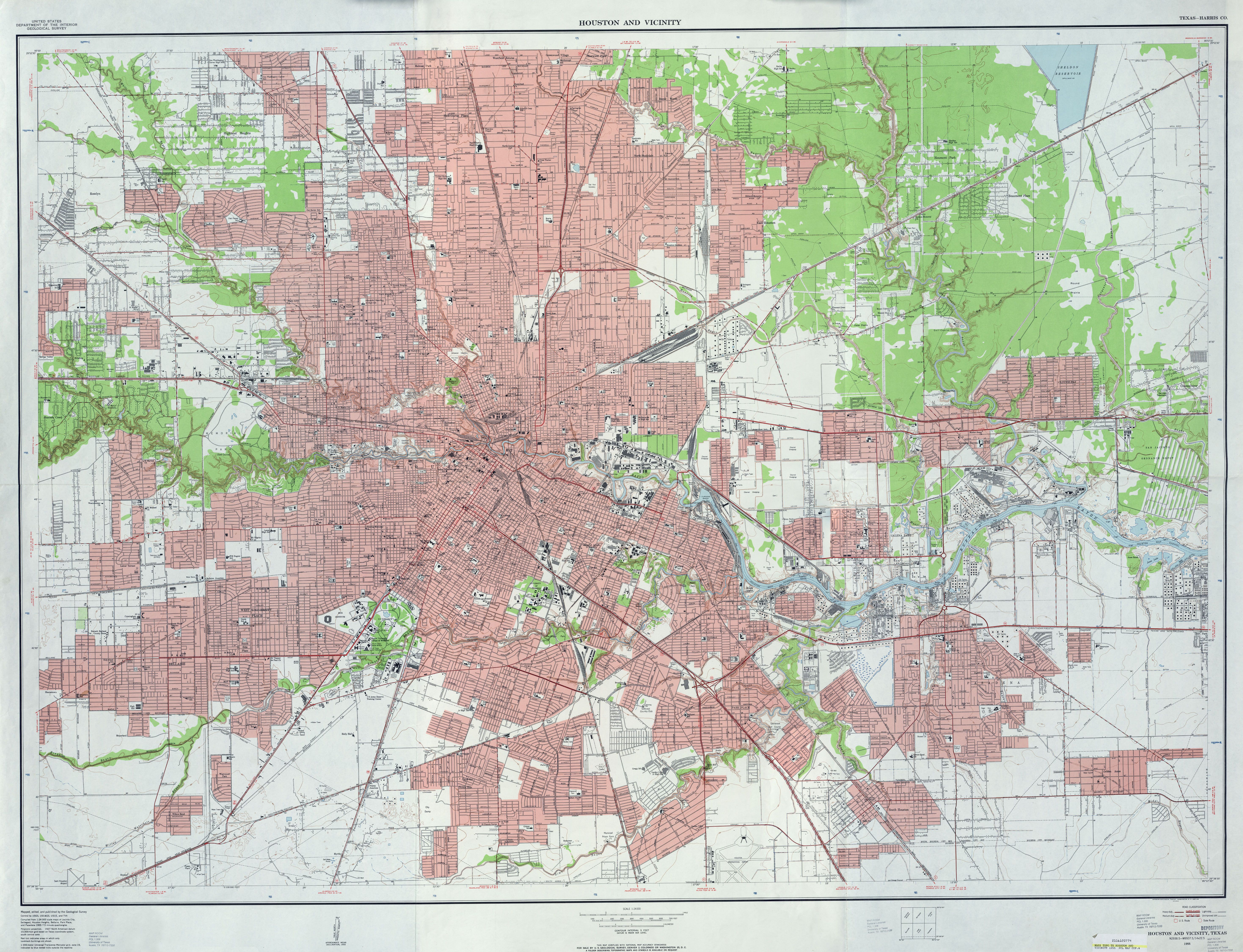
Want to find drive-in locations? Want to see Houston as it was in 1955, and in other years? Want to see how Houston roads evolved from haphazard, segmented lanes into superhighways?
Well, do I have a site for you!
I have known about the UT Perry-Casta�eda Library Map Collection for years now, but for some reason, I have overlooked one section of the map collection until a few days ago. It is a collection of various series of topography maps of most of Texas.
There was a series done around 1915-16, one done in 1947-48, one done in 1955, and others at later dates. When you open a map, look at the four corners as well as midway along each side to see the adjacent map name.
For instance, the Houston series from 1955 has, from west to east, north to south, Houston Heights, Settegast (downtown) and Jacinto City, and then Bellaire, Park Place and Pasadena. Maps adjacent to this main area can be found as well, and most of the Houston Metropolitan Area is covered for all series.
THIS MAP shows the six areas above on one map from the 1955 series. If you look in the general area of where you remember a drive-in being, you will probably find its location and layout. Playland Park is shown, as are other locations mentioned here often.
If you look at OST just east of South Main, there is an abandoned racetrack shown. Is that the old Arrowhead Park? I�m still in doubt as to where it was exactly.
The maps from the different years will correspond with each other for the most part. The top left of the 1916 Heights map should be the same exact location of the 1955 Heights map. As you scroll across and down, and going back and forth between maps, you can see how old roads were altered into new roads, how some were rerouted and how others were simply obliterated by time.
I love looking at and downloading these old maps. The proof of that is that I am still on dial-up, and it takes 15-20 minutes to download some of them. If you like old maps as much as I do, you will love this site, too!
I WILL LOOK AT THE PICS, TY............MAYBE THAT RACE TRACK IS THE OLD MEYER SPEEDWAY.........FOR DIRT TRACKERS
-
I remember the fortuneteller, but it didn�t bother me. What does bother me is that I can get up from the computer to get something in the other room, and when I get there, I forget what I went in there for.
Yet I can recall the most trivial of bits of information from when I was a kid. When you mentioned the fortuneteller, it came to me that there was a fortuneteller in a glass cage at the old Bill Williams Restaurant near Richmond. Why I would remember that I have no idea.
BILL WILLIAMS RESTAURANT WAS A GREAT PLACE TO EAT AND I ALSO REMEMBER THE FORTUNE TELLER................AS FOR AS THE REASON THAT YOU CANT REMEMBER FROM ONE ROOM TO THE NEXT.............HMMMM..........................IT'S CALLED GETTING OLDER AND I TO HAVE THAT SAME PROBLEM.
-
1
-
-
There's some info on Playland Park right here.
That area near Pearland has major suburban development now.
PLAYLAND PARK WAS NO WHERE NEAR PEARLAND...........IT WAS IN THE AREA JUST BEHIND WHERE THEY BUILT ASTROWORLD................PEARLAND IS SOUTH OF HOUSTON
-
1
-
-
When we went to Gulfgate Shopping Center back in the early 1960s, I remember going down some stairs to an underground bowling alley. I also remember my mother buying groceries in a Weingarten's store which was located at the end on the center next to Woodridge (I think that was the name of that side street). I can also remember going into a Newberry's store which was at the end of the center where a pedestrian bridge that traversed IH-610 from a movie theatre was.
Does anyone out there have any updated information on Gulfgate, such as if any of those old store from 40 years ago are still there or not?
Chet Cuccia
IT OPENED IN 1957, THE SAME YEAR MY SISTER WAS BORN--LIKE ONE POSTER SAID--IT WAS REDONE BY THE SAME PEOPLE THAT REFURBISH MEYERLAND
Are you saying that it's called Meyerland Plaza and not Gulfgate Mall as I heard?
Chet Cuccia
GULFGATE IS BORDERED BY WOODRIDGE, I-45 AND 610 AND STILL EXISTS THERE--------MEYERLAND IS ON 610 AND BISSONET I THINK, NEAR THE GALLERIA-----------TWO DIFFERENT SHOPPING MALLS
-
THERE WAS ALSO KITTIRICK ON CHAN 13....UTAH CARL FROM ALVIN....UNCLE BERT LYNN AND HIS KIDDIE SHOW....MILK DROP MO FOR FOREMOST MILK....
ALSO CURLY FOX AND TEXAS RUBY
-
Does anyone remember these old amusement places in Houston? what they were called? where there may be pictures of them?
The ski slope at the intersection of 610 West Loop and Southwest Freeway which later became...
The waterslide at the intersection of 610 West Loop and Southwest Freeway which finally became...
Lone Star Amphitheatre at the intersection of 610 West Loop and Southwest Freeway
OR HOW ABOUT...
Malibu go-cart raceway and arcade at the Southwest Freeway
Games-People-Play...I believe it was on Fondren....big 80's hangout with arcade, waterslides and go carts..
The little go cart place off westpark (Southwest Freeway ran in front of it)..the track was lined with red and white tires...

WILL ALL THESE PLACES THAT YOU MENTIONED YOU CANT BE VERY OLD......ON SOUTH MAIN, BETWEEN BRAESWOOD AND 610 THERE STILL IS OR WAS A PLACE CALLED KIDDIE LAND--IT HAD RIDES OF ALL KINDS, PEDAL CARS THAT YOU PROPELLED WITH YOUR HANDS, PONIES TO RIDE, ETC.............WAY BEFORE ASTRO WORLD, THERE WAS PLAYLAND PARK--IN IT'S HEYDAY IT WAS THE ONLY PLAY TO GO--IT WAS LOCATED JUST WEST OF WHERE ASTRO WORLD WAS--RIGHT BEHIND PLAYLAND PARK THERE WAS A RACE TRACK FOR DIRT TRACKERS CALLED MEYER SPEEDWAY, OH THOSE GOOD OLD CARS COULD RUN--THEN CAME COLT 45'S STADIUM (AN OUTSIDE STADIUM) FOR BASEBALL, SOMEWHERE AROUND 61/62--THEN THEY BUILD ASTROWORLD, A PRETTY DECENT PART OF TOWN THEN--THE BASEBALL GAMES WERE ABOUT $3 AND I THINK ASTROWORLD AROUND $5, YOU COULD DO TICKETS BY YOUR WEIGHT, COKE CANS,ETC--AN ALL OF THE OLD DRIVE IN THEATERS HAD PLAYGROUNDS RIGHT UNDER THE SCREENS FOR THE KIDS SO THE PARENTS COULD WATCH THE MOVIES--$1 DOLLAR A CAR LOAD OR YOU COULD SNEAK PEOPLE IN BY PUTTING THEM IN THE TRUNK OF YOUR CARS OR DRIVING THROUGH THE EXIT--THE OWNERS FIXED THAT PROBLEM WITH THE SPIKES, WHEN YOU WENT OVER THEM BACKWARDS KAPOW WENT YOUR TIRES--THEY HAD THE OLD BUSCH STADIUM ON CULLEN (MLK) AT I-45, TICKETS WERE CHEAP--HOT WELLS WAS A RPIVATELY RUN CLUB, HORSEBACK RIDING, SWIMMING AND THE SUCH--WE EITHER WENT SWIMMING AT CRYSTAL POOL ON SOUTH MAIN...IT HAD 3 DIVING BOARDS, A WATER SLIDE, A BUBBLE IN THE DEEP END WHERE YOU COULD GO ABOUT 12FT DOWN AND BREATH AIR, HOCKEY, TRAMPOLINES AND THE SUCH--IF ME AND GUYS WERE OUT FOR FUN WE USUALLY TRIED ALL THE WATER HAZARDS AT GOLFCREST COUNTRY CLUB...WE GOT TONS OF GOLFBALLS LIKE THAT--OR WE WOULD HIT ALL THE POOLS AT THE MOTELS FROM PARKPLACE TO COLLEGE AVE. AND PRETEND WE WERE VISITING, THAT IS UNTIL THEY CAUGHT ON--AND THERE WAS ALWAYS PUTT PUTT GOLF (MINATURE) --OR CRUISE THROUGH PRINCE DRIVE INS---IN OUR DAY WE COULD ALWAYS FIND SOMETHING TO DO
-
thanks for posting the pictures, idid.....it's the 1st time I've seen my old Montrose School in 25 years. I'm going to have to hunt down my class pictures from the 60's that were taken inside the classrooms and post them.
SOME REALLY GREAT PICTURES BUT SOME OF THESE SCHOOLS STILL EXIST AND ARE STILL BEING USED.
-
OLD SAM HOUSTON (CLAY ST DOWNTOWN) WAS MOVED TO IT'S CURRENT LOCATION ON BAUMAN---SAN JACINTO HIGH SCHOOL DOWNTOWN IS NOW THE MAIN CAMPUS FOR H.C.C.---CARVER HIGH SCHOOL BUT IM NOT SURE, THERE MAY HAVE BEEN TWO, ONE IN ALDINE AND ONE IN HOUSTON--WESTCHESTER AND SPRING BRANCH IN SBISD---FIDELITY MANOR HIGH SCHOOL, GALENA PARK ISD.
-
But it still exists...as HCC Central.
THE LAST CLASS TO GRADUATE FROM SAN JACINTO WAS 1969. IT SAT VACANT FOR SEVERAL YEARS UNTIL H.C.C. CAME ALONG. IT'S NOW THE MAIN CAMPUS


Near East End Mansions
in Historic Houston
Posted
I DONT KNOW ABOUT 2 OR 3 BUT 1 WAS A CATHOLIC CHURCH. MOST OF THE PROPERTY RAN FROM LAWNDALE TO ALMOST THE BAYOU..........IT HAD A BRICK WALL RUNNING THE ENTIRE LENGTH FACING WAYSIDE. ON THE OTHER SIDE, THE FIRST STREET PAST WAYSIDE WHEN YOU ARE GOING WEST ON LAWNDALE.......TURN LEFT OR SOUTH...........THEN WILL THE IRON FENCE YOU COULD SEE THE CLEARED LAND AND CHURCH, ETC.......THEY TORE IT DOWN FOR MONEY AND PROGRESS