

ernie5823
-
Posts
77 -
Joined
-
Last visited
Content Type
Profiles
Forums
Events
Posts posted by ernie5823
-
-
Evidently you were screaming so loud that you were not able to read what I posted - nothing about free markets, hate rhetoric, corporate America, etc. BTW, without "the free market" we would be living like folks in Russia, China, Cuba, or other third world dumps. You really need to grow up.
-
Nobody seems to want to remember what happened when Bush Sr. did a talk to schools. The Demonrats went ballistic, even having congressional hearings about it. They controlled Congress at the time, and ordered the General Accounting Office to probe the production of the speech and later summoned top Bush administration officials to Capitol Hill for a hearing. The Bush speech at Alice Deal Junior High School cost $26,750 -- an expenditure paid by the Department of Education -- and drew fire from Rep. William Ford, then chairman of the House Education and Labor Committee, who ordered the probe. "As the chairman of the committee charged with the authorization and implementation of education programs, I am very much interested in the justification, rationale for giving the White House scarce education funds to produce a media event."
-
 2
2
-
-
Hi all,
Can anyone give insight on Easthaven/East Haven? It is located directly east of Hobby airport and roughly bordered by Monroe to the west, Scranton to the north (though Airport is the largest street to the north), I-45 and Clearwood to the east, and Meldrum to the south (Almeda-Genoa is the larger street to the south).
I don't know how much traffic (aircraft) is in & out of Hobby now, but I don't think I'd want to live next door to an airport. I grew up 1 or 2 miles from there, when Hobby was THE airport, and it was very noisy.
-
Here is a list of the Kiddie Amusement Parks I grew up with:
Peppermint Park :*1st (Original) location - Reveille & Arnim (Gulfgate Shopping City) - 1960's (bldg. gone)
2nd location - Hwy 59 South (Southwest Frwy @ Beltway) - mechanics shop now?
3rd location - 610 North Loop (@ where it meets Hwy 290) - now a plant store
*It had a carousel, train, small roller coaster, helicopters,hand-petal cars,...don't remember live ponies.
The "original" location was in Pasadena, but I can't remember exactly where. I went to work at the park in 1960, shortly after they moved to the Reveille & Arnim location. Many of the guys who I knew had worked at the Pasadena location. Everybody made a whopping 65 cents an hour.
-
1
-
-
http://sloanegallery.com/newpage61.htm
There is a picture in this collection of the interurban railway, and the stop at Meadowbrook. Notice that it is of Spanish style. The land in the background sure was flat & empty.
Made lots of trips to Galveston with parents, from Meadowbrook, both before & after Gulf Freeway opened. Old Galveston Highway - US 75, I believe - went through lots of towns but the whole freeway route was pretty "flat & empty", as I recall it in the early to mid 1950s.
-
I-45 between Houston & Galveston was named "The Gulf Freeway" several years before the Interstate Highway System existed. Maybe that's why people, especially "old timers" continue to call it that.
-
As I understood the rumors, GM may be considering importing Chinese manufactured cars to the USA. UAW is obviously not a happy camper. Here's an article about rumors.
-
'Gary K' asked:
Regarding the arches, am I understanding things correctly:
1) The Gulf Freeway did not yet exist. Correct. Not until about 1952
2) The 3 routes from Downtown area to Southeast Houston (and Galveston) were: (Old) Galveston Highway, The "train"(?) whos tracks went to Galveston, and Winkler Dr. There was also interurban train (electric) between Houston & Galveston until mid/late 1930s & was operational in 1926 when arches were built. Don't know if regular train service (tracks along OGR) was available.
3) Perhaps the developer of Meadowbrook built the arches on Howard to attract attention (to the new subdivision) of the passers-by traveling the 3 routes listed above? Seems like would have been on the other side of Winkler - entrance to neighborhood, rather than entrance to nowhere. I'm not sure exactly where OGR arch was.
Ernie
-
Now that I look at the picture again, they do look like walkways w/ auto road in the middle, promotional ad from 1926. So approx. 20 yrs. later, who knows what was going on. There was a similar one described for Woodland Heights, with the same type of entrance, in an old book I read at the library. Would have been neat to see those gates, especially at night. No sign of the ballroom structure at the golf course, in 1946/47, I notice. Those apts. near Alaska were more like garage apts., parking underneath, very sixties, spiral stairs were outside, not a huge lot.
It just seems strange that there's nothing to either side of the arches & nothing to the west, with Howard dead-ending there. When the arches were built, I guess the interurban was still operational, so maybe there was a stop, or planned stop, at the arches. I don't remember anything about a "ballroom" at the golf course, just normal things you'd see at a golf course (I caddied there a while, before going to work at Peppermint Park) - maybe ballroom burned down sometime during the depression.
Ernie
-
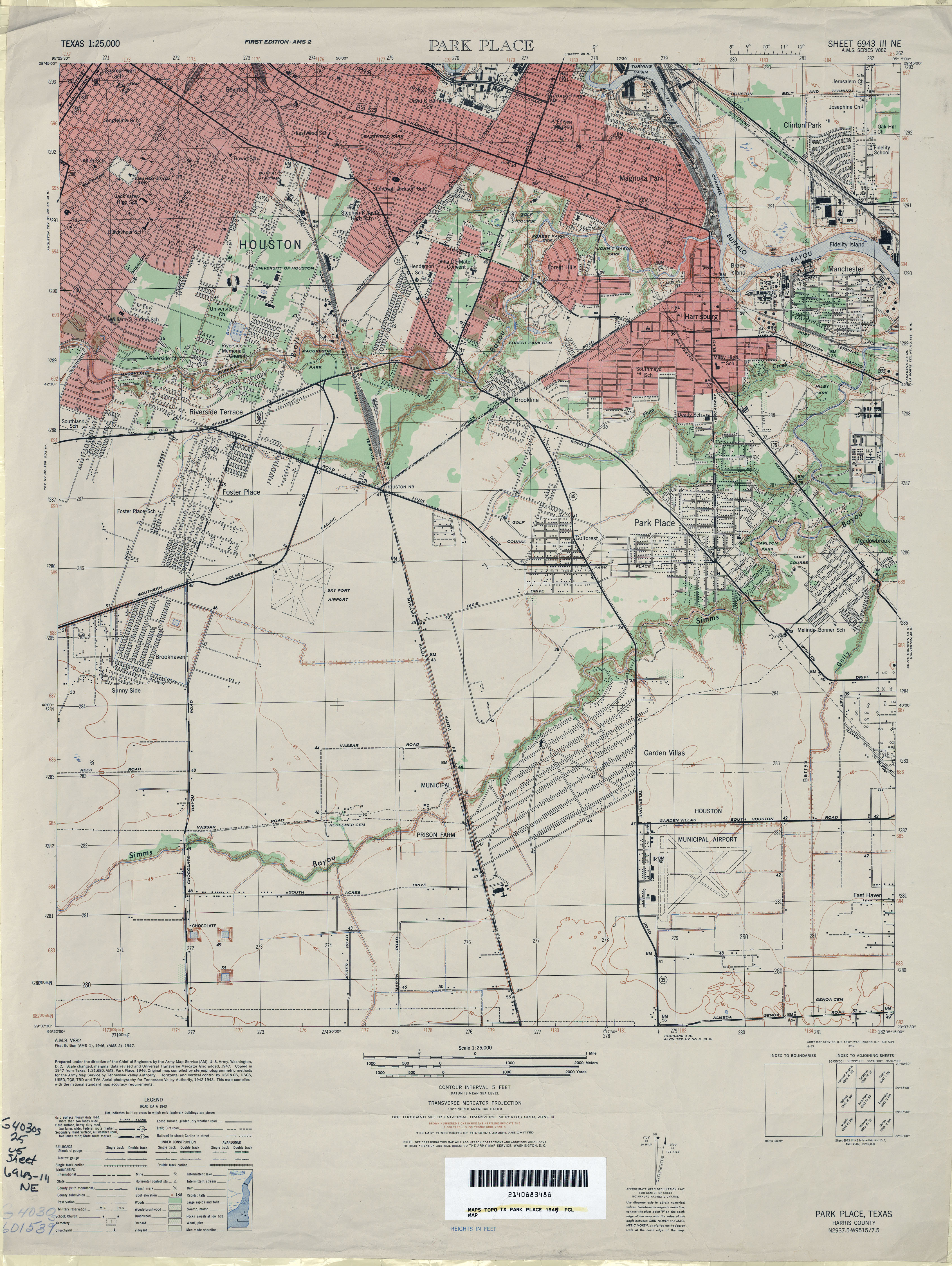
http://www.lib.utexas.edu/maps/topo/texas/..._place-1947.jpg
this 1947 map (from the houstorian map link) shows (in the right bottom corner) which streets & homes were the first ones in the 'hood. Guess the arches on the west side of Howard would have been located where that two lane entrance is seen on the map.
It's by the "Melinda Bonner" school name.
Neat map! Looks like map was actually from '46, with the gridwork added in '47. This probably does a good job of showing what was there before the war - and Dogpatch evidently was, along with all houses in 8100 block of Barkley (where I lived) and Lenore.
Interesting that many of the streets are not even there, or are not shown - and are shown on some of other maps from about the same time. I remember when Arizona & some other cross streets were just crushed oyster shell paved, but I was just one year old in '46, so no memory from that far back.
Looks like Arches were on other side of Winkler with no roads going to or through them. Maybe they were originally designed to be entrance to another phase of Meadowbrook - which ended up being called Glenbrook Valley after the freeway was built.
Ernie
-
It's surprising that the row of apts (on stilts) near the north side of Howard are still there. These are the ones right behind the once was a barbecue place right on the RR tracks.
I don't really remember anything about those apartments on Alaska - maybe they weren't there yet when I left Houston in '63. I know the barbecue place, on OGR side of RR tracks, wasn't there until later. Seems like it was first a filling station - some off brand.
Ernie
-
It existed in the 50s and early 60s, but it's just not in my memory banks. A friend who DOES remember it clued me to a website that has a lot of history about it, and a lot of names and pictures. The website is exactly like the HAIF website.
Check it out. http://txsz.com/forums/index.php?showtopic=21028
I remember a go cart racetrack somewhere along Gulf Freeway (southbound), but I think it was further north. This "memory" is from late '50s, when I was in Jr. High at Deady. The track had a lot of hairpin turns & was pretty interesting to drive - in a "vehicle" where your backside was only about two inches from the ground.
Ernie
-
I worked at Peppermint Park after school & summers, 1959, '60 & '61. Would probably be against child labor & OSHA laws now since I was only 14 when I started. I remember that I was hired & started work with no social security card, but had to promise to get one. As I remember it, the park was only open Friday afternoon, Saturday & Sunday during school year (since all who worked there were students - mostly from Milby, but a couple from Austin & Mt. Carmel). During Summer, it was open 7 days a week. We made $.65 an hour, no overtime. Working the birthday parties (usually Saturday AM, before park opened at noon) was a real bonus. Our "party comp" was $3.00 plus whatever we might get as a tip. Once I got a $5.00 tip, but it was usually a buck - if anything at all. For that $3.00 we had to take the kids on all rides & help serve drinks, cake, etc.
The park was originally in Pasadena & moved to the triangle formed by Revilee & Gulf Freeway frontage road in 1958 or early 1959. The train went around the whole fenced perimeter of the property, most of it open space. It was right across Revilee from the Carousel Motel & the park parking lot, between frontage & Revilee, backed up to houses in that neighborhood.
-
I just looked those houses up on GoogleEarth...couldn't find a red brick fence...maybe was just in my imagination.
 ...some addresses are (approximately) 8354 Howard(covered in English Ivy, on corner), 8310 Howard, Red Brick traditional, black shutters, 8326 Howard, Blue? Brick (whoa), 2 story, Traditional. These were all on the south side of the drive. There are some nice one story tan brick ones on the north side. This layout reminds me of Park Place, with the blvd. & median.
Those are pretty neat, but check out 8334 Barkley - looks a lot larger. Also, house at 8466 Howard. I remember when that was one of nicer houses around. Was a large "L" shaped ranch. Howard was two lanes, just like other streets in area, when I lived there.
Ernie
-
There have been businesses on Howard Dr. as long as I can remember...mostly houses turned into them. From lounges to chiropractors to a Utotem to daycare facilities, to photographers to furniture showrooms. From late 1960's, on. Nothing new, IMO.
BTW, two residences that always stood out to me (on Howard) are the house across from Utotem, east of it (used to be covered in bushes, for the longest, very mysterious) north of Howard, and the SaltBox? rectangle one, same area, south side of Howard. The second one always seemed so different to me.
I just looked at those houses on GoogleEarth. First one not so interesting now, you can actually see it. And the second one is a business...go figure, address: 8446.
I can't say exactly when, but I seem to remember when the Utoem was built. Seems like 2 or 3 houses were removed or demolished to make way for it.
Another one, maybe two, "interesting" houses on Howard were next to or very near the Baptist Church, but I can't see them now - maybe replaced by parking lot or commercial building. One house, still there, on Barkley that always seemed "out of place" is the large two story brick in the 8300 block. Maybe it was built at very beginning, when expectations for the neighborhood were higher than 900 sq. ft. frame houses.
Ernie
-
nope..same howard.
Check out this article from the chronicle archives:
http://www.chron.com/CDA/archives/archive....id=1999_3132904
According to the 10 year old article:
"The business owners say all they want is a reprieve, more than the 15 days given them, to examine whether there remains a possibility of changing the deed restrictions. Or at least they want more time to move."
Evidently the businesses got a lot more than a 15 day reprieve! I wonder what the result was with the City Attorney
The Meadowbrook Civic Club didn't amount to much when I was a kid, evidently still doesn't amount to much or have any real authority - and definitely shouldn't be confused with a Homeowner's Association. According to the article, 75 business owners & homeowners were at the meeting. This wouldn't even represent a quorum (10%) at a Homeowner's Association meeting.
Ernie
-
Houston still doesn't have zoning but I think Howard is still "protected" from commercial with deed restrictions.
We must be talking about different Howard Drives. I just "drove" through the Meadowbrook portion (using Google street scene), from Winkler to OGR & back. It may not have been over 50% commercial, but it was close - lots of houses with front yards paved & house converted to some commercial use & several actual commercial buildings. I can remember when it was ALL residential, except for the Baptist Church at Arizona & Smith's Grocery at Winkler.
Also, I can't really imagine any effective Homeowner's Association in Meadowbrook. There sure wasn't any such thing 35 years ago when my mother sold her house on Barkley.
Ernie
-
The north side of Howard has always seemed to stay "nice" to me. The lots seem bigger. Why was the neighborhood, park & pool not named the same? Confusing...Glenbrook Park, Pool & Meadowcreek neighborhood. And Glenbrook being on the other side of the freeway.

Some of the lots on Howard were double, maybe triple width & a many of houses were "nicer" than other areas. These were probably early construction, late '20s or early '30s. Last time I was there, 8 or 9 years ago, looked like Howard was mostly commercial. Don't know if it was rezoned or if Houston still doesn't pay much attention to zoning.
I don't know when the pool was built, but closest one when I was a kid was Pasadena.
Ernie
-
Sure do wish that the maps had a date stamp on them, so we could tell exactly when each one was.
I can come a little closer to dating these. After 1947, when USAF split from the ARMY, Ellington was renamed as "Ellington AFB" rather than "Ellington Field", so the second map is before 1947 & first one is even before that. Note that the church between Howard & Barkley isn't there in first map. Also, first map is missing a bunch of houses that I remember on Barkley & Howard. I had a friend that lived in 4th house from Radcliffe, south side, on 8200 block of Barkley. That house looked like a late '20s/early '30s brick house, unlike most of frame houses, it is there on both maps. If you have these maps for 8100 & 8000 blocks, we could further isolate the time, because I know "my" house, on Barkley, was built between 1938 & 1941 (I could probably be more specific, but I'd have do dig in boxes in attic for papers).
Ernie
-
So it had something to do with housing for Ellington Field, possibly an overflow due to insufficient space at the airfield?
I always wondered about this, because Dogpatch is not exactly close to Ellington. Although the two were/are accessable via a drive on (Old) Galveston Hwy.
It would be so very interesting to get a look at Dogpatch back in its earliest days, and military days.
-Gary K
From the way other streets are filled in, looks like it was first a Federal Housing Project & later NCO housing for Ellington. Sure do wish that the maps had a date stamp on them, so we could tell exactly when each one was. As far back as I can remember, dogpatch was considered an undesirable area (as all of Meadowbrook probably is now), mostly rentals but with a few well kept homes. I had a friend whose parents bought a whole duplex, knocked some walls out & made a nice large (maybe 1600 sq ft) house out of it. The house I grew up in was about 850 sq ft, so 1800 seemed huge.
-
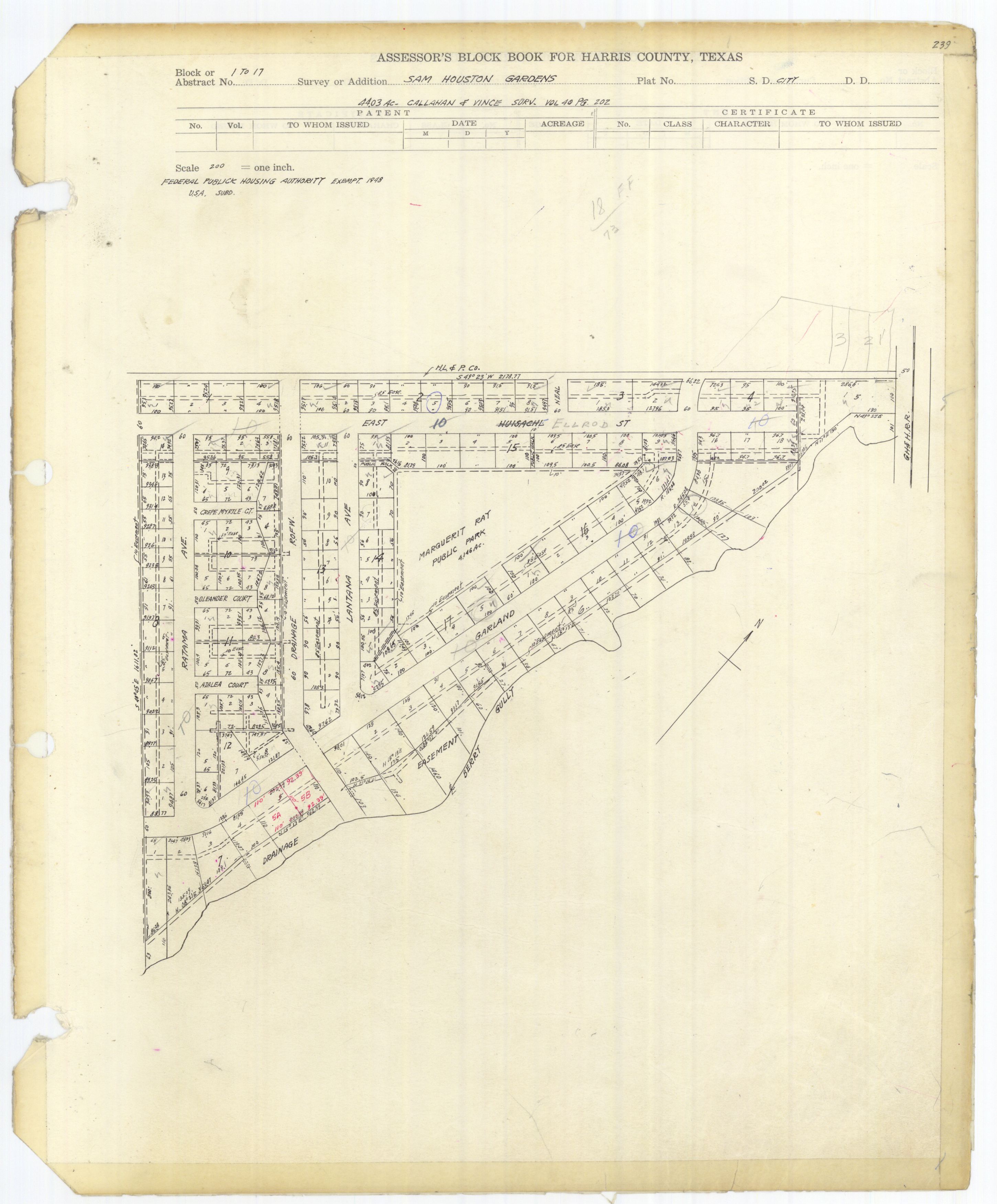
I found a plat map of "dogpatch" - see link below. Map indicates that there WAS some connection between the neighborhood & the "Federal Public Housing Authority", which operated between 1937 & 1949. Seems like many folks believe it was wartime military housing, so I might be wrong about post-war construction - wouldn't be first time & probably won't be the last.
http://books.tax.hctx.net/v075/AE1997_75-2_0094.jpg
Ernie
-
I wonder how the "Dogpatch" name for that area came to be?
Where was the community center located? In the middle of that park? And did you attend Bonner Elementary?
And, I'm curious how the developer of Sam Houston Gardens and Meadowbrook picked those street names: Howard, Garland, Elrod, Ratama, Mildred, Bendell, Bliss, etc. These mostly seem to be people's first or last names. If so, were these "real" people?
-Gary K
I don't remember, maybe never knew, how dogpatch was named or any of the street names either. As I remember it, the building was about in the middle of the park,
Yes, I went to Bonner - a "mid termer", started 1st grade in January '51 - then Deady & Milby.
Ernie
-
It's good to see more discussion about my old neighborhood.
Sam Houston Gardens was proper name for area bounded by Elrod, Garland & Ratama streets, but everyone called it dogpatch. When I was a kid, there was a large clubhouse/community center, where boy scouts met, at the park, in middle of neighborhood. I lived a couple blocks away but had lots of friends & classmates that lived in dogpatch. I'm pretty sure this area was built as Federal Public Housing, just after WW2, to accomodate returning, discharged GIs. Most all of the units were duplexes & the ones that were not were equivalent to half of a duplex. All of the units looked about the same when I was a kid - either white, gray or tan asbestos siding & casement windows - typical post war cheap construction in the area. Most were rental units but, later on some were sold & owners did some improvements.
If I'm not mistaken, Howard Dr. didn't actually "cross" Galveston Road until sometime in the '60s, but rather ended at OGR. I remember a stop sign & later a light there. Just across OGR were a couple beer joints & some other buildings. Later, Howard was extended over into Oak Meadows/Forest Oaks area.
Ernie
-
Welcome! I always liked Meadowbrook for it's diversity in house types, styles, & lot sizes. They were also a mix of 1 & 2 stories, with differing yrs. built, including a few small 1960's apts. The 'hood I grew up in was cookie-cutter, all very similar one-stories.
Houses on each "end" of the neighborhood (streets by golf course & one or two on southeast end) were upscale (brick houses built late '40s or early '50s, I think) compared to most & *way* upscale compared to "dogpatch" section, on Elrod, Bendell & a couple other streets. Most apartments that I'm aware of (along Winkler & one small unit on Barkley) were built in the '50s or *very* early '60s. Meadowbrook was a good place to grow up in the '50s & early '60s. My mother lived there until '75 & it wasn't too bad then, but the last 30+ years have not been too kind to it.
Ernie Hurst

 ...some addresses are (approximately) 8354 Howard(covered in English Ivy, on corner), 8310 Howard, Red Brick traditional, black shutters, 8326 Howard, Blue? Brick (whoa), 2 story, Traditional. These were all on the south side of the drive. There are some nice one story tan brick ones on the north side. This layout reminds me of Park Place, with the blvd. & median.
President Obama
in National Politics
Posted
I have no problem with what he actually said in the speech, or with what any past president might have said in their speech. As long as we're talking about working hard, staying in school, etc., that's OK, but is what parents ought to be doing. I would bet that a high percentage of kids that heard it, have forgotten what they heard by now. I did have a problem with the lesson plan that was sent out (& then ammended) & with all of the republican complaints about the address - as well as the democrat complaints back in '91.
Too bad some people think they have some right to not be offended & start screaming about hate rhetoric every time they hear something they don't agree with. Let's turn this around - If I was really a rabid right winger, do you think I just might be offended by quite a few of the posts here. Sure am glad that I don't really have to take any of this crap too seriously.