

John Rich
-
Posts
105 -
Joined
-
Last visited
-
Days Won
1
Content Type
Profiles
Forums
Events
Posts posted by John Rich
-
-
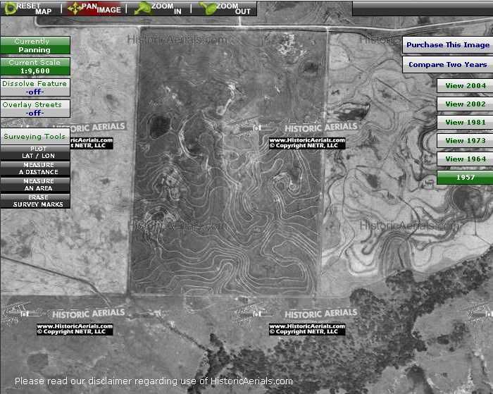
Looking at 1957, there are a bunch of strange squiggly lines east of Eldridge. Any idea what this was?
You mean like these?:
http://i18.photobucket.com/albums/b108/Joh...uigglyLines.jpg
Those are probably terraced rice fields, which require precise water levels for proper growth. The squiggly lines are where the farmer built up dikes, following the terrain contours of the land, to hold water. You can still see this kind of landscaping in today's rice fields.
-
John, do you know of any explicit authorization to enter these areas? I know they're not really patrolled, and even if they wanted to its not drivable through the forest, and the fact that the signs say "No Motorized Vehicles" and "No Firearms" are encouraging, but is there something more significant?
Yes, right here, at the Corps of Engineers web site: http://www.swg.usace.army.mil/Addicks/
Secondly, what do you think the chances are of finding some more home sites in that massive area? It feels like exploring old jungles for Mayan ruins or something, very exciting.That's a good description for the feel of finding those lost home sites. From the old aerial photos, I'm not sure there are any more in that particular patch. I'm also considering going searching for some in the Barker reservoir, which is the one in the southwest quadrant of I-10 and Hwy 6. Those 1957 aerial photos are great for locating old home sites. And if you can get your hands on some old government topo maps, those will show things as they used to exist also. I'd also like to find some photos of the old town of Addicks, but those seem hard to come by. So much research to do, so little time to do it...
Also, I followed Lamb Road for a while, through where the new growth trees are, but shortly after that part it opens up into a clearing of sorts. I wasn't able to see where the road continued on.Yes, it seems to dead end there where it starts to get clear, just beyond where that concrete cattle-guard bridge lies. You are also very close to Langham Creek at that point. If you continue west, you get to a pretty area along the creek, with turtles sunning themselves on logs. It's a great lunch spot.
There is one snippet of an old topo map from the previous "Addicks Crop Circles" thread, which seems to show Lamb Road extending across Langham Creek and going over to Hwy 6. But I can find no trace of any old bridge along there. If there was one, it must have been wood, and has since washed away.
There are plenty of logs which have fallen across the creek, that you can use to tightrope walk across to the other side, if you dare. There's one particular big log that is low over the water, very large, perfectly horizontal, and somewhat flat on top, and is the best crossing point. I even sawed off a limb that was an obstacle about a third of the way across. But that log is about a half-mile south of where Lamb Rd. ends. That's the log featured in a few of the slideshow photos.
- John
-
For those of you who are contemplating hiking to these old homestead sites, here's some info for you.
Reference the slideshow mentioned earlier in message #1 to see the landmarks to which I'll refer.
Site #1: This is the site a few hundred yards northwest of the "crop circle" stock ponds. Since it's easy to find without technical gizmos, I didn't bother capturing GPS coordinates. Directions: hike Lamb Road west about one mile, until you see the concrete cattle-guard bridge - it's a "can't miss it" landmark. Turn right, cross the bridge, and head north on the trace of the old road bed, now overgrown with trees. It's slightly raised, with drainage depressions along both sides, but is faint. Follow that north about a half mile until you see the big gnarly tree - it's very distinctive compared to the other trees in the area. The home site is behind that tree.
The other two would be very difficult to find just by dead reckoning, as they are well hidden inside thick woods, with no landmarks to follow. So I'll give the GPS coordinates for them which I captured.
Site #2: This is the first site to the south of Lamb Rd. You'll have to cross a barbed wire fence or two. You may need to belly-crawl under them, squirming on your back, holding up the wire with your walking stick.
UTM coordinates: 0246314E, 3299626N, datum NAD83.
Site #3: This is the site furthest south. It's easiest to get to when approached from the south, from the power line cut. And if you start from the south to get to this site, then Site #2 is only another quarter-mile due north from there. So this is a good way to take-in both of these sites.
UTM coordinates: 0246337E, 3299210N, datum NAD83.
Be sure to also look around the general area for a 100-yard diameter or so from the GPS location, because there are also outlying building ruins away from the central location.
Please respect these sites and don't vandalize them. In fact, take a plastic bag with you and carry some trash back out.
I thought it might be fun to leave a geocache in an old ammo can at these sites, for people to search out and discover, and to encourage people to enjoy and appreciate the area. But I'm not sure that would last, because the box would float away with each flood. And if you tied it down, it might end up underwater and get water intrusion into the box, spoiling the contents. Site #1, the furthest north, might be high and dry all the time. But the other two are far enough south towards the dam that I think it would go under water when the reservoir fills up, which seems to happen once or twice per year.
- John
-
Was this the same house with the 1925 markings? The area wasn't commissioned as a reservoir until 1938 if Google steered me right, so perhaps that's why the house is lower.
Yes, the 1925 house. So it was indeed there before the dam. The residents were probably kicked out under eminent domain law when the Feds took over the land for the reservoir.
The swallow may fly south with the sun or the house martin or the plover may seek warmer climes in winter, yet these are not strangers to our land?Huh? Another thought, not involving swallows or poetry: There is a fishing pond in the area, and perhaps a fisherman brought some big clams with him to use as catfish bait. But this one was intact, not broken open. Could it have escaped from the bait bucket and snuck away?
The giant apple snails are actually interesting creatures. They live underwater to hide from predators like birds and raccoons, and breathe through a tube like a snorkle. When a water hole is drying up, they burrow down in the mud and go into a hibernation mode, to awaken the next time rainfall fills their pond. To lay their eggs they crawl up a tree trunk and deposit them in pink clusters above the water line. There are thousands of these empty shells out there. I have yet to see a live one!
-
I went out there last week to the old road south of Patterson... It was pretty neat back there. I may return for a low impact camping trip. I carry my bivy (a style of one-man tent) and my sleeping bag on my bike and can set up and break down pretty quickly.
There are some excellent camp sites along Langham Creek, with higher ground, clear of debris and overgrowth. I'm surprised you're able to bicycle through there, as thick as the woods are.
Isn't it kind of far inland for a clam that size?Indeed it is. That's just one of the mysteries that I've found in the woods. What's that big clam doing out there? I've also found coconuts on the ground back in there, and we're a long way from the south pacific. You can always just say that they washed into there during a flood. But from where? There is no ocean or coconut trees on higher ground to the north.
I think the concrete platform was for some kind of machinery. Maybe a generator or something that would need to stay dry if it flooded.But the house itself wasn't built up that high, and surely they would protect it first. Unless that platform was built much later, taking into account the new dam and flood levels. Or maybe it just needed elevation for a water tank to provide the kind of water pressure from gravity to serve the home. Curious stuff.
"The box" looks like an old barbecue pit to me. You see similar styles even in modern campgrounds, and the blackened interior seals it for me.Could be. It's similar to the types that have two chambers, where wood is burned in one chamber to produce heat, which is vented to the adjacent chamber where the meat is cooked. If so, someone sure went to a lot of trouble to make a fancy BBQ pit.
-
Good day, HAIFers!
I've been doing some hiking in the Addicks Reservoir in west Houston, which is managed by the Army Corps of Engineers.
It's called "Addicks" because that's the name of a former town there, settled by German immigrants, whose homes were scattered around the area. After repeated flooding showed the area to be unsuitable, they moved on elsewhere.
This is the patch of woods bordered by the Katy Freeway on the south, Highway 6 on the west, Patterson Road on the north, and Eldridge Parkway on the east. It's about 9 square miles of undeveloped land, used as a flood plain.
Many of you may drive right by this primitive tract every day, and never think about what might be contained deep inside, or the history of that area.
Here is a slideshow presentation with photos from my hikes, containing 77 images:
http://picasaweb.google.com/JohnRich3rd/LanghamCreek
Just click on that web link, and then click "slideshow" to view the photos.
You will want to immediately click the plus-sign at the bottom of the screen to increase the number of seconds of viewing time per photo, or they'll whiz right past you before you're done looking. Then use the arrow keys to scroll through the photos, as you're ready.
This presentation will cover the two "crop circles" located there, which were talked about extensively in another thread, as well as the ruins of three old homesteads that were formerly located there. At least one of those dates from the 1920's.
If you have any comments to make in identifying some of the odd home site structures found there, please chime in - I'm curious to figure out what those are. This would include the tall spindly-legged platform, and "the box".
After viewing this, the next time you drive past that piece of woods, you'll glance over and think about what you've seen in this slideshow, and what life must have been like for those families back then. But the history doesn't stop there with the early Anglo settlers. This area was also occupied by Indians going back 2,000 years, and archaeologists have unearthed their burials and artifacts in this area.
Enjoy!
- John Rich
-
Thanks for your contribution John!
You're most welcome.
I've done some more hiking in that patch of woods, and have located two more sites where there were ranch homes, from as far back as the 1920's. I'll be putting together some photos for everyone here to see. I may start a different thread on them, in the "history" section. It'll take me a few days to get the photos organized and ready for presentation.
- John
-
Re: William Bracken, age 16
Quote:
"Police are still investigating the case, but say the boy may have jumped off a five story parking garage. However, they are not calling it a suicide.At this point they are not ruling out anything, and neither is the medical examiner's office."The cause and manner of death is pending further investigation. At this time, we really don't have a clear picture of what happened at the time of death..."Source: Texas Cable News
Maybe a bicycle stunt gone bad?
-
I have. By reading this thread, I have been able to determine that you're a new guy who wants to give his political opinion.
Your original descritpion of me was "FNG", or "f--king new guy". It's nice of you to now sweeten that up without the profanity. Perhaps that's a recognition that you now realize that wasn't very proper. Maybe if you had done that in the first place, it wouldn't have raised my hackles in response.
But now that we've eliminated the profanity, there's still the phrase "new guy". What does that mean, exactly? Why do you bother to point that out? Is there something less valuable about the opinions of new guys? If you were King of this forum, would there be some mandatory number of postings required before you would give credence to someone's points?
Once again, newness means nothing. Judge a man by what he says, not how long he's been around.
Because if you want to go that route, we can talk about how little worldly political experience the new President of the United States has. So which way do you want to go?
-
Oh, goody. One of my favorite things--an FNG wasting no time in Way Off Topix.
Most hated people:
DubyaConservativesRepublicansChristiansThere. Is that better for you?
Yes, that's a much more constructive dialog. <sarcasm>
But wait, let's try some logic. Why are people hated? Because they're to blame for things that have gone wrong. So blame and hate go together. That's why some people hate President Bush, because he is perceived as being to blame for everything that has gone wrong.
Thus, we can now jump forward to the new Obama administration. Now that there aren't any republicans or conservatives in leadership positions any more upon whom blame can be heaped, and to despise for what has gone wrong, upon whom will the liberals and democrats now heap blame and hate when their own policies fail?
Maybe you should try judging posts by their facts and logic, rather than by the number of overall posts they've made.
Judge a man's messages by his quality, not by his quantity.
-
Don't forget Dubya...
After today, the liberals and democrats won't be able to blame Dubya anymore.
Who will they blame when the financial crises doesn't get any better?
Who will they blame when Israelis and Palestinians continue to fight?
Who will they blame when they can't get the troops home from Iraq and Afghanistan on schedule?
Who will they blame when the Social Security system continues to go bankrupt?
Who will they blame when Iran continues to threaten Israel and the United States?
Who will they blame when the government doesn't provide free health care to all citizens?
Who will they blame when global warming continues to increase?
Who will they blame when gasoline prices go up?
THEY own the House of Representatives.
THEY own the Senate.
THEY own the Presidency.
THEY own the Cabinet.
Who will they blame?
-
We're all Americans NOW!
You mean we weren't before?
-
they require you to shoot brass cased ammo as opposed to steel has nothing to do with safety. It as has to do with the fact that they want to sell the brass.
I'm not sure I agree with that.
It's true that brass has resale value. But if you reload and want to keep your own brass, I've never seen a range that won't let you collect and remove your own spent cases. However, they don't want you picking up everyone else's that gets left behind. That seems fair enough to me. Reselling that bulk brass helps keep expenses down, so you get to shoot cheaper.
Steel case ammo (and aluminum) typically will malfunction more often than brass case ammo. And failures to feed or extract can lead to dangerous gun handling as people try to clear their jams. So there could actually be a safety aspect to this rule too.
Re: GHGC. Man I read your post and got all excited until I went to the site and noticed it's shotgun only. Is that for real? What's the point of that?It looks like it's too close to developed areas to safely allow rifle shooting - accidental discharges into the air can go a mile or more. Shotgun pellets, on the other hand, don't go very far at all.
Shooting Range near the Heights?What kind of shooting do you do? Pistol? Rifle? Shotgun? IDPA? Long range? .22 rimfire?
How close do you consider "near"?
You might consider Bayou Rifle Club. It's a private club that requires membership. But once you join, you get the combination to the gate, and you just let yourself in and shoot when you want. No crowds. No yahoos. They have two ranges, one south on Hwy 288 outside Highway 6, which has handgun ranges and rifle ranges out to 1,000 yards. Another range near Eldridge and I-10 is for handguns and .22 rimfire only. They have active monthly shooting match programs.
Their website is here: Bayou Rifle Club
They've just redesigned the web site, and the range information page is broken right now.
The type of shooting I enjoy most is long range rifle, shooting everywhere from 200 yards out to 1,000 yards.
-
While I'm at it, here's a few photos from the Hillendahl "Blue Light" cemetery:
This cemetery can be visited with just a very short walk of only about a quarter-mile across an open field.
1) Road map.
2) Aerial view.
3) Surrounding fence.
4) Gate, unlocked at this time.
5) Mossy old headstones.
6) Headstone footings.
7) Sample modern marker replacing former headstone.
The headstones were apparently vandalized and stolen in the past, and the area is subject to flooding. Some or all of the graves were moved to the new Bear Creek cemetery at Highway 6 and Patterson Road, near the Farm & Ranch club.
At the time of my visit, the area inside the fence was badly overgrown with foliage, in stark contrast to the well-manicured remainder of Bear Creek Park. I looked up the phone number of the park manager and spoke with him about the deplorable condition of the cemetery. A week later, he had a crew out there to clean it up. Thank you very much.
As I understand it, this is the situation with responsibility for the cemetery. Bear Creek Park is on flood reservoir land leased from the Federal Government, so the County is responsible for maintaining that leased land. However, the cemetery itself is still Federal land, not part of the County lease. So technically, the County is not responsible for maintaining it - the Army Corps of Engineers is. But the County Park manager did it anyway, just to make things right.
Scratch the photo attachments - I'm out of space for pictures here.
Go to this web site to view my brief photo slideshow: Hillendahl Cemetery
Just click on that web link, and then click "slideshow" to view the photos.
You will want to immediately click the plus-sign at the bottom of the screen to increase the number of seconds of viewing time per photo, or they'll whiz right past you before you're done looking. Then use the arrow keys to scroll through the photos, as you're ready.
- John Rich
-
There seem to be dual threads going on simultaneously.
Rather than duplicate everything in both places, I'll just reference the other message.
A new report on this topic, with additional photos, can be seen here:
-
Thanks for posting, and welcome to HAIF.
I'm not sure if you have seen the other thread about the Addicks markings here - there are some recent discussions and a few pictures.
Thanks for that reference. No I hadn't run across that one yet.
And WOW! I love that web site with the historical aerial photos. That's an amazing resource!
- John
-
Hello. I'm a newcomer to the forum and this particular discussion. I became interested in this Addicks Reservoir area independently, and ran across this forum in my research. I've put my boots on the ground and hiked the area, so I may have something worthwhile to contribute with my comments. Here is my two-cents worth.
The "crop circles" are definitely man-made, in my opinion. The dirt has been scooped out and piled around the edges to create these bowl-shaped circles. In one, two intersecting high lines run through the middle, upon which small trees have now grown, creating the "cross" appearance on the aerial photos. On the other, the dirt was also piled into an island in the center, with one large tree growing on it, creating what appears to be a "mound". I think these are nothing more than stock ponds, that some rancher created with a bulldozer to store water for his cattle.
In support of that theory, I offer this: If you follow that dirt road west, you come to a small one-lane concrete bridge over the ditch alongside the road. That bridge is in the form of a cattle-guard, with parallel beams spaced apart with gaps between them. These kinds of bridges are common on ranches, because cows won't walk across them, because they fear their hooves will fall through the gaps. Thus, you don't need a gate to keep the cattle from escaping.
If you follow the slightly raised overgrown road trail running north from that bridge, you come to a small concrete home foundation, with some Acme bricks scattered around. There is also an old brick-lined well, partially covered with railroad ties. And there is a concrete water trough, used to support livestock. Also some fencing in the shape of a cattle chute, used to get cattle into a single line to be loaded onto a trailer. There is also another small stock pond just north of this home site.
The story someone posted of the LH7 ranch operation also buttresses this theory.
As for the pond-and-cross, perhaps the rancher had segmented pastures so that he could move his cattle from one to the other, as is common, to allow grass to grow in one place, while the cattle are eating it all up in another. And the fence line for those segments might have criss-crossed right through the middle of that pond, on purpose. So each of the pasture quadrants had access to water from the same source, no matter which quadrant they happened to be in. That way one pond served four pastures, instead of having to build four different stock ponds, with one in each pasture. That's a wild idea I had on this.
So, with all that, I think that this was just a cattle ranch area, and those "crop circles" are nothing more than a creation by a bored cowboy on a bulldozer, making waterholes for his livestock. He's probably sitting back sipping a beer right now, laughing his ass off at all this wild speculation he created, decades later.
Those are my general impressions.
Now to respond to some specific questions and speculation.
The area isn't maintained by man. The raised roadbed is overgrown with trees, and obviously hasn't been driven on for 20 years or more. The reason the circles look maintained is simply because they are swampy areas, mostly underwater, and it's like a small pond. There are lily pads and reeds growing in them, but that's it. They may dry out now and then, but they're underwater often enough to keep trees from taking root and surviving. The surrounding embankment and higher land has trees.
These are not Indian mounds. However, archeological surveys have found Indian middens (trash piles) in the general area, including buried skeletons, up to 2,000 years old. So ancient people lived and camped here, but they did not create these particular land features. The first archeological survey was in the 1940's, and there have been several since, including some formal digs. These reports are at the Houston Museum of Natural Science, and copies are at the Houston Archaeological Society.
If you're worried about that "mystery road" (Lamb Road) gate, you can park south of that where there is a break in the guardrail underneath the powerline crossing, which is just north of where Eldridge goes over top of the dam. It's an access point for pipeline and powerline maintenance trucks. People go through there to fish at the pond. Then you can hike north on the pipeline cut to get up to Lamb Road, then follow that west. Total hiking distance, one way, is only 1.5 miles from there.
As far as trespassing goes, I believe this is all federal land, part of the Army Corps reservoir, and is therefore open for hiking to the public. Their web site even says so.
If you don't have GPS, you can still find the ponds. As you hike west on Lamb Road, watch the ditch on the right closely, and you'll find an old rotten wooden bridge over the ditch. That's where you want to turn north to go to the ponds. Watch your step, as you're likely to fall through. It's easier to go around it - the ditch is very shallow. The ponds are only a couple of hundred yards north, and if you look up at the treetops ahead of you, you'll notice a gap in the forest canopy when you get close - that's where the opening from the pond will be. I found both just by dead reckoning, and didn't resort to my GPS. Once you've found one, you can get to the other using a compass bearing. If you're at the circle-and-cross pond, just hike north-west to get to the second pond with the island in the center. Then go back south to Lamb Road, and follow it west until you see the concrete bridge, and follow that roadbed north to the home site. Return to Lamb Road, and hike west again to see Langham Creek.
Where Lamb Road ends at Langham creek, was used as a dumping site for trash. There is an old freezer, a washtub, a refrigerator, and plenty of old bottles and other trash. It all seems to be 1950's and 60's era stuff. The reservoir and dam was created in the 1940's. The road to the home foundation site is also littered with bottles and cans.
The pictures of the circles already posted in the thread are just like the ones I took this week.
You won't make it very far on a bicycle, or an ATV. The trees are dense. There is no way that any kind of tractor gets back there to mow the grass. It's gone wild. On foot is the only way to go.
As for the Blue Light cemetery, it does indeed still exist. If you go to Pavilian 8 in Bear Creek Park, and look to the south, you'll see an open field through the tree line. That's where the German settlement of Addicks used to be. On the south side of that field is a fenced area, and inside is the Blue Light cemetery. Very few original headstones remain. There are a few footer stones. And modern markers replacing the stolen/vandalized original stones, indicating who was buried there, and their birth and death dates.
As for the flooding in the original town of Addicks, I think that was happening even before the dam was built. After several flood cycles, the townspeople decided it was a bad location and they split up and moved on.
Photos attached, from the home site.
1) The concrete bridge heading north from Lamb Road, to the old home site.
2) The concrete home foundation.
3) Looking inside the brick-lined well.
4) Map of the location of the "Blue Light" cemetery.
5) The rotten wooden footbridge on Lamb Road, where you turn north to go to the stock ponds.


Addicks Reservoir
in Historic Houston
Posted · Edited by John Rich
I haven't hiked through that area yet. That definitely looks like a place that has been worked by a farmer/rancher. Can't tell if there's a home site though. Appears to be a pond on the right, and a big crop field or fenced pasture left of the pond. Maybe some rows of hay bales above the pond? Ranchers fence those off to keep the cattle from walking through 'em, knocking 'em apart, and destroying them, preserving them for when the farmer actually wants to put them in the pasture with the cattle.
It's interesting to zoom in on that area, and then increment the aerial photos over time, watching the changes over 5 decades.
The 1981 aerial seems to show a circular object in the middle of the field. But maybe it's just a cluster of trees.
http://i18.photobucket.com/albums/b108/JohnRich/Circular.jpg
It disappears under the tree canopy in the 2002 photo.
The next time I get out there, that's something to check out.