

burlesona
-
Posts
33 -
Joined
-
Last visited
Content Type
Profiles
Forums
Events
Posts posted by burlesona
-
-
I'd take a look at ZipRealty. I've been working with their Houston Agent, Theresa Turley. She has been extraordinarly helpful. They also offer a rebate of 20% of their commission which works out to about $600 per every 100k of home you're looking at. So, $1800 cash back on a $300k home!
I've been really impressed with them, they're worth a look.
I can also tell you, I was doing the same thing - meeting just with sellers agents as I searched - and it worked fine to get to see some properties. However, the difference when we brought in a buyers agent was surprising. I thought I was being pretty thorough in the questions I was asking and the concerns I was researching, but there was a lot I had overlooked.
I'd definitely recommend getting a buyer's agent, no matter who you work with.
-
I've been doing some research recently, that I thought you guys would find interesting. I was chatting with my brother-in-law who lives in Seattle, and he and I were comparing notes on shopping for a home. He was lamenting how expensive things were, and we both were complaining about taxes. Then we got into details, and I realized that his taxes were so much lower than ours that he and I would be making similar monthly payments on two very different prices of homes! And Washington DOES NOT have an income tax! I thought they did, but they don't!
I then decided to dig into the issue and compare property taxes in the US 4 biggest cities, and post what I found on my blog. You can read the whole write up here: http://www.neohouston.com/2009/06/property...nd-home-prices/
Here's the biggest surprise:
Homeowners in Los Angeles, on a median home price of $390k actually pay LESS property tax than homeowners in Houston with a median home price of $190k. Of course, California is all kinds of screwed up, but I was very surprised to find out how much less tax the city collects as compared to Houston. I wonder where they make up the difference?
-
While I support the GP, I also like the idea of more Allen Parkway-type solutions closer in where RoW is available. The trick is paying for them. The GP will be self-funding with tolls. I wonder if we could build similarly self-funded AP-type roads with small EZ-tag toll fees on the underpasses? (if you don't want to pay, stay up top and go thru the light)
I've thought about that, and I think it's a great idea from a technical standpoint. The question is, can it happen politically?
-
We couldn't build them TODAY. These projects are years in the making, before ground is ever broken. We have to build them to accommodate the conditions of TOMORROW because that's when they'll become operational. The logic applies to any project, whether it is a new suburban freeway, an urban parkway, or light rail in the inner loop.
I like the idea of implementing urban parkways along a number of new routes, however I don't believe that it is plausible in a great number of cases. I especially like the idea of making major improvements to Highway 6 or FM 1960, however I don't consider those improvements as mutually exclusive to the need for the Grand Parkway.
My concern is that people are thinking only of tomorrow's growth and not on the area as it's currently built. All I'm really trying to argue is that we need to pay attention to addressing the regions most urgent transportation needs today rather than giving up and skipping on to the next problem. That's why improvements in the SH6/1960 corridor are so important.
My other biggest concern is that people are content that the proposed GP alignment will be the only major route crossing NW Houston, and that if that ends up being the case the areas in the middle of the GP, 290, 8, 10 'wedge' will be too far removed from any major regional transportation to develop efficiently.
Thus, it's more important to build new routes close-in to where the already existing underserved developments than to build it super wide. We could offer phenomenal improvements in transportation access by providing multiways (which can fit in the existing ROWs) for those areas, and that should be our top priority in NW Houston. I don't really have a problem with planning for the next ring beyond that (closer to where GP is currently proposed) so long as we don't ignore the tremendous unmet needs already existing.
Anyway, thanks for all your feedback, it's very interesting and I enjoy opportunity to expand my thinking on these things.
-
Not that it really matters, because I agree with the gist of the critiques given so far.. but since you gave the pop density numbers for the inner loop, it would have been nice to see the same for the other two zones instead of using "scarcely" and "barely"
I'll give you an A for the map though... It is an interesting way to depict the relative sizes of our loops... you should send it in to Bill at Radical Cartography...
I'll try and figure those numbers out. I calculated the pop and density inside the loop using the census estimates broken down by zip code, and it took a long, long time. There are way more zip codes outside (ie it would take even that much longer) and they don't match the boundaries of the freeways as much... so I'm not sure it would be as accurate.
In any case, I'll gladly post numbers if I can find them, or if I have the time to calculate them (or find a better way to calculate them). Thanks.
-
@theNiche: You're right, I meant 8.4 million, my bad.
@Everyone:
What I'm saying is Houston is screwed either way with the current plan. Either:
A. That area doesn't develop very densely and form new activity centers, in which case the mega-freeway isn't needed...
or
B. The area does grow as projected, in which case the Grand Parkway won't be enough.
As you get farther and farther out from the core there are fewer and fewer major through routes. This is the biggest cause of congestion and the biggest restraint on infill development.
If y'all are interested in really arguing this topic with me, I'd love to hear what you have to say after reading the entire post on the blog and considering it in context. What I'm arguing is that Grand Parkway is too far out to make any difference on today's traffic issues, and that a better investment of the money TODAY would be to build several multiways (something like Allen Parkway) that can fit in the ROW of a major thoroughfare but carry far more capacity than an ordinary surface arterial. We need one that rings close-in to existing development (alt. grand parkway), we need major improvements in the SH-6/1960 corridor, and we could use a few others to connect up the network in between. You can see an illustration of this idea on neohouston if you care to look.
Those improvements are more cost effective and more relevant to Houston as it is today - a city already choking on traffic. If we use Grand Parkway to pave the way for a huge new wave of low-density strip development without doing something significant to improve traffic in the existing areas, then the net effect of Grand Parkway will be a far worse traffic nightmare for most in Northwest Houston.
If anyone wants to argue that the proposed Grand Parkway alignment will offer *any* measurable improvement for CURRENT traffic issues in NW Houston, I'd love to hear your thinking.
-
unless we're all confined to one box, i'm not seeing the problem. when are the border guards deployed?
Well, sorry if the clipping from the post is too out of context. The boxes are not meant as any kind of constraint, they're just illustrating the relative areas served by different freeways.
My point was, most of the defenders of the Grand Parkway argue something like this:
"It's just like when Houston built the loop or the beltway. We have to build it or growth will overwhelm us and traffic will be out of control."
However, because of the size and scale of the Grand Parkway (the area between GP and the Beltway is 14 times bigger than the area inside the loop) you really can't compare the construction of the Grand Parkway to the Beltway and you especially cannot compare it to the Loop.
We don't need an outer-outer beltway. What we need is an inter-suburban connector. Therefore the proposed alignment of the Grand Parkway is a bad choice, and what we should build instead is a more direct connection between Katy, Cypress and Spring.
That's the idea that's explained in detail on the blog, it's a little long to re-post in entirety here though.
Anyway, sorry I wasn't more clear about what the drawing represented before, thanks for pointing that out

-
Hey everyone,
I just uploaded a big post to my blog that I think you'll enjoy. You can read the complete story online at http://www.neohouston.com/2009/04/new-mobility-northwest/
Here's one of the main highlights:

In the image above the red line represents the proposed route of the Grand Parkway. The black boxes represent an area approximately the size of the loop.
Generally the area "inside the loop", or "the Inner Loop", is considered Houston's urban center, this is represented by the red box in the image. The Inner Loop has a population of aproximately 600,000. It is crossed by 7 freeways, and of course, the loop. The average population density is about 6,500 people per square mile.
This area, Houston's densest overall, is significantly less dense than many other entire cities in the US, such as Los Angeles (~8,200/sqmi), Washington DC (~9,500/sqmi), Chicago (~12,500/sqmi). In other words, it's not that dense. The Loop is home to both skyscrapers and cottages, and in my experience (as an inner looper) it's considered to be a great place to live, and not terribly crowded.
The area between the loop and the beltway is shown in yellow boxes. As you can see this area is 6 times larger than the inner loop, though it is less dense. Some of the areas in yellow, in particular due south of the Loop, are scarcely populated. On average each of these areas is crossed by two freeways.
The area between the proposed Grand Parkway and the Beltway is about 14 times larger than the area inside the loop. Most of this area is barely populated, and most of these sectors are covered by only one freeway.
If the area between the beltway and the loop were built-out like the medium-density Inner Loop, it would be home to 3.6 million people. This would mean 4 million people living in Houston inside the Beltway. I don't know what the population actually is between the loop and the Beltway, but since the entire Houston-Galveston metro region is currently projected to be home to under 6 million people, it's clearly a lot less developed than that.
If the area between the proposed Grand Parkway and the Beltway were as developed as the Inner Loop, the area would be home to 8.4 million people. Add this to the 4 million living inside the Beltway (if the density level were the same) and Houston would be home to 12.4 million people.
Clearly, there is no way in this universe that 12.4 million people are going to be efficiently served by a single freeway. How, then, is building the Grand Parkway "just like building the loop" or "just like building the Beltway?"
It's not.
I hope you guys enjoy the post. I'd love to hear comments, either here or on the blog is fine, though I'll probably reply faster on the blog. Thanks!
-
It's a great facility but that place is ALWAYS crowded and seems to have been built a little too small.
I've wondered if the LEED process had anything to do with the relative size of the building versus the parking lot. They could have built up a little bit higher and saved some of the footprint for a few extra parking places.
So, do you think the building is too small, or the parking lot is too small? Just curious.
-
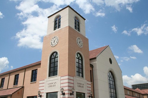
New Library in River Oaks is LEED Silver. Dave at neoHOUSTON went on a tour and posted a recap. Here are some of the vital stats, the full write-up is at: http://www.neohouston.com/2009/04/looscan-...eed-tour-recap/ if you're interested.
Building Info
-
Owner: City of Houston General Services Department, Houston Public Library
-
Architect: Jackson and Ryan Architects
-
Engineer: Walter P. Moore & Associates
-
MEP Engineer: I.A. Naman and Associates
-
Structural Engineer: Ingenium, Inc.
-
Interiors: Bennett Design Group
-
Contractor: Gilbane Construction Company
-
Project Size: 21,175 sq ft.
-
Total Project Cost: $5,576,500
-
Cost PSF: $263
-
Completion: March 2007
Pretty cool project overall, though they were really close to Gold, and I'm not sure why they didn't go for it...
-
Owner: City of Houston General Services Department, Houston Public Library
-
I don't want to see people at my office in shorts.
There are good alternatives, too, like linen pants. Think about what people wear on a golf course. It can look nice but be light and breathable.
-
I got an idea from the De Lange Conference last week, based on a speech by Antanas Mockus, the former mayor of Bolivia.
The background for the idea is described here: http://www.neohouston.com/2009/03/antanas-...ulated-society/
Take a look if you care to, I thought the whole idea of three dimensional regulatory policy was pretty interesting...
Anyway, the part that really got me thinking is when Mockus talked about addressing water shortages in Bogota not by trying to impose new regulations, but by advocating for lifestyle change. I was thinking of what we struggle with in Houston, and clearly the biggest environmental issue we face is heat.
Then I started thinking: when I'm around the house in the summer, I leave the thermostat at about 78 degrees, and I wear linen shorts and sandals most of the time. It's really comfortable, and my wife is especially appreciative since she gets cold easily. The problem is the office. I mean, when it's 98 degrees outside, wearing a suit is the pits. But for many of us, the office culture is unyielding on the dress code, no matter how climatically inappropriate it may be.
What if we created an initiative to have "Dress for the Weather Week" sometime this summer? Think of how much money businesses could save if they turned the temperature from 68 to 78 and let employees dress appropriately for it?
I know this is a cultural issue, and one that won't change overnight, but a city-wide event where we all dressed like we live in Texas for one week could fly, and if businesses did realize significant savings they might consider keeping it up. This could be especially beneficial for Houston businesses in the current market.
What do you think?
-
Went to the Urban Corridors discussion, it was pretty good. The complete recap including some more background on urban corridors is available at http://neohouston.wordpress.com/2009/02/26...rridors-debate/. Enjoy!
Part 1: The GoalsThe city is considering these two goals:
Committee Goal 1: The ordinance will ensure provision of adequate publicly accessible pedestrian realm in the corridors, particularly station areas.Committee Goal 2: The ordinance will facilitate the development over time of a built urban environment that is pedestrian and transit supportive.These goals seem to work pretty well. They're big and a little vague, but they work. There were also a set of guiding principles listed below these to add some clarification, if you'd like to see the complete statement you can view it as a PDF, here.
There was strong consensus that there were some important things missing. The following additional goal statements were offered up for discussion, with my comments underneath:
Suggested Goal 3 (from David Crossley): Design the ordinance so that street design complies with Context-Sensitive Solutions for urban areas.David is suggesting linking the design of the street and sidewalk together to form a more complete street, based on the recommendations of the Institute for Transportation Engineers. I couldn't agree with this idea more, I think the city would do well to replace their current design manual with the ITE manual.
Suggested Goal 4: Design the ordinance so that new streets use best practices of storm water managment, flood control, and light-imprint design.This one was suggested by a woman whose name I didn't catch, she said she was involved in HGAC's water quality efforts. I think there's merit here, certainly the street designs could better accommodate best practices in storm water management. The only problem I have with that is that it should be a city-wide effort, not limited to urban corridors.
Suggested Goal 5: Design the ordinance to place equal importance on the needs of cyclists.This was suggested by a man from Bike Houston. I think this is also a good idea, though it may not be the top priority of the corridor. I would place a greater emphasis on allowing bikes on the busses and trains themselves, and on providing bike racks! Honestly, if there are going to be parking requirements, these should include bicycle parking.
Suggested Goal 6 (from Joshua Sanders): Design the ordinance to ensure surface and subsurface improvements are done simultaneously when these new standards are implemented.Joshua Sanders, from Houstonians for Responsible Growth made this suggestion. I tend to agree, though I think this is something to include in the city's working policies rather than the ordinance itself.
Part 2: The Details
The next part of the discussion looked at the details of the urban corridors project, especially the design of the sidewalks.
Here is the City's recommended sidewalk design:

The big questions surrounding the sidewalk design came in three major categories:
1. Should the sidewalks be located strictly inside the right-of-way, or should they extend onto private property?
The crux of that debate is this: when there's not enough room for the desired sidewalk section (15′ from back of curb), should the city acquire additional ROW, or should they city require developers to allow the sidewalks to be built on their property.
I think this one is pretty obvious. The city needs to acquire the ROW and own the sidewalks. There are plenty of reasons for this, not the least of which is control, consistency, and liability for accidents. These things are public concerns, and they need to reside in the public realm. Developers should be allowed to (and certainly would) tie in to the sidewalks with additional landscaping and open patios etc, but they don't need to have the responsibility for the main through way.
2. Who should build these sidewalks, and when?
This discussion centered whether or not the city should build these themselves, or whether the city should require property owners to build these the same way they require parking lots to be built whenever they require a building permit. There was also quite a bit of discussion as to whether METRO should be the one to build them, since they would be tearing up the streets that form the heart of the urban corridors to put in the transit lines.
This debate is valid, and it's frustrating. There's no reason for the City not to fund sidewalks, they're every bit as important to the functionality and health of the City as sewer pipes and major thoroughfares, and as one participant in the discussion pointed out, they are cheap in comparison to other kinds of infrastructure.
There are limits to the City's funding, however. Currently property owners are required to build 4′ sidewalks and parking lots whenever they develop or redevelop a property (anything requiring a building permit). Why not just continue that pattern? I think if the parking requirements were dropped in urban corridors, the city could reasonable ask for the new, enhanced sidewalks to be funded by the property owner upon redevelopment. The problem is, that means it will be a long, long time before there's any consistent span of sidewalk space, and that destroys the purpose of this sidewalk design.
The point about METRO paying for these was well received, the problem is METRO claims they have no money to do this, and the consent agreement they have with the City does not require them to, as it holds METRO only to replace the sidewalks that existed before the street was rebuilt. That's a shame, but I'm not sure there's a lot that can be done about it now.
3. Is this the right design for the sidewalk?
This discussion really didn't last long enough, I think this is the most important question. We can come up with a funding mechanism, we can find a policy that Houstonians will support, and we can get these built. HOWEVER, if we want them to work properly we MUST build them RIGHT. If we're not going to do it right, we shouldn't do it at all.
Now, the basic section is good, but I think there's a major problem here: 5′ is not sufficient through-way for an urban sidewalk. The recommended section is very vauge about how the other 10′ in the sidewalk section are to be used. Part of it will be used for tree planters, but not all 10 feet. Part of it can become on-street parking, that's usually about 8′. Part of it can become 'sidewalk cafe' seating.
In order for the sidewalks to accomplish their goal (allowing people the choice of walking for local transportation) they need to have at least a 6′ clear zone, and an 8′ clear zone would be better. This zone doesn't have to be perfectly straight, marked off with lasers, anything like that, but there needs to be a continuous space at least 6′ wide that stays clear of any permanent (ie signs / poles) or semi permanent (ie cafe tables) barriers.
The other problem with the 5′ through-way is that the city is proposing to offer developers zero setback from these sidewalks. More specifically, they're suggesting that buildings be allowed 15′ from the back of the curb (in case the city elects not to buy the ROW and the sidewalk zone is on the private property), but the end result is the same.
Now, I would ordinarily be singing and dancing about how great it is to get zero setbacks. Setbacks are a waste of time, money, and valuable property, and we don't need them. However, the city needs to either WIDEN the profile of their sidewalk zone (and acquire the additional ROW) to leave a 2′ building edge zone, or require a 2′ setback. The reason for this is pretty simple: people generally won't walk within 2 feet of a wall.
That 2 foot buffer between the through-zone and the building doesn't need to be lost space. It can have plantings, it can have benches or displays, whatever really. But there needs to be at least 2 feet of space between the edge of the through way and any walls.
Another solution to this would be to design the sidewalk standard so that the 'buffer zone' is either 7 or 8 feet depending on the size of the street (enough to accomodate an on-street parking lane), the 'through way' is immediately adjacent to this, and the remainder of the sidewalk section is 'flex space' which can be used for outdoor seating, etc. However, when you take into consideration the additional width (1-3′) the city really needs in the through-way, this is basically the same as just defining an 'edge zone' as the 2 feet between the through way and the building line.
What say you, is the city's sidewalk idea brilliant or bogus?
-
Hey all, I thought this was something you might enjoy:
Today I had the chance to attend the ULI-Houston Mayoral Candidate Forum. Since this was a members-only event for ULI, most of Houston didn't get to be there (which is a shame, really, because it was a great event!). So, knowing my readers would probably have appreciated knowing what was discussed, I took the best notes I could. Present at the forum were the four 'leading' mayoral candidates for 2009. I've listed them below, in alphabetical order, with brief bios condensed from the ULI report.Peter Brown: Currently an at-large councilman, Peter Brown is a Fellow of the American Institute of Architects, a US Army Veteran, and has been an advocate for proactive planning and Smart Growth. He is on the board of Trees for Houston, the Main Street Coalition, and Blueprint Houston among others.
Gene Locke: Gene Locke is a Texas Super Lawyer, practicing with Andrews Kurth LLP in Houston. He was a key figure in the development of Minute Maid Park, Reliant Stadium, and the Toyota Center, and is also a special council to METRO and the Port of Houston. Locke served as city attorney for Bob Lanier.
Roy Morales: Lt. Colonel Roy Morales, US Air Force Retired, is a 23 year veteran. He worked with NASA as director of operations for the space shuttle operations division in California. Morales is a Harris County School Trustee, responsible for setting school tax rates.
Annise Parker: Anise Parker has been the City Controller for the last 5 years, and was on the City Council before that. She was born and raised in Houston, attended Rice University, and worked in the oil and gas industry for 20 years.
The forum was moderated by Rod Rice from KUHF, and was divided into these six segments:
- Opening Statements
- Question 1, regarding light-rail and TOD
- Question 2, regarding economic development incentives
- Question 3, regarding housing, sustainability, and infrastructure
- Question 4, regarding development regulation
- Closing Statements
I've written a summary of what each candidate had to say. For the sake of comparing their ideas I've listed them in alphabetical order throughout, though in the forum they cycled through the candidates in a different order for each question.
The rest is too much to fit in the window here, but you can read it all on my blog at: http://neohouston.wordpress.com/2009/02/19...andidate-forum/.
I hope this is helpful for those interested in the mayoral race!
- Opening Statements
-
But $18,000,000,000? That's huge. Aren't there ridership projections? I would doubt that the DFW to San Antonio would be cost-justified. The phrase "it would be nice" comes up a lot about this train, but is it really worth it? I could think of a lot more "it would be nice"s which cost a lot less but would still benefit Texas.
We spent almost $3 Billion to widen ~20 miles of Katy Freeway. Why does $18 billion to build ~400 miles of high speed rail seem too high?
-
For those who missed it, you might like to read some of the conversation that's been going on about streetcars in Houston. Kuff had a good recap page with links at: http://www.offthekuff.com/mt/archives2/2009/01/013163.html.
I posted an update to my concept today, with a look at how you could bridge the gap roughly at W.Gray and Waugh, and fill in the street network so that W. Gray and Peden become a one-way pair with a streetcar into downtown.

The post is at: http://neohouston.wordpress.com/2009/02/09...-redevelopment/
There are more pics and some details on how it could work on the blog. Check it out if you're interested, I hope you enjoy the read.
-
-
Dave at neoHOUSTON shared a recap of a walking tour of the Historic Sixth ward today, it sounded pretty cool...
"Overall, it was a fantastic tour, and it was well worth $10. Starting next month, if you walk, ride your bike, or take public transportation to the tour, you receive a $2 discount. And members of GHPA only have to pay $7 per tour. I highly recommend going to the next walking tour on February 15th at 2pm, which will meet downtown outside the Bank of America building and will cover 20th architecture along Main Street."
You guys might enjoy reading his post: http://neohouston.wordpress.com/2009/01/14...ric-sixth-ward/
-
Thanks for the link!
The current financial meltdown is illustrating a point that has been made over and over again in our history, but which has been handled differently many times over:
America is worse off when government takes over an industry, or when private enterprises become monopolies.
The best, easiest illustration of this is the anti-trust rulings against the Bell Telephone System that lead to the breakup of the old communications monopoly. Immediately following the breakup of Ma Bell we entered into a new era whose primary characteristic has been the rapid, exponential increase in the quality, diversity, and availability of communications technology, not least of which is the Internet.
Transportation should not be the exclusive purvey of government, and as long as it is we the people will be limited to what politicians can haggle for instead of what the free market could deliver.
To be clear, local neighborhood streets and the like would have to be provided by municipalities, as there is no way to regulate access to these networks without compromising their entire function. But if freeways, freight trains, passenger trains, airlines, bus lines, etc were all competing in an open marketplace, I strongly believe you'd see a rapid increase in the availability of new transportation services and systems in urban areas, and noticeable improvements to existing services.
PS. Update:
Of course the cash crisis for exurban families has improved since gas prices have gone down. I think the important point the documentary makes is that when we become too dependent on the automobile there's a breaking point at which our options for coping are all pretty unattractive.
-
Did I miss something here? $4 a day is $1000 a YEAR, versus $9700 a year for an automobile, and you DON'T see the benefit? Well said.
-
Seriously,
His blog hasn't been updated since mid-summer. Anyone know what's up? I'm missing my fix of intermodality...
-
not sure the public should be getting into the business of providing parking for apartments and businesses. if a business wants to open and get as much business as possible, they need to provide parking and/or work with other businesses to provide easy access to parking. i know i wouldn't pay $5 for parking to go to cyclone anaya's, etc.
The public is in the business of providing infrastructure, and that's what parking is. Centralized parking, combined with good on-street parking design, creates an economic boost for the surrounding area. That creates opportunities for businesses where they didn't exist before, the same way that building a road or a sewer line does.
I don't think the city should be building residential parking, but I do think that they could build centralized parking targeted at visitors to the area, mainly people who will shop or play in the area, and that would significantly improve the ability of small shops to operate.
The point is not to provide parking for Cyclone Anayas though, that's really beyond the practical radius of McGowen. The idea is to provide parking and some aesthetic improvements in an area that's kind of dead now, an area that's critical as a gateway into Midtown via the rail, and use those investments to help complete the transformation of the area.
In the end its a good investment, the ammount of redevelopment activity that would follow would yield a long-term sustainable profit to the city. The challenge is, these returns are over a long enough time-frame that private sector money alone is typically uninterested. Only the big national players with access to better debt are building projects that require massive infrastrucutre investments themselves (like Regent's Square).
-
That is ridiculous. If anything, Houston has so many different places that are well-suited for urban living that no one neighborhood has been able to achieve enough market share to support a total urban transformation. Think of all the tens of thousands of new single-family homes and townhomes developed inside the loop (Downtown, Uptown, Midtown, Memorial Heights, Montrose, Upper Kirby, West U., Bellaire, Rice Military, Heights, Museum District, Cottage Grove, 1st Ward, 4th Ward, East End, 3rd Ward). Houston is not short of urban development by any measure; it is just occuring so many different places all at once that it's sometimes hard to notice the forest from the trees.
Frankly, it seems to me as though Midtown has been passed over relative to many other areas. And it has completely lost its momentum over the past year, with numerous project cancellations. I know of six multifamily projects in Midtown that are dead or dying. Meanwhile, townhome construction is no longer feasible. I would definitely argue that Uptown, Montrose, Rice Military, Upper Kirby, the Museum District, or even Washington Avenue is further along at this point as compared to Midtown.
It helps a lot that other parts of the urban core have many more contiguous parcels of land under the same owner. Midtown may be a grid, but insofar as it results in fractured ownership, it is more hurtful of development than helpful.
Empty rhetoric. Any investment can go sour. Also, residential development in Midtown is only displacing residents from another neighborhood that they otherwise would've lived in. Surely they would have still had retail expenditures, even if they had moved to Uptown rather than Midtown.
You need to realize that Sim Cityism is a poor substitute for humanism or fiscal realism.
Alright, let me clarify what I mean by dense urban living:
Montrose isn't dense urban living in my book, it's moderately dense compared to suburbia, but it's still pretty low density overall. Yes, there are some corners here and there where you start to have a bit of density, but not a lot.
I love Montrose, but it's only scratching the surface of a dense urban neighborhood. And, specifically, I think Montrose adds a lot of value to places like Midtown and Upper Kirby specifically because it is *not* as dense as those areas.
Now, you mention large parcels and fractured ownership etc... It's true that conventional development occurs more easily on these large lots. My point is, that's not the crap that constitutes urban in general. For instance, AMLI Memorial Heights: not urban. Camden Midtown: barely urban. The reason is, any genuine urban development is going to be AT LEAST equally accomodating to pedestrians and automobiles, and good urban development will accomodate cars discretely while being strongly oriented to pedestrians.
Post Midtown is urban. Camden Midtown, barely. Calais at Courtland Square, not urban. Dense, but not urban. Parts of downtown are urban.
The point is, when you have the street network as it is in Midtown, nearly anything that happens will be more urban by nature than anything that goes on out in the burbs, or in the 'large block' areas like Uptown or Upper Kirby.
If walking isn't at least a comfortable, practical choice, and ideally the best choice for short trips, then an area is not urban.
Also, as far as I'm concerned, if an area isn't transit supportive and at least marginally transit-oriented, it still barely qualifies as urban.
For Midtown likely that you can get to work without driving. Maybe you don't, but you could. But in Montrose? Unlikely. Possible, yes, but not likely. Upper Kirby? Maybe. Washington Avenue, unlikely. Uptown, possible. That's another major criteria of whether an area can sustain a dense residential population.
Lastly, the momentum in Midtown has started to run out for several reasons, among which fratured land ownership is only one. The general tightening of the credit market is a much bigger problem. Undesirable land uses (like the two bus stations on Main and Gray), plus massive derelicts (like "central bank") hurt other areas more locally.
But the biggest problem is parking. It's just about impossible to afford the construction cost of all the parking that is typically required in an urban setting. More specifically, it's impossible to do it at the rent levels that Houston currently supports. Parking regulations drive up the cost of housing in urban areas and make them less competitive.
Also, the parking requirements are much higher than what is really needed in a development. Take Post Midtown, where I live, as an example again. That complex was built taking advantage of the 'CBD' designation to allow just one parking space per unit, instead of the normal ratio ranging from 1.3 to 2 spaces per unit (depending on bedroom configuration). The complex has a 6 level garage. I've only ever had to park on level 5 one time. Once. Ever. The bottom level of the garage is used for visitors and retailers, and it stays pretty busy, but there's still a space available more often than not. Clearly, that parking ratio works. Why then, do we require higher ratios by law, and only allow variances after a brutal approval process?
What I'm suggesting is that a combination of public groups work together to invest in centralized parking in Midtown, and then cover it up with a public park.
If they would do this, instead of having 3-5 blocks of significant redevelopment, we'd likely end up with 10-20 blocks undergoing significant transformation.
This centralized parking could serve all the retail and commercial uses in the area, and residential complexes (like Camden Travis) could continue to serve their own internal parking needs.
The idea that people would just live somewhere else is somewhat true. My point is, it would be better for more people to have the opportunity to live in a nice environment close to their place of employment. Midtown's location between Downtown and TMC is unbeatable for access to employment. Could those people live in sugarland instead? Sure. But it would benefit everyone if the growth of the city were steered towards areas that would not just pump 100% of their traffic onto the already overloaded freeway system, but make use of the ample local street network and mass transit that already is on the ground.
-
Chevron is already buying the old YMCA downtown. YMCA already has plans for a replacement facitlity near the Pierce Elevated. The city has nothing to do with this.
That's good info, I didn't know about Chevron's plans.
I'm aware that the city isn't involved in any of this, it's purely my concept of what would be ideal in the area.
As far as what I *do* know, the Fire Museum will likely end up having a plaza area in front, facing onto Hadley street.
And the superblock is half owned by the public. I'm pretty sure it's the redevelopment authority. I'm pretty involved with the urban planning committee for the Midtown Management District, they talk about the superblock a lot, but always in the context of working with the redevelopment authority and Camden.


Houston Property Taxes
in Houston Real Estate
Posted
People can be so defensive
For what it's worth, I'm not trying to argue anything about whether I like Houston, whether it's a good place to live, or whether you can get a nice house here.
I'm specifically ONLY interested in the way that the tax structure impacts the purchasing power of buyers in Houston, and therefore leads to lower listing prices than we would have with lower taxes.
@RedScare: I added this comment at the end of the post, and it adresses the same point you made.