

Whitesman
-
Posts
44 -
Joined
-
Last visited
Content Type
Profiles
Forums
Events
Posts posted by Whitesman
-
-
Does anyone know where the archives or files of the old Houston Press Newspapers are located??
If I remember correctly, didn't the Chronicle buy them out---in 1964???
Online files for the Chronicle doesn't go back far enough for what I am researching about-- before the 1950's.
-
Great band. I still have their first three Lp's. There's been some discussion here about them in the past. Check out Rick Campbell's blog. He wrote a piece about them.
You can get their first 2 albums on CD. It's called Another Time, Another Place. Sadly the only thing it's missing is their single, Hey Mister.
I have them on LP, and they are on CD's---also the singles they released are on one of their cds.
Check out the Rob Landes webpage. He was the organist for Fever Tree.
-
Switch to the North side for a minute, and tell me the name of the kiddie park on North Shepherd, just North of the old Sears store. It was on the West side of North Shepherd, but I forget the cross street - it wasn't Lehman, but it was close to it. Now they had some great ponies, and did riding lessons in a big pen as well. lots of fun, and if memory serves me, they had a red & white striped big top tent. I always thought it was a branch of Peppermint Park. Anyone ever go there ?? Photos ??
I remember going there.
It had pony rides and also some trampolines set into the ground.
I remember the red/white tent and I think it was Playland Park... but I could be wrong on the name.
I think it was just north of Pinemont????....it had lots of trees if I remember correctly.
-
I have been advised by one of our patrol units that he responded to a call yesterday, where a male was selling alarm systems in our area. The story which the male gave this officer sounded "fishy" and he verified some information which could be helpful to others.
When approached by the officer, the male stated that he was selling home alarm systems for APX Alarm Security Solutions and was licensed and permitted by the City of Houston to sell the alarms. The City of Houston DOES NOT license, permit or endorse anyone or any company to sell alarm systems or any other item! He apparently misrepresents himself as being endorsed by the city with the hopes that this information could influence someone's opinion to purchase an alarm system at an expensive cost.
This officer spoke to one of our divisions which in turn spoke to someone at the Texas Department of Public Safety which investigates and regulates alarm companies. The person at DPS stated that alarm companies in Texas must have a permit to sell systems from the State of Texas, not the City of Houston, and they must be able to provide a copy of the permit to you.
Remember, the City of Houston does not endorse, permit or license any company to sell any product door to door! All City of Houston employees who may come to your door will have a uniform and/or an id card with the City of Houston Seal, their photo and name and title. Also, for consumer safety reasons, use a reputable company which you know and also contact the Better Business Bureau before allowing a contractor to work on your house.
Please pass this along to other residents in your neighborhood and advise them "buyer beware!"
Thank you for your help with this matter.
Houston Police Heights Storefront
1127 N. Shepherd
Houston, Texas 77008
Phone (713) 803-1151
Fax (713) 803-1155
They are stating they are working with the police department and have their co-operation. And the first words out of their lips......"We are NOT selling anything", the guy insisted to speak with the home owner even after I told him we were not interested in buying !!!
Once he got in the door he started with they need to verify who the home owner was and that (specific ) neighbor gave us your name, and just had the system installed( the installer is in the neighborhood and can set up in about an hour after you sign up). ...well let's say ....he was very good at his sales pitch.

-
What a disappointment. While it's nice to see the building gone (because it really was in icky shape), I have to agree on the land use.
Went by there this morning and took this photo.
Looks like it will just be a credit union building.
http://i119.photobucket.com/albums/o135/Wh...rdoakforest.jpg

-
That house was cobbled together and contains both 19th and 20th century elements. It is on a piece of land that was owned by Mathias Stuer in the 19th century. Mathias was a German farmer who also ran a store along there when the road still followed the RR tracks. That area was called Eureka until the 1940s because of the Eureka textile and lumber Mills that were there from 1866-1875. The house used to sit along the old road, but was moved when they re-routed the highway in the early 1930s. Back then it belonged to the Zahn family. A Zahn daughter married a man named Bruns and inherited the house. The house still belongs to the Bruns family. It used to be a farm. There is still an old windmill on the property.
Thanks for all the replies, and was just wondering ---why it would have 2 doors on the front side of the house??
-
Found this old house and took some photos and was wondering any experts on the forum could estimate the year this one was built.
It has a upper window on the one side that I could see, so it looks to me like a 2 story structure.
http://i119.photobucket.com/albums/o135/Whitesman/frontview2.jpg
-
Yes, Whataburger was in the hallway to the left of Wards (now Target.) If you were approaching Wards from inside the mall, you would turn left before you went into the store. It was somewhere near the Army recruiting office.
Oh, and someone else mentioned a grocery store. There was a Weingartens located near where the skating rink is now.
It was closed some time in the 70s and United Jewelers took its place. I think this was before Lord & Taylor was built.
I remember that the Mall was from Sears to where Wards used to be( before Wards was built) That was all the mall. Wards was built and then they added the automotive center next to Wards.
Then they made the mall into a "T" shape in the early 70's, and there was a Coin Shop on the right side almost to the end of the "T".
They lengthened the "T" and had a food court at the end on another "T" and there was a Game place there also.This was in the mid to late 80's.
Then they started a real remodel and adding stores to the west side of the mall. And on the east side of the mall some new stores came in and took up lots of the old parking lot areas.
-
Just FYI! I think I am starting to get the picture, no pun intended, about why I am not seeing many or any pictures of the Camp Logan Mutiny of 1917 I have been asking about i.e. the Camp Logan mutineers courts martial proceedings, either the 1st or subsequent courts martial, the gallows, and/or photos of the executions, burning of the gallows after the executions and possibly the graves at Fort Sam Houston where the mutineers were buried. It's because there are either no photos of the kind that I have been looking for, they are being so closely held by the Army or they are so obscure that they are hard to come by.
I have found the people on this website to be some of the best researches you will find anywhere yet so few or maybe none of those photos have turned up by HAIF contributors. I know that some of those photos exist because I have viewed the video of the PBS special on this topic and have seen some of them.
To carry this a step further many years ago I read a copy of "The Night of Violence" by Robert V. Haynes and I remember even years ago having problems getting my hands on a copy of this book. Finally, I had to get a copy of this book through intra-library loan from the University of Michigan and I was living in LA at the time. Recently, I did a search for this out of print book and found it on Amazon.com used for upwards of $100 per copy which I purchased one. And, to my utter surprise there was not one photo in the entire book about, "The Houston Riot of 1917"! There were only 4 hand drawn maps of routes and related locations of the riot and rioters.
So, once again, I ask members of HAIF to contribute any of the photos of interest I have mentioned if they have them in their possession. Thank you.
CampLogan1917

I also have the "Mutiny" book, and another book about Memorial Park, which has a chapter about the riots, but no pictures, just a map of the march route. I also have been searching and have not found any source or any of the pictures, for this event.
Maybe the guy who made the Buffalo Soldier video, Mike Kaliski ,or the media website who hosted the making of the video, bauhausmedia dot com would know ???
The producer must have found the pictures somewhere, to insert into the video.
-
Interesting research & pictures, has anyone tried looking at the Sanborn Insurance Maps on microfilm? I've found those to be of great help when trying to identify property boundaries & owner names. I forget what year they go back to, though. Microfilms can be found along with other materials at The Texas Room at Julia Ideson Library downtown (has a fantastic staff, always eager to lead you in the right direction). The Clayton Geneaology Library in the Med Center is good, too, for Houston research. Nice to know there is a Camp Logan marker, looks like it's new. That feed/water tower is old, I think it could possibly be from that era. I've always noticed how that area's bayou's have been left natural, they are very thick and winding. (Woodway near 610 loop, I-10 at Chimney Rock) I've always wondered why the HPD horse stables are in that particular location, seems odd to me, next to the freeway, (I know, the frwy came later), skinny long piece of land. Thought they would be closer to the polo horse stables. Perhaps the stables have a history linked to the above topics. Because of working in the industry, I agree with the pipeline statement, most chemical multi-lines are kept clear of brush, they have wide right-of-ways, but there are some (mostly single) lines that are sometimes hard to access. IMO Winter-time in this city is the best time to hunt for hidden structures, with the absence of jungle vegetation.
Up until the early 1960's, you could rent a horse to go riding on the trails, through Memorial Park( before mountain bikes were popular), and I believe the stables were taken over by the Police Dept.afterwards, for their horses.
Just a thought on the water/tank building.. if the water tower is newer than the Camp, why would someone have built it,after Camp Logan, in an area that the owner had given the land to the city, that would strickly be used as park area built in 1925??
Whitesman
-
Whitesman,
Thank you! That's a great photo of the Texas Historical Commission Camp Logan Historical Marker. Where exactly did you find that marker? I looked but it but I couldn't find it.
Thanks, again.

CampLogan1917
CampLogan1917,
I did some extra searching on the riot, and remembered reading, that blacks were called "Buffalo Soldiers", so I Googled "Buffalo Soldier Mutiny" and some good hits came up.
One even has a short film made of the riot, by Mike Kaliski, and you can download the film for about 10 dollars.
"Buffalo Soldier Mutiny"
on the following website:
www dot zipidee dot com
-
Whitesman,
Thank you! That's a great photo of the Texas Historical Commission Camp Logan Historical Marker. Where exactly did you find that marker? I looked but it but I couldn't find it.
Thanks, again.
CampLogan1917
The marker is at Arnot and Haskell in a small section between the streets.
-
Nice article, . .......I'm still trying to track down a photo of the Camp Logan Historical Marker but no luck so far.
CampLogan1917
This should help.

-
The GPS coordinates that my phone reported for this location to be 29.7628N, 95.4584W which I turned into a GoogleEarth satellite map... I'm very curious to the full nature and history of the path that leads down through the middle of this stretch of Memorial Park. While the path clearly goes very close to these old remants of Camp Logan, they don't go close enough to what I'd call a 'driveway' to them nor is the path efficient enough to be considered a maintenance path to the pipeline and telephone pole lines that slice through the very bottom (south) edge of this park land.

.
The road was used for the archery range and right after the archery range is a bigger clearing where a car could turn around and go back up the one lane dirt/crushed shell road. There is one or two picnic tables left from the archery range days and you can find parts, and full arrows all over that area.Parts of the where you stood to shoot the arrows( like the gun shooting practice stalls you see on TV) and the target holders are still in the woods.
There is a pathway that goes in front of the structure , but has been overgrown with brush for many years.
-
Whitesman,
What fabulous 1st hand research on the ruins of Camp Logan you did. I was fascinated by the photos and your words describing your search and adventure along with the topo map, Google Map and your insights about something that existed so long ago.
CampLogan1917
Credit also goes to Mr. Jackson who had his own adventure, locating the structure with excellent pictures, topo map,and his insights on the structure..
According to few people, who know bricks and have looked at some pictures that I took,of the bricks,morter thickness, and the structure , the bricks and this structure are at least 80-100 years old. And indeed ,could have been past the Camp Logan time.
But why build a water tank on the edge of a piece of land that was to be used for a part of a park??
Remember.... 610 and I-10 were not built in 1925, and this section, was a main park of the park and of the Camp, even though the online "Gill" map doesn't include this area.
A couple of different sources say the main camp developed area , which is most of the online map,( ..."Camp site proper was 2000 acres with the Remount Depot"-- From the book "Memorial Park-A Priceless Legacy") was just part of the complete camp area.
The structure could have been made for the National Guard camp that Camp Logan took over, or for Camp Logans Remount Depot. The last picture Mr. Jackson took in his post shows very well the type of bricks of this storage/water tank structure.
Can anyone else, who knows about brick laying, give an approximate date of this water tank/storage building, by looking at the pictures Mr. Jackson took of this structure???
-
I went out to investigate the old Camp Logan remains mentioned in the old newspaper article about them possibly being in the abandoned stretch of Memorial Park just west of the 610 Loop West. I went this morning while the weather was nice and wasn't too hot. Finding the trail and getting started was very easy, and with a GPS phone with satellite imagery with me, I guess you could say I was cheating by looking for the reported remains. I got to about approximately 80 yards of the 100 yard path leading down the turn off, when large freshly downed trees made it impossible to continue without drifting off newspaper article described path considerably..

[ Looking at gate, N toward Woodway.]

[ Looking S toward downed trees.]
After turning to the west toward the reported "path" and clearing, which at this point was only a very short slightly downhill jog toward the bayou, I had to continue skimming the often sandy bayou beach until I reached a point along the bayou where there was what appeared to be a dry stream bed of some type leading to the bayou. It was at this point that the Camp Logan remains were only a short walk away. Once passing the dry stream bed, the embankment climbed steeply up a hill in the S/SSE direction where the remains were located...

[ Looking SE toward the back side of the Camp Logan remains. The front and front door of both the feed tank (or whatever it is) and the shed next to it face directly toward the path, provided I had been able to stay on the path. You can see the straight line in the satellite imagery that make up the walking path, but Hurricane Ike clearly hasn't been nice to these parts, with the path far harder follow and make out this deep into the forrest. ]

[ Closer shot of behind remnants...]

[ Side of shed next to feed tank.]

[ Front door of shed next to feed tank.]

[ Inside the shed next to the feed tank. The milk carton is a sure sign that others have visited here, or even tried to live here.]


[ Camera facing down inside bricked base of feed tank toward front door.]
Well, I was hoping for myself to have a clearer idea whether or not I believed this to be the last remains of Camp Logan. My hunch tells me that these are NOT the remains of Camp Logan, but more likely the remains of another property owners storage shed and feed tank just west of the old Camp Logan camp and property. We know the fairly precise boundaries of the old Camp Logan training base and it's all been documented in carefully drawn out maps, and I have a hard time believing that this area, this far from Camp Logan central, is connected to it in any way. It's certainly possible..
The GPS coordinates that my phone reported for this location to be 29.7628N, 95.4584W which I turned into a GoogleEarth satellite map... I'm very curious to the full nature and history of the path that leads down through the middle of this stretch of Memorial Park. While the path clearly goes very close to these old remants of Camp Logan, they don't go close enough to what I'd call a 'driveway' to them nor is the path efficient enough to be considered a maintenance path to the pipeline and telephone pole lines that slice through the very bottom (south) edge of this park land.

I also found this topographic map on Microsoft TerraServer that shows the land as it was topo'd back in 1982, so 26 years ago and counting, and I found it interesting that the topographic map clearly shows the path going south for a good distance before the map fails to continue drawing it, but the location of a structure is clearly shown and identifies it at the top of a hill. The part that is strange about this is that the structure indicated shows it immediately next to and at the end of the path, yet the current location is considerably further west and slightly north of this location. Notice also the small 'lake' shown just south of the bayou right above the "50" foot elevation marker, yet this current location is home to tennis courts and condo's along the posh Riverway Drive.
The structure on the topo map is (was) a pavillion,was burned down, used for the archery range that was used until the early 1980's. The hotel across the bayou (directly south) was getting overshot arrows in their parking lot so they had that area of the park shut down as it was in need of repairs due to bank erosion.
___________________________________________
Acorrding to Louis F. Aulbach ,about Camp Logan:
The developed area of Camp Logan was 3002 acres, within a tract of 9560 acres.
A remount depot was constructed just west of the main camp.
A rifle range was built 8 miles west on Hillendahl Rd.
Paved roads were oyster shell or cinder.
____________________________________
The downed trees blocked your way to see the pavillion on the right side of the path, (the topo map shows it correctly.)
The archery range was on the west side of the trail on the north side of the buned down pavillion.Under the leave covering of the path you were on is remnants of oyster shell roadways that are all over that secluded section.
The area is just west of the main camp and since there is a large water tank constructed there, would have been a good place for an extra remount depot where horses could get water pumped up from the bayou right behind the water tank.There is a small flat concrete slab behind the tank which could have held the pump. The area was pretty much treeless 90 years ago and was farmland, so an area, off the main camp would be good to have some extra horses. Memorial park is just about 1500 acres. According to "Memorial Park A Priceless legacy, Camp Logan covered over 7500 acres in size.
-
When I was doing my book on Houston streetcars I really wanted to find a photo of the streetcar turning loop at Camp Logan, but never found one. It was located at the edge of the camp near the corner of Ariel and Cohn streets, apparently across from the camp YMCA building. Surely some soldier took a snapshot of the streetcar. If anyone has such a photo I would love to see it.
Anyone know the location or have a picture of where the Camp Logan Drugstore was located at???
-
The above picture is not the last structure from the Camp.On August 23, 1917, two white policemen arrested a black soldier for interfering with their arrest of a black woman. When a black MP inquired about the soldier's arrest, words were exchanged, & one of the policemen struck the MP. The MP fled; & while fleeing, the MP was fired upon. The MP was pursued into an unoccupied house, where he was arrested & brought to police headquarters. Despite a quick & unhindered release, a rumor rapidly reached Camp Logan that the MP had been shot & killed. After several minutes of mounting tension, the rumor mill brought word to camp that the MP was in fact alive but being held unlawfully. After intense debate, a group of soldiers conclude to march onto the police station in Fourth Ward & secure the MP's release. If the police could assault model soldiers like the military police, they reasoned, none of them were safe from abuse. Realizing something foul was afoot, the white officers of the company ordered the collection of all rifles & loose ammunition. During this process, word of an approaching white mob struck fear into the hearts of the men. In a wild scurry to defend themselves, the soldiers rushed into the supply tents, grabbed rifles & ammunition, & then embarked on a two-hour march into the city, hoping to curb the mob. The white officers found it impossible to restore order. Over a 100 armed soldiers marched into the Fourth Ward, where they encountered the mob: members of which consisted of Klansmen & supporters, police officers, & members of Houston's elite white class, who saw armed blacks as a threat to their ruling order. There was an intense exchange of fire, lasting for several minutes, which resulted in the death of many people. The structure in the picture was the last remains from Camp Logan but it is gone, too, now.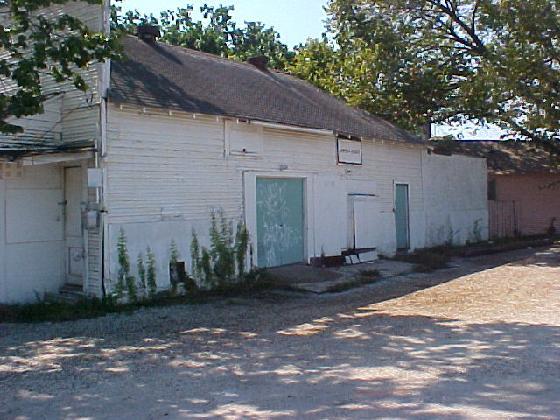
CampLogan1917
From this old Houston Post article below,I had found,this water tank and brick structure was still intact as of earlier this year (2008), I took a few pictures of it and it IS still there.
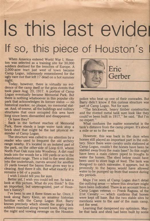
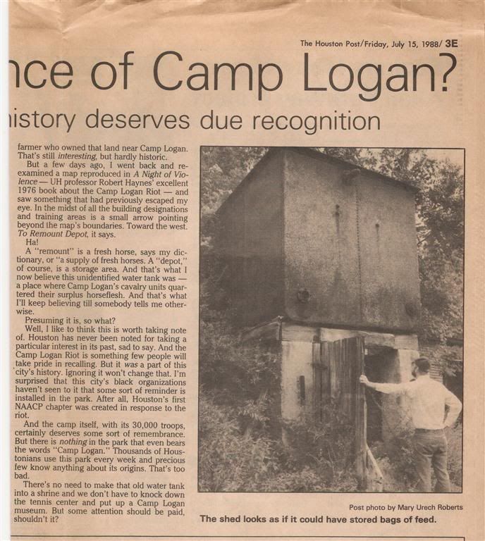
I had emailed the author of this article and he stated that a few "experts", looked at the structure, but no final conclusion was made,as to if it was or was not , a Camp structure.
In the thread of Camp Logan pictures I posted a link to my 40+ Camp Logan postcard/pictures on my Photobucket site.


-
Am I the only one that remembers the blue awnings on the Foleys arches, and the aztez calendar logo on the mall doors and canvas coverings?
I remember them also.
Northwest Mall and Almeda Mall were built by the same builders ( I believe) and had basicly the same stores in them when they first opened up. Both were built around the same time. The last time I walked around all of NW Mall the 2 fountains ( the center one and a smaller one in front of where J. C. Penny's was, were covered up.
-
I've been reading Rick Campbell's blogs. Loved the blogs on Fever Tree. I was a big fan.
Me too... still got the LP's. I saw Fever Tree at the Living Eye on Silber Road way back.......Also the Moving Sidewalks, Billy Gibbons' band before ZZTop.
Great memories!!!
-
I suspect David Kaplan is the same guy who started this whole conversation a long time back. Countless kids who went to Houston schools in the 40s, 50s and early 60s had no problem with swimming in the nude at junior high school, and if they did have a problem with it they kept it to themselves, and they don't sit around whining about it now the way this guy Kaplan is doing.
I'm sorry he was embarrassed, but he needs to get over it. Good grief.
As I went to Black jr. high and Waltrip sr. high in the mid to late 1960's, swimming naked in the pool during a P.E. class was a mandatory thing, to learn how to do some basic swimming. I particulary didn't like it, but as it was "required" I did it and got over it.
I do remember 1 time where the boys were in the pool and the girls P.E. class started to come in with their coach. About a half dozen girls came in and then were quickly ushered out again. They had swimsuits on.
I bet those first few girls got a peek of the guys that were hanging on the diving board.

-
Camp Logan was a hastily assembled, temporary camp for training soldiers during WWI, and I seriously doubt that they would have a cemetery dedicated solely for the few soldiers that would have died during training or during treatment at Camp Logan Hospital. Since this was an Illinois Guardsman camp, any casualties would have, most likely, been returned home. Unlike Fort Sam Houston that has been around for 140 years (40 years at the time of WWI), Camp Logan existed less than two years and would have no need for a veterans/military cemetery.
Before it was a WW1 training camp, the area was a National Guard training camp. And the camp hospital building was in use until 1925. Agreed that most of the soldiers trained there were from Illinois, but many from the Houston/Galveston area also were trained there also.
-
When I was in highschool at Waltrip High School, I heard that there was a fall out shelter/bomb shelter under the football field. I dont know how true this is and I never got the chance to go through the "tunnel" that supposedly exsists. But if this does exsist It would be something to try and look at probably is well preserved.
I knew of some older guys who went to Waltrip when I was in grade school in the "fall out drill" days. Can't recall if they ever said about a underground shelter. But I think if the drills in the high schools were as often as the grade schools they would have said they went to the underground shelter instead of crouching under a desk.
If by possibility there is one the door to the tunnel would be in the swimming pool area. I remember there were many old locked and chained doors in the pool area... unusual for that time in the late 60's.
-
I read on another website that there was a Camp Logan Cemetary, just for the soldiers, about 1- 2 miles east of the camp location, close to where Blossum Street runs east/west.
Does anyone know any information about this cemetary??


Tradewinds Roller Rink At 5006 W. 34th St.
in Historic Houston
Posted
We went to Tradewinds and won actual Silver Dollars for different skating games. Used to have lots of fun roller skating there, getting snacks, talking with friends and hanging out.
Anybody else have memories of going there?