

dp2
-
Posts
98 -
Joined
-
Last visited
Content Type
Profiles
Forums
Events
Posts posted by dp2
-
-
I could be wrong, but get the impression that east/southbound 610 traffic to the Crosby Fwy will initially be directed via the feeder roads, 610 to I10 east then exit and u-turn under the freeway to the westbound feeder, and finally a right turn onto the Crosby feeder. Westbound will exit the Crosby Fwy to the feeder which then turns west and north to the 610 feeder. Cheaper and no lights or stop signs required, just signs. But that is just a guess.
IMHO the outlook for development out there has changed drastically in the last 2 years. It appears that a lot of the planned subdivision for Crosby and east were primarily entry level homes, and that segment was hard hit by the mortgage scams implosion. If Cap and Tax gets passed and the admin requires tougher emissions regs on refineries (there's an article in the Chron today on this) it could be a long time before that area really takes off.
-
I hope it's not another one of those cookie cutter home developments that already litter the landscape there.
We get it, you don't like the suburbs. No need to repeatedly spam every suburban section with your snotty snarks.
And I see that you're still pretending to be the LtAWACS from other forums (now CaptAWACS here) even though you were asked to quit impersonating him a few years ago. Why not get your own name instead of stealing someone else's?
-
Sorry, but I heard it from one of the local news channels a number of years ago, so if you call it fake, go ahead.
Burn in hell, Delay.
Sure. Or from wikiquotes. Just like with the racist statements 'heard a few years ago' and blamed on Rush Limbaugh that when finally a source was traced it turns out he never said it.
Just another political urban myth repeated among liberals that soon is considered fact, because, you know, everybody's heard about it.
-
Tom Delay was willing to fund light rail if it served SL (his district), but when metro declined and showed him his plans, he retaliated.
Fake story, but it isn't unusual for people to pull stuff out of their rear on the internet.
-
"My hump my hump my hump, my lovely speedy humps."
Actually they're called speed BUMPS.
-
That's what a lot of people said about the Houston Pavilions, a light rail system, the Astrodome and a lot of other things in Houston.
And Tootsie's monorail network, our 150-story world's tallest, Houston Olympics, downtown subways, Disney Katy...

I can't tell if that is AstroSnow covered hills or The Bolivar Ike Ride.
-
Thanks for the map, I found wards 1-6. But where is the Dave Ward?
-
Gondolas on waterways, huh?
Why not build a faux Venice? At least that would be something you don't see around here everyday.
Venice with pirates. And an Abominable Snowman Swamp Monster. And some Killer Bees.
-
Actually I agree with your analysis of what could be done along that part of Wpark, except for the quotes above - the empty utility lot is also a flood retention area and I imagine there are hoops to jump through to change that to a paved over area, I think part of the L-shaped utility land is within Bellaire, which has zoning laws and an aversion to high-density development, so there may not be as much acreage available as it appears, and the likelihood that the single family residential north of Bissonnet between Edloe and Kirby to Wpark will redevelop into anything other than the pricey townhome and million$ home gentrification that is already well under way seems remote.
But you have laid out a redevelopment/TOD scenario that would still result in less potential ridership and "activity centers" than already exist on Richmond (comparing all of Wpark Shepherd-610, and all of Richmond Shepherd-610). Applying your same TOD scenario to Richmond future growth there blows Wpark away. HGAC data and projections support that.
Flood retention can be dealt with in a number of ways, such as underground facilities used elsewhere in the area. Not that big a hurdle. As for Bellaire, one strategy would be to offer to buy up and convert a rundown problem complex elsewhere in the city in exchange for zoning changes to allow for new TOD multifamily in that L-shaped plot, perhaps with some sort of understanding that they will be upscale, etc. There are plenty of ways to skin a cat.
After studying the area again carefully in the last few weeks, I am increasingly underwhelmed with the claims of Richmond's 'potential'. Take out the Greenway Plaza area office complexes and it becomes inferior to the Washington corridor and likely others. And I'm not comparing Richmond to 'Westpark', I'm comparing Richmond to a hybrid that pulls in both sides of the fwy between Weslayan and Kirby and better serves the Greenway Plaza office complexes. The split platforms in the middle of a 6-lane artery is a horrid design that will slow pedestrian movement and be a negative factor that will drive off some riders. Such a lovely experience standing in the sun in the median at the crosswalks waiting to crosss 5-lanes of traffic (remember the turn lanes) with 3 at your back. In contrast climate-controlled ped corridors that don't involve crossing roads for most patrons and better station location in this area (not constrained by trying to fit into a narrow median) will increase ridership. Perhaps too much emphasis is being placed on this line being a high generator of riders, when in fact its role in long-term planning may be far more of a distributor to destinations. And without zoning it is pretty iffy to put too much faith on any single set of projections, given how just changing a few of the myriad of inputs can produce radically different result (in fact a range of near infinity.)
I'd be willing to wager that a neutral party preparing ridership estimates on the Richmond route and my proposal would find them to be roughly comparable in the short-term, and Richmond inferior by 2025 as more and more rail and express bus feeds this line, IF at least one of the services continues north up Post Oaks and connects with the NW Transit Center. This and the Main St. lines are going to be the primary ones for distributing transit users to the major employment centers, and THAT should be the primary factor in its route design. Other areas, such as Washington, Harrisburg, North, and west of 610 can focus more on residential TOD.
BTW, we shouldn't let the perceived negatives of routing down or along a freeway completely rule it out in some limited cases. Calgary's LRT has 230,000 riders daily on just 3 routes, but much (the majority?) of it is inside the median of expressways. However, these stations are served with grade-separated pedestrian connections, a key difference with locating in the median of Richmond. So a freeway isn't a barrier that dooms LRT, it just is a negative that can reduce the TOD effectiveness of stations. And again, not every section of the University line has to focus on high-density residential or cute mixed-use centers. They aren't necessarily an end to themselves, but simply options for increasing density and ridership.
this "exaggeration" as you call it is based on multiple conversations over the last 18 months with METRO planners, who admit maintaining current vehicular mobility and handling the future increased traffic from the Tollway at the nexus of the 610 feeder, Wpark, the 59 HOV entrance, and the Tollway exit while integrating LRT is a "challenge," who reiterated to me on July 18 that in fact crossing arms and lights would be a requirement if LRT has to turn across Wpark to the tunnel. If you have talked with them and they told you something different please let us know. Any "challenge" can be overcome, but even you allow for added congestion, which directly contradicts METRO's pledge to not reduce general mobility. And my posts on the UC LRT have dealt with the proposals that METRO has talked about publicly, not what they haven't, so I can't debate diesel trains with you b/c METRO says they're going to be electric.A slight increase in congestion in a single intersection doesn't in itself reduce general mobility, but rather is just one factor to use in assessing the project as a whole. Funny how when Metro decides to push one route then the alternatives become "Sooooooo inferior" and beset with "huge challenges." But should Metro change its mind, those problems on the new preferred route shift to being simply "A few issues our engineers will adjust for." Going back to the mid-street platforms (spread out over several blocks in some cases) I appreciate the ingenuity of trying to reduce edge takings, costs, and maintain the current number of through lanes, but the end result is still a somewhat, to employ a French phrase, half-assed rail line. It meets (barely) the criteria and restraints placed upon them in this corridor, but if Culberson wants to move the goalposts, let him help find a way to pay for it and let's do this right like it should have been done.
I'm also suggesting electric LRT, but Metro has put forth the idea of using diesel light-rail on the University Line as a cost-saving measure. Any shift from that is a recent change.
-
Unfortunately your analysis doesn't square with facts and what is actually there. Let's begin:
a couple of observations:From Kirby to the UP track, "Westpark" is already built out and it's not high density, nor is it likely to transform to high density. The strip centers between Kirby and Wesleyan are filled with businesses and the ROW runs behind them, and the owners of these centers and their business tenants are not likely to turn around toward the rail line since fwy feeder access sends thousands of vehicle-driving customers by them every day and the rail will not have enough stops along this route to deliver a fraction of that. They will lose some back of the building parking to the rail, but they will still retain enough space for deliveries to continue at the back of the centers.
There are a few 4-10 story office bldgs and an apartment complex between Wesleyan and 610 on the 59 feeder, but a lot of acreage is taken by a COH pumping facility and low-density bldgs like Fox TV and the Chronicle. Hard to see significant high-density development taking place in this area, although it has a bit more potential than points east.
A 300' long station at the SW corner of Westpark/Newcastle is within 1/4 mile of all 3 multi-family complexes (along Pin Oak) and all 3 midrise office bldgs to the south of Westpark. The adjacent nursery at the corner of Westpark and 610 is a prime location for office redevelopment. Immediately south of the station site is a primarily empty utility lot that could fit another large apartment complex (or better) if the relatively few utility items were shifted over towards their land along the RR tracks. There is also the potential to develop the empty L-shaped portion of the utility land south of the big facility and on the east side of Mulberry, again within walking distance (1/4 mile) and enough land for an apartment complex. On the north side of Westpark, all the multifamily, the Chronicle, and 2 of the 3 major office bldgs are within 1/4 mile, and part of the Chronicle property fronting 610 could possibly be redeveloped (let's see them put their money where their editorials are regarding density, redevelopment, and "corporate responsibility to the community." Ha!) Land swaps with utilities and businesses in order to create TOD's is not uncommon. Plus the potential for exisitng multifamily complexes to redevelop into denser 5-6 story blocks, too. The Richmond alignment through AO would skip all that in this segment.
Actually there is some potential for the low-rise around 59/Weslayan to redevelop as mid or high-rise office, especially with the high-profile Fwy visibility. Yes, running south of Westpark here has limited potential because you lose the larger number of destinations north of the freeway, which is why a station crossing 59 here with its ends extending beyond the fwy edges and with pedestrian outlets that bridge the intersections to reach all 4 corners maximizes ridership. It puts within 1/4 mile the hospital and almost all the employment along both sides of the fwy between the RR tracks and Edloe, as well as those around the Weslayan/Richmond intersection. A station there might be enough catalyst for the car dealer to move and redevelop the site.Between Kirby and Newcastle there is not enough acreage anywhere between 59 and Westpark to build highrise residential/commercial bldgs on the north side of Westpark, and the south side of the ROW has zero development potential b/c of existing high $$ low density neighborhoods, low density commercial development, West U owned land, and Centerpoint power stations, until you get west of Newcastle.These conditions are why the HGAC jobs/residents growth projections comparing Westpark and Richmond between Kirby and 610 predict Westpark falling further and further behind Richmond in both categories over the next 20+ yrs.
Of course a station at Greenway Plaza on the north side of the fwy and east of Edloe would hit what is easily the biggest employment hub, and serve with climate-controlled connections much better than the crappy and drawn out mid-street Richmond station proposal. It is one things for a mass of pedestrians to try and cross the single lanes of Main Street, quite another to cross the busy 3 lanes each way of Richmond. No need for redevelopment here, this is already one of the region's 10 largest employment centers. A pedestrian walkway across the freeway here isn't perfect, but it still would bring in some ridership from the multifamily complex south of Westpark that is within a 1/4 mile.
There is actually a lot of sites with redevelopment potential south of 59 between Edloe and Kirby. Apartments can be replaced with 5-6 story ones, light-industrial, strip centers, and low-rise office are all typical properties that are redeveloped. Connect to it with a station crossing 59 at an angle at Kirby (to serve all 4 corners) and a climate-controlled ped walkway from the east side of the Greenway Plaza station (that also connect the south side to GP itself) and you are guaranteed to see a good portion of that area north of Bissonett flip to TOD. You lose all of that by staying on Richmond, while a line straddling the north side of 59's frontage road can hit that and catch some of Richmond. Just as much redevelopment potential here (if implemented as I outline here, and a couple of days ago) as with the original proposal. But yes, staying on the south side on the abandoned SP ROW parallel to Westpark would be substantially inferior and lose a good bit of ridership in GP and along Richmond (too far to walk, even if climate-controlled.)
my 1st post on this forum, #506 on p.11, detailed as well as I can why rail on Westpark anywhere between Shepherd and 610 is a bad idea. In a nutshell I believe the "mission" of this area is to handle vehicle traffic coming off of 610, 59, and the Westpark Tollway (which is in its infancy as far as volume goes and it already puts 2-3000 vehicles/hr at the 610 feeder/Westpark and Wesleyan/Westpark intersections at peak AM/PM hrs), that both Westpark and the ROW are too close to 59 in this area to incorporate a slow 20 trains/hr circulator line at-grade, that if you "El" the whole line you lose the only advantage a Westpark alignment had - cost/mile and introduce unacceptable visual and noise impacts in the residential neighborhoods from Vassar south and from Edloe to the UP tracks.the whole idea of building a slow circulator line with a "high-speed" segment that doesn't stop even though passing neighborhoods, businesses, and apartments seems the opposite of what taxpayers would want for all the tax $$ being spent. placing the last station in GPlaza then no stations until at least 610/Post Oak would mean no one in any of the residential areas south of Westpark-east of 610 could utilize the train without driving to GPlaza or the Galleria and parking, which is a "lose-lose" outcome:
you're suggestion runs the rail where there are fewer actual and potential riders than other routes and then denies access to the train to whatever ridership the area might have had.
More exaggeration. First off, the turning radius for Metro's LRT's are 82'. If they chose to use NJT's diesel LRT's like Austin has that may increase to approx. 130-140'. The Metro ROW (abandoned SP railroad) is 50' wide (not counting another 50' to the fwy support wall where I believe a U-turn lane has been installed), the street is 70+', plus there is another 50' north of there before getting to the U-turn lane. That is based on 2004 aerial photos, but regardless of configuration it is clear that a rail turn there is not a problem engineering-wise, especially if it already designed for LRT, as someone earlier claimed.
While I would prefer grade separation, adding 20 trains an hour there isn't anywhere near the devastating impact you suggest. It is less time and frequency of interference per hour than adding a single additional turn cycle to an intersection. How often do those lights cycle? More than every 3 minutes. And if it is as you characterize it "low-speed" then there isn't any need for crossing gates, just the usual light adjustments used on the Main Street line's intersections, and the all-red time can be shorter than a crossing with gates would require. Some impact and added congestion, but relatively minor.
A couple of more red herrings yet unaddressed, but I'm going to bed.
-
(In regards to West U. passing a resolution against rail anywhere south of 59 between Kirby and 610:)
OMG. Link please!


 This is the best news ever!
Not at all, it is the same bratty NIMBY provincialism that Afton Oaks is pursuing. The best location west of the UP RR tracks to 610 is the abandoned SP ROW next to Westpark, and a portion of that ROW between the UP tracks and Weslayan may be needed to hit the core of the Greenway Plaza area, too.
-
Reading between the lines in this article:
http://www.chron.com/disp/story.mpl/metrop...it/4114578.html
I wonder if Metro may come up with as a compromise a majorly revised plan. Something along the lines of the Univ. line being north of the SW Fwy in the Greenway Plaza area, while turning north after crossing 610 on the abandoned SP railroad ROW (parallel to Westpark) and running up through the Galleria area to the NW transit center. That alone would raise the risk of not qualifying for fed funding, because you'd lose a lot of the high-density apartment ridership west of there south of Westpark (at least as far as how these formulas are calculated) that is full of the demographics likely to ride transit. But what if they added in a commuter rail proposal on the old SP ROW that went much further west of Hillcroft? That could feed more riders to the LRT core, as well as transfers from the NW transit center. And if the LRT line is going to be diesel light-rail, you could actually use the same cars. The commuter rail/LRT distinction would really be just about operating differences, with the commuter rail section having lower frequencies out past the denser areas (and thus reducing operating costs), say beyond the Westchase area (another major employment destination.)
So operate the core LRT line every 6 minutes peak/12 minutes off-peak(or whatever they do on Main Street) in the central corridor of destinations from UH through the Galleria, while the commuter rail line might operate every 10 minutes peak/20 (or 30 or 1 hour) off-peak, with trains from Katy/Alief alternating between turning north through the Galleria and heading all the way east to UH (and of course connecting to downtown and the Med Ctr.) And the reverse would feed Westchase. Since they were going to lay rail in their BRT corridors at the time of the BRT streetwork, the only real difference in cost is the incremental cost of the railcar over their stupid overly gizmo-ed (and thus overpriced) Civis (sp?) bus and the operating costs. As the system build out, the UH-Galleria area-NWTC core is going to generate more traffic than UH-Westchase, and cuts out a transfer for more riders trying to reach the Galleria area and Greenway Plaza. Either way, the construction costs to Hillcroft and west shouldn't be very expensive (especially if going diesel) since there isn't any street conversion. By adding a long commuter rail line (with its lower operating costs) they might could make the cost per rider ratio work if they could somehow show TOD potential along it (not sure how they can do that without any zoning, but maybe someone in the know can address that.)
-
And I can just as easily insert the word "for" in place of the word "against" in your post. Keep in mind that this line was voted on on WESPARKand barely passed - had the ballot language stated Richmond I believe it would have failed.
Once again, your "We voted for Westpark and so it must go on Westpark" argument is misleading and based on a false premise. For those who may have missed it under the large volume of posts on this thread, the following is a repost of my response to his repeated invoking of that mantra:
http://www.houstonarchitecture.info/haif/i...mp;#entry104394
Somewhat flawed? no it was a BAIT & SWITCH IMO. Not an outright lie, but certainly a deception on METRO's part. I am still waiting for anyone to define exactly what the Northern and Southern boundaries are on the "Westpark Corridor". It should be fairly simple. I was on Bellaire today inside the loop and it is also 6 lanes wide, and goes right to the TMC, seems like it might be a good alternative route up to Rice, then turn North to Westpark and on to Hillcroft - perfect.We have enough lawyers in the neighborhood that we get our legal services free.
Ya know, I have no problem with someone raising honestly felt concerns such as about how rail will affect traffic, property values, noise, etc., but this whole "They said Westpark" argument is such a transparent red herring tactic. It is quite evident now that you, like the most annoying NIMBY's, will throw out any BS just for argument's sake, just like a used-car salesman or sleazy lawyer.
You want Clintonesque-style parsing of the meaning of "Westpark"? Fine, here we go:
1. There is no Westpark road for 2 miles from east of Kirby to Midtown (vicinity of "Wheeler Station",) so even under your definition of the ballot language Metro is free to use any street or path it chooses in that section. The map accompanying the Metro Solutions proposal that was voted on showed a route going from west of 610 to across the existing light-rail line at Midtown and east towards the university.
http://www.lightrailnow.org/images/hou-met...ns-rail-map.jpg
So it was clear that a rail line was proposed for the section east of where Westpark ends at Kirby, which also makes it clear that Metro was proposing using more than just the road named Westpark in this corridor. Thus your argument is fallacious. But let's go further:
2. Neither your group nor Culberson have ever actually advocated placing the rail line on Westpark road. Instead you have advocated using the abandoned railroad ROW, formerly owned by the Southern Pacific railroad, and parts of the US 59 ROW near Midtown. None of that railroad line was ever named Westpark, only the parallel road. So if we want to use your strict definition of "Westpark", you are also engaging in bait-and-switch tactic.
3. If you want to change your argument and widen the definition of "Westpark" to say that it is included in the Westpark Tollroad corridor that was built on part of the railroad ROW (with part of it reserved for rapid transit), fine, but the Westpark Tollroad's east end is at 610. Using this definition still allows Metro to pursue other options east of there.
4. If you want to change your argument to widen the definition of "Westpark" even further to include the former railroad ROW east of 610 since it is parallel to Westpark road, then how wide does one go? What precedent can you cite to establish the limits when defining the width of a general transportation study corridor? I'll give some. TXDOT uses a 10-mile width for some of its initial corridor planning, then narrows it down to 1-mile. The centerline of the Hardy Tollroad deviates from the centerline of Hardy Road by more than 1800' in Spring and Westfield, more than 2000' north of Beltway 8, and by approx. 1000' in the planned southern extension. So we have several precedents where a transportation project included in its ROW land extending out 1800'-2500' feet from the centerline of the corridor's namesake. East of 610 all of Richmond is within 2000' of the centerline of Westpark, most within 1800'. All of Richmond is within 2100' of the centerline of the abandoned railroad ROW, most within 1900'. Also note the vagueness of the line on the Metro Solutions map, illustrating that Metro wan't advocating a specific street, but rather a general corridor.
5. Ballot language itself:
########################################
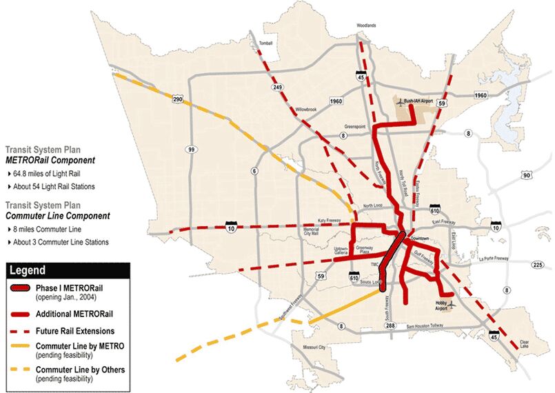
Authorization of Metro to issue bonds, notes and other obligations payable, in whole or in part, from 75% of Metro's sales and use tax revenues in an aggregate principal amount not to exceed $640,000,000 for Metro's transit authority system, including the Metro Solutions transit system plan (as described in Exhibits A and A-1 of Metro Resolution No. 2003-77 and the official notice of election, which are incorporated herein), which includes bus service expansions (including new buses, bus routes, transit centers, and Park & Ride facilities) and construction of extensions and new segments of Metro's rail system known as "MetroRail," approval of such plan and construction of all segments of the MetroRail and commuter line components (including approximately 64.8 miles of light rail and 8 miles of commuter line, as described in Exhibits A and A-3 through A-9 of such resolution and the official notice of election, which are specifically incorporated herein and generally summarized below), and dedication of 25% of Metro's sales and use tax revenues through September 30, 2014, to street improvements and related projects as authorized by law, and with no increase in the current rate of Metro's sales tax.
* * * * * * *
The following summary lists the components and segments of MetroRail and commuter line, as described in Exhibits A and A-3 through A-9 of such resolution and the official notice of the election, and is a part of the ballot and the proposition being submitted to the voters at the election. The segments marked ** are expected to be completed by the end of 2012 utilizing the proceeds of the $640 million of bonds, if approved at the election.
1. NORTH HARDY
**A. UH-Downtown to Northline Mall
B. Northline Mall to Greenspoint
C. Greenspoint to Bush IAH Airport
2. SOUTHEAST
**A. Downtown/Bagby to Dowling
**B. Dowling to Griggs/610
C. Griggs/610 to Park & Ride in the vicinity of Hobby Airport
D. Sunnyside: Southeast Transit Center to Bellfort
E. Sunnyside: Bellfort to Airport Blvd.
3. HARRISBURG
**A. Dowling to Magnolia Transit Center
B. Magnolia Transit Center to Gulfgate Center
C. Gulfgate Center to Telephone Road
4. WESTPARK
**Wheeler Station to Hillcroft Transit Center
5. UPTOWN/WEST LOOP
Westpark to the Northwest Transit Center
6. INNER KATY
Downtown/Bagby to Northwest Transit Center
7. SOUTHWEST COMMUTER LINE
Fannin South Park & Ride to Harris County line
########################################
A. Northline Mall is more than a mile from Hardy Road and the N. Hardy Tollroad.
B. UH-Downtown is 2/3rd's of a mile from Hardy Street and 1/2 mile from the closest point of the planned N. Hardy Tollroad southern extension.
C. Greenspoint (both the namesake mall and the center of the general district) is more than a mile from Hardy road and the N. Hardy Tollroad.
D. All of Bush IAH Airport is more than a mile from Hardy road and the N. Hardy Tollroad.
E. Gulgate Center is more than a mile from Harrisburg Blvd.
F. Wheeler Station is 2 miles east of Westpark road, 4.25 miles from the Westpark Tollroad.
Thus it is quite clear that Metro and the ballot language were about general corridors, with those corridors extending beyond any namesake and being defined as at least a mile either side of the centerline of its namesake (since Northline Mall is more than a mile from the centerline of the N. Hardy Tollroad, which parallels and continues past it.) Since Richmond is within 1/4 to 1/2 mile of any road or rail ROW being claimed as the namesake, clearly its use is not precluded based on any ballot language.
-
Call me a pessimist, but I've just about lost all hope for rail on Richmond. Can anyone come up with a viable alternative (as supposed to running it through a dead zone like 59 or Westpark)?
The abandoned SP railroad ROW that partially paralleled by Westpark is inferior, but 59 doesn't have to be a transit dead zone. Transit routes down the middle of a freeway usually are pretty inferior at creating TOD's, in large part because of the unappealing long walk across a usually open and noisy ped bridge. However unlike lines that run down a fwy, my suggestion in the prior post would have 2 stations cross the SW Fwy at sharp angles. That mitigates some of the problems because the station ends are now beyond the freeway and one just descends shorter (climate-controlled) ramps and stairs on the desired side of the street at the foot of the development. Much less a sense of traversing a vast wasteland. Most of the complexes on the north side of the fwy are very ped friendly or with high redevelopment potential, but there are a heck of a lot of jobs and some multi-family within 1/4-1/2 mile. But on the south side there is a lot of potential for some pretty good-sized redevelopment, could see projects similar to what is going up along the east side of 610 in the Galleria area or as it moves up from Rice Village. And keep in perspective the fact that the area of Richmond in question doesn't have near the TOD potential that the Main Street line had.
Don't analyze this as a stand-alone line, but as part of a much wider comprehensive system. Is this section of the line's primary purpose to generate riders all along the way, or deliver riders from elsewhere and other lines/modes to the big employers along it? West of 610 and east of Main will probably produce most of the line's originating traffic, but in between the employment centers are probably more important.
-
I've looked at this some more, and am convinced that regardless of Culberson's original intent, this is a tremendous opportunity IF Metro takes advantage of it (of course it can also easily end up being a disaster.) The key to making this work is smart design (duh) and extracting a tradeoff from Culbertson in return. More about that at the end, let's examine this by section, but the exec. summary is that an option via the SW Fwy west to Kirby then elevated on the north side of it to at least Edloe may be pretty close in cost to the current proposal via Richmond.
As I noted in an earlier post, east of Kirby using the freeway ROW isn't insurmountable, as long as they don't get stuck on having it on one side or the other, We are talking about bridging less than a 200' width. There is a shelf on the south side (where the power lines are) wide enough to accomodate 2 tracks east to at least Mandell and probably past Graustark. This south shelf extends east of Montrose, though I don't know how wide.
Check it out here:
http://www.houstonfreeways.com/modern/2005...ton_update.aspx
http://www.houstonfreeways.com/modern/2005-08-13_us59.aspx
http://www.houstonfreeways.com/modern/2005...ton_update.aspx
It may not be wide enough for two tracks all the way to Montrose, but there also appears to be a narrow shelf on the north side, at least in places, so perhaps the tracks could split with one running on each side from east of Mandell to Montrose. And there is also the option of building on the shelf and cantilevering out just a bit if extra room is needed.
The point being that there isn't any need for a long and costly elevated stretch over the SW Fwy between Kirby and the Main St. line, just a bridge (or perhaps too if split into 2 separate tracks.) Since the reconstruction required for placing tracks in the street make it pretty costly ($30+ million per mile) using this shelf should be comparable in cost to routing via Richmond between Main and Kirby. And as I noted in an earlier post, the amount of density and redevelopment potential bypassed in that stretch is pretty small.
So head west from Main on Richmond, turning south on Montrose and then turn southwest to bridge the fwy and head west on the shelf to Kirby. While Montrose appears to be as wide sidewalk to sidewalk as Richmond, the intersection of them might be a traffic problem for turning the corner and Metro's half-assed compromise to conserve street width of only having two widely-spaced single-direction platforms isn't ideal, either. So perhaps going west it should elevate to go around the corner before descending, which would allow for a single tight station near the intersection (and closer to U. St. Thomas), though that will drive up costs. But either way Richmond to Montrose can work, and Culberson already said that he's ok with using this small segment of Richmond.
What will make or break this line is how well it accesses Greenway Plaza and the adjacent areas. A route along the south side of the fwy through here just won't cut it. (Along the abandoned SP railroad ROW that some incorrectly call Westpark, which is actually a parallel road that has never been been proposed to have light-rail on it, so much for the BS lie about voting for rail on Westpark.) As I noted earlier, turning north on Kirby and routing along Richmond west to the UP railroad tracks before turning south back to the abandoned SP ROW would work, and combined with the south fwy shelf route east of Kirby produce the same ridership (or probably slightly more account of adding in 1/4 or 1/2 mile density and redevelopment potential around the south side fwy/Kirby intersection) and virtually the same timing account of faster non-street running. So that option would work.
But the split station designs and their resulting multi-block walk for virtually every rider regardless of destination isn't ideal, nor is some of their placements, and the street-running is slower and interferes with traffic more than a shorter elevated line along the north side of the fwy west of Kirby would. Elevation here is going to add big time to the cost, and in some places there appears to be no other option than to build above or below the feeder road. But the distance needed to be elevated here is only about 1 to 1.5 miles (depending on where to cross back over to the south side of the fwy and the abandoned SP rail ROW) and the station placement and design could be vastly better than the current proposal. Access to Greenway Plaza's climate-controlled pedestrian passageways would be better and most riders wouldn't have to fight crossing the streets as compared to the Richmond center median stations (both of which should result in higher ridership.) You'd lose some of the riders from the density north of Richmond towards Alabama, but gain much of that back from areas south of the fwy (IF station location, design, and pedestrian bridges are done correctly) and there appears to be more redevelopment potential.
Here's my proposal: Westbound approaching Kirby elevate from the abandoned rail ROW and turn north crossing the fwy at Kirby with a station that bridges the freeway. This would allow for pedestrian access to all 4 corners without having to cross the street. Would need to be enclosed to mitigate the freeway noise, but would be air conditioned (as would the enclosed pedestrian connections, which extends the distance riders would be willing to walk to/from the station.) Encloser would require electrification or special ventilation, but with current diesel prices electrification might be more justifiable again. Stations bridging freeways aren't unique, MARTA has one in downtown Atlanta.
Stay elevated to a Greenway Plaza station on the east side of Edloe. Might be possible to duck down to ground-level after Buffalo Speedway to Cummins, but the savings might not be worth the extra traffic hassles of crossing in the tight confines along this strip and under Edloe. Probably best to stay elevated, and add a pedestrian bridge from the GP Station to the south side of the fwy. Then cross 59 at Weslayan with another enclosed station straddling the freeway and pedestrian connections to the 4-corners. All that adds a lot of cost, but it also simplifies the bridging of the railroad tracks with a cheaper arrangement.
An option to reduce the cost would be to have the Greenway Plaza station bridge the freeway east of Edloe and onto the abandoned SP ROW west of there. That would reduce the distance needed to be elevated from about 7000' to about 5000', but a south side Weslayan station would be slightly more than 1/4 mile walk from the hospital and anything on Richmond, and would still really need a ped bridge across the freeway. However Greenway Plaza and serving both sides of the freeway at Kirby are the meat of this corridor, so this might be an acceptable compromise if the proposal is on the bubble for FTA recommendation.
Cost is the huge issue, but one way to reduce its impact and get this corridor built right would be to go to Culberson and propose that as a tradeoff for moving away from a viable and cheaper Richmond alignment he commit to securing the funding difference from fed or state sources. Fed would require a specific earmark, though the state might be a good option to pursue. Let's see some of that power in action, is he actually seeking a reasonable solution? (To all, please spare us anymore spamming of anti-Culberson rants, we have read plenty, it is time to end the temper tantrums and talk about how we can get this built. Save it for after this is finally decided one way or another.)
Metro still has to be concerned about meeting the FTA's somewhat tough cost per rider standards, so let's look at costs. Very rough industry rule of thumbs for light-rail are $30-50 million per mile for at-grade/street running, $100 mil. per mile for elevated, and $200 mil. per mile for subway. This is a very rough average allocated total costs including land, stations, construction, etc. The Main St. line was about $50 million per mile, and almost entirely street running, so I'll use that for Richmond, but subtract out for electrification, roughly about $4 million per mile. Going west, from Montrose to the UP RR tracks is 3 miles, so 3 x $46 = $138 million. It is about 1800' along the RR tracks from Richmond to the abandoned SP ROW, but not in-street, so at roughly $10 million per mile (average allocated cost of double-track commuter rail on undeveloped ground) add another $3 for a total of $141 million via Richmond. If electrified, add 3 miles x $4 mil. = $12 million, for a total of $153 million.
For the other two options, going down Montrose (assume street running) is about 1000' x $50 mil per mile so about $10 mil. Need to bridge the freeway at an angle, so about 200' at $100 million = roughly $4 million. Along the south shelf of the freeway and the abandoned SP ROW to Kirby is about 7000', so 1.3 x $10 = $13 mil. Now assume that we have to shift the power poles east of Mandel. Moving high-power lines is roughly $1 mil per mile, but less than a half mile, so will round up and add $1 mil. Kirby to Weslayan elevated on the north side and back across is about 7200', so 1.4 x roughly $100 mil. per mile is $140 mil. Another 1700' on the abandoned SP ROW gets us to the UP railroad tracks, so .3 x $10 mil. = $3 mil. Total so far is $160 million, vs. $141 via Richmond. But the 2 enclosed stations over the freeway and their pedestrian connections would probably add a bit more to the costs. How much I have no idea, so how about costing them as if the stations were built elevated but next to rather than straddling the fwy (which would already be costed in the $100 mil. per mile average) and cost out separate connecting ped bridges instead. Roughly 350 feet each, but to hit all 4 corners let's say 600' total per set, and use that for Greenway Plaza's, too. I've seen estimates from $.5 to $1 mil per 100', so let's go on the high-end (gotta have a semi-World-Class City piece of art, donchaknow) and say $6 mil. each. Total cost of roughly $189 for this segment vs. $141 via Richmond.
Or how about the shorter elevated option, crossing back at Edloe. 2200' fewer elevated @$100 mil. per mile drops the cost by $40 mil, then 2000' on undeveloped abandoned railroad ROW @ $10 per mile adds to the cost $4, for a net total of $153 million. Roughly comparable to via Richmond.
Doublecheck the math: 1000' on Montrose = $10 million, bridge over fwy is $4, 7000' on south side of fwy to Kirby is $13, utility pole shift is $1, 5000' elevated on north side to Edloe is $100, 2000'+1700' of abandoned SP ROW is $4 + $3, plus a package of pedestrian bridges at each of 3 stations =$18. Total = $153.
So Montrose to the UP railroad tracks at the SP RR ROW via Richmond is approx. $141 million ($153 if electrified.) Via the SW Fwy and then elevated on the north side from Kirby to Edloe is roughly $153 million, and if the elevation continues to Weslayan it goes up to around $189 million. These latter two options are also several minutes faster, as there is only 1000' of slower street running instead of 3 miles of it.
Are my cost estimates off? Surely, perhaps quite a lot, but OTOH they do suggest that if Metro wants to come up with a good solution using Culberson's current restrictions, they can almost certainly do so without breaking the bank. Also that these options would be close enough in costs so as to not threaten fed funding. It would only require 1 mile of elevation, and there are potential cost savings east of Kirby and west of Edloe to mitigate some of that. The key is to be on the best side of the freeway in the heart of the area with the vast majority of the ridership potential. Stations that straddle the freeway would maximize that, and air-conditioned ped walkways that allowed bridging of intersections would extend the distance riders are willing to walk. So we get a better and faster system design if Metro gets an agreement from Culberson to find funding for the difference.
-
The first bridge after Montrose is Graustark so you may need to take a few homes there before you get to Mandell.
Darn it, I was looking at an aerial that was pre-59 reconstruction east of Mandell! But there are multiple ways to deal with a Graustark bridge:
1) Replace it with a compatable design.
2) Simply eliminate it as a through street.
3) On the northwest corner is a multifamily building, and in the northeast corner there appears to be about 90' between the freeway (overhead at the time) and the first building. 59 runs at a slight diagonal to the grid, creating leftover odd lot sections. Now if the new section of freeway here isn't any wider than it is at Mandell, there should be plenty of room to squeeze by on the north side of the bridge if they buy out that one multifamily building. If it is apartments, nobody loses a home, they just have to relocate, and the owner is compensated for the loss of one building.
4) Buy the entire multifamily complex fronting the narrow Graustark and turn south from Richmond to 59 on it.
5) Do as Clusterbuck had suggested and turn south from Richmond at Mandell. This would require crossing and taking a small corner of a house's driveway at the northwest edge of the Howie Mandell Memorial Bridge. Put in full crossing gates in all directions and a whistle ban, and nobody loses a home.
6) Go with Clusterbuck's other suggestion and turn south from Richmond at Dunleavy. The northwest corner is Mike Dunleavy Park, which would only lose a tiny corner of edge grass.
6 (and to a slightly lesser extent 5) is less disruptive, but you lose some of the speed advantage of a longer run on dedicated ROW instead of in-street. But we aren't talking about a huge detour, the extra length of crossing down and then back up at Kirby is less than 1/2 mile total. No more than 1.5 minutes added (at 20 mph average), and the higher speed in the southern section should reduce that to near zero.
I think you put a lot of thought into this plan but with federal dollars scarce, each city has to fight to get them by showing the feds the most efficient plan possible. Bridges and turns and cantilevers over the freeway and the possible destruction and rebuilding of some of the new 59 bridges will signal to the Feds we really aren't serious in our efforts. I truly believe that this is Culberson's goal: to make sure a plan is submitted that assures failure.Elevated is more expensive, but street running ain't cheap, especially in this narrow section of Richmond. Probably around $30 million per mile here, so the cost differential may not be as great as some are thinking. On the other hand converting the abandoned rail ROW could be a lot cheaper than street running because you often can avoid digging and moving underground utilites and street replacement, instead just laying ballast and track on top. Turning south at Montrose requires almost 1/2 mile of elevated. Rough estimates at $100 million/mile for elevated adds $50 million to cost. Add 4500' of converting the abandoned rail line at approx. $6 million/mile, minus 4500' net less street running (eliminated Richmond but add Kirby and Montrose portion) at approx $30 million per mile comes to roughly $30 million in higher cost (50+5-25), plus the cost of dealing with the Graustark bridge and design complexities with this specific elevation. Same number of stations, similar number of cross streets/intersections. So rough estimate about $40-100 million more but with higher ridership, too.
Similar calculations can be done for the other options.
The key numbers to the feds isn't overall cost (though still important), but cost per rider and cost per new rider. Complicated design isn't a problem for funding if it can rationally be justified.
-
EDITED: (Because I misread a couple of items related to Clusterbuck's and Culberson's proposals.)
The Clusterbuck Plan and Culberson's proposal could actually produce an even better result, if altered sufficiently. If Metro routed it west on Richmond to Montrose (directly serving U. St. Thomas) and then south to the freeway, they'd only have to elevate it for slightly less than a half mile, between Montrose and the 1st bridge at Mandell. At Mandell there is enough of a shelf on the south side between the freeway/end of the upper bridge structure and the backyard walls. Technically the light-rail ROW can narrow to pass through a 20' ground choke point (slightly wider needed for the wire support poles) and it appears to be close to 30' at Mandell and widening to the west along the abandoned railroad ROW. So what is needed in this section is for the rail to be elevated over the freeway, but doesn't have to get higher than ground-level, and thus shielded from affecting adjacent homes by sound walls. Several possible ways to elevate this section:
1) Bridging to a single line of center poles in the median, if enough room can be found.
2) Bridging via a series of plank supports across half of the freeway for much of the way from each direction, which would require narrower center support poles. Uglier, but could be creatively decorated with sufficient will, budget, and the right artist.
3) Bridging via a series of plank supports across the entire freeway that wouldn't require any center supports. Similar opportunities for industrial artistry.
All expensive, but no apparent reasons why any homes need to be taken.
Now let's look at how we could adapt Clutterbuck & Culberson's freeway option to produce a better solution than any now proposed. The largest complexes along Richmond west to almost Kirby are within about a 1/4 mile of Montrose/Richmond. Some north of Alabama west of Shepherd, but that's more than a 1/4 mile north of Richmond to get to the edge of that. So not much ridership missed by skipping this section, though perhaps passing on some future redevelopment potential. In contrast there are apartments and employment along the abandoned railroad ROW (south side of the freeway) from Shepherd west to Kirby, and within a 1/4-1/2 mile of the latter intersection. Also might make for a nice transfer to a future Kirby/Rice Village shuttle or even trolley. In fact ridership (and redevelopment potential) is likely to be higher, with good station placement.
The key to this route is to then cross back north to hit the heavy employment on that side of the freeway. Head north to Richmond via Kirby, with another stop at that intersection. Since this south side alignment would be in exclusive ROW from Kirby-Montrose instead of street running and hitting lights on Richmond (regardless of theoretical signal pre-emption), the extra distance shouldn't result in any longer running times than Richmond. Going aerial down the freeway from Montrose to Mandell will add a huge expense (though the ROW west of Mandell will be cheaper than using Richmond), so they probably can't afford to lose the big chunk of Greenway Plaza/Richmond ridership that a pure south side line would result in. Trying to mitigate with long pedestrian skybridges over the freeway is going to drive up costs and be less effective than actually penetrating this district.
So head up Kirby to Richmond, lots more ridership potential here. But it requires 2 stops, Richmond/Kirby and one on the south side of 59 between Greenbriar and Kirby. Crossing under the freeway is just a huge psych disincentive for pedestrians, and with just a single station serving Kirby-Shepherd for both sides it is just too far for many people to walk, regardless of placement. Yeah, it may add another minute to the ride for the extra station, but this is where Metro is falling down in trying to make light-rail be all things to all people. You can't adequately serve spread out semi-dense housing/employment and also provide speedy long-distance commutes. Let the HOV buses and perhaps commuter rail handle the long/fast trips, and use LRT/trolleys to adequately distribute them and serve neighborhoods/districts.
Now that we are back on Richmond going west from Kirby, the same arguments/merits/disadvantages for the options west of Greenway Plaza are in play, though cost factors are probably more critical. My point is simply that this is an opportunity that could produce a better solution than the current ones being considered (and save lots of hassles and hardship along some portions of Richmond) as long as the line travels Richmond from Kirby west past Greenway Plaza. That is the heart of the line and its potential, until the line (or at least some of its trains) is extended up Post Oak through the Galleria district.
Do I think Metro will take advantage of this opportunity and suggest what I just laid out? Doubtful. More likely they'll do what they've too often done in the past (like many other transit agencies) and stack the deck in their modelling to favor their preferred outcome. But maybe not, maybe they really have changed. How they handle this could be quite revealing, either positively or negatively.
The more I've looked into this, the more I'm in favor of using Richmond through Greenway Plaza, but diverting south of 59 east from Kirby to Montrose. I urge you guys to carefully look over the aerial photos at HGAC's website.
-
Somewhat flawed? no it was a BAIT & SWITCH IMO. Not an outright lie, but certainly a deception on METRO's part. I am still waiting for anyone to define exactly what the Northern and Southern boundaries are on the "Westpark Corridor". It should be fairly simple. I was on Bellaire today inside the loop and it is also 6 lanes wide, and goes right to the TMC, seems like it might be a good alternative route up to Rice, then turn North to Westpark and on to Hillcroft - perfect.
We have enough lawyers in the neighborhood that we get our legal services free.
Ya know, I have no problem with someone raising honestly felt concerns such as about how rail will affect traffic, property values, noise, etc., but this whole "They said Westpark" argument is such a transparent red herring tactic. It is quite evident now that you, like the most annoying NIMBY's, will throw out any BS just for argument's sake, just like a used-car salesman or sleazy lawyer.
You want Clintonesque-style parsing of the meaning of "Westpark"? Fine, here we go:
1. There is no Westpark road for 2 miles from east of Kirby to Midtown (vicinity of "Wheeler Station",) so even under your definition of the ballot language Metro is free to use any street or path it chooses in that section. The map accompanying the Metro Solutions proposal that was voted on showed a route going from west of 610 to across the existing light-rail line at Midtown and east towards the university.
http://www.lightrailnow.org/images/hou-met...ns-rail-map.jpg
So it was clear that a rail line was proposed for the section east of where Westpark ends at Kirby, which also makes it clear that Metro was proposing using more than just the road named Westpark in this corridor. Thus your argument is fallacious. But let's go further:
2. Neither your group nor Culberson have ever actually advocated placing the rail line on Westpark road. Instead you have advocated using the abandoned railroad ROW, formerly owned by the Southern Pacific railroad, and parts of the US 59 ROW near Midtown. None of that railroad line was ever named Westpark, only the parallel road. So if we want to use your strict definition of "Westpark", you are also engaging in bait-and-switch tactic.
3. If you want to change your argument and widen the definition of "Westpark" to say that it is included in the Westpark Tollroad corridor that was built on part of the railroad ROW (with part of it reserved for rapid transit), fine, but the Westpark Tollroad's east end is at 610. Using this definition still allows Metro to pursue other options east of there.
4. If you want to change your argument to widen the definition of "Westpark" even further to include the former railroad ROW east of 610 since it is parallel to Westpark road, then how wide does one go? What precedent can you cite to establish the limits when defining the width of a general transportation study corridor? I'll give some. TXDOT uses a 10-mile width for some of its initial corridor planning, then narrows it down to 1-mile. The centerline of the Hardy Tollroad deviates from the centerline of Hardy Road by more than 1800' in Spring and Westfield, more than 2000' north of Beltway 8, and by approx. 1000' in the planned southern extension. So we have several precedents where a transportation project included in its ROW land extending out 1800'-2500' feet from the centerline of the corridor's namesake. East of 610 all of Richmond is within 2000' of the centerline of Westpark, most within 1800'. All of Richmond is within 2100' of the centerline of the abandoned railroad ROW, most within 1900'. Also note the vagueness of the line on the Metro Solutions map, illustrating that Metro wan't advocating a specific street, but rather a general corridor.
5. Ballot language itself:
########################################
Authorization of Metro to issue bonds, notes and other obligations payable, in whole or in part, from 75% of Metro's sales and use tax revenues in an aggregate principal amount not to exceed $640,000,000 for Metro's transit authority system, including the Metro Solutions transit system plan (as described in Exhibits A and A-1 of Metro Resolution No. 2003-77 and the official notice of election, which are incorporated herein), which includes bus service expansions (including new buses, bus routes, transit centers, and Park & Ride facilities) and construction of extensions and new segments of Metro's rail system known as "MetroRail," approval of such plan and construction of all segments of the MetroRail and commuter line components (including approximately 64.8 miles of light rail and 8 miles of commuter line, as described in Exhibits A and A-3 through A-9 of such resolution and the official notice of election, which are specifically incorporated herein and generally summarized below), and dedication of 25% of Metro's sales and use tax revenues through September 30, 2014, to street improvements and related projects as authorized by law, and with no increase in the current rate of Metro's sales tax.
* * * * * * *
The following summary lists the components and segments of MetroRail and commuter line, as described in Exhibits A and A-3 through A-9 of such resolution and the official notice of the election, and is a part of the ballot and the proposition being submitted to the voters at the election. The segments marked ** are expected to be completed by the end of 2012 utilizing the proceeds of the $640 million of bonds, if approved at the election.
1. NORTH HARDY
**A. UH-Downtown to Northline Mall
B. Northline Mall to Greenspoint
C. Greenspoint to Bush IAH Airport
2. SOUTHEAST
**A. Downtown/Bagby to Dowling
**B. Dowling to Griggs/610
C. Griggs/610 to Park & Ride in the vicinity of Hobby Airport
D. Sunnyside: Southeast Transit Center to Bellfort
E. Sunnyside: Bellfort to Airport Blvd.
3. HARRISBURG
**A. Dowling to Magnolia Transit Center
B. Magnolia Transit Center to Gulfgate Center
C. Gulfgate Center to Telephone Road
4. WESTPARK
**Wheeler Station to Hillcroft Transit Center
5. UPTOWN/WEST LOOP
Westpark to the Northwest Transit Center
6. INNER KATY
Downtown/Bagby to Northwest Transit Center
7. SOUTHWEST COMMUTER LINE
Fannin South Park & Ride to Harris County line
########################################
A. Northline Mall is more than a mile from Hardy Road and the N. Hardy Tollroad.
B. UH-Downtown is 2/3rd's of a mile from Hardy Street and 1/2 mile from the closest point of the planned N. Hardy Tollroad southern extension.
C. Greenspoint (both the namesake mall and the center of the general district) is more than a mile from Hardy road and the N. Hardy Tollroad.
D. All of Bush IAH Airport is more than a mile from Hardy road and the N. Hardy Tollroad.
E. Gulgate Center is more than a mile from Harrisburg Blvd.
F. Wheeler Station is 2 miles east of Westpark road, 4.25 miles from the Westpark Tollroad.
Thus it is quite clear that Metro and the ballot language were about general corridors, with those corridors extending beyond any namesake and being defined as at least a mile either side of the centerline of its namesake (since Northline Mall is more than a mile from the centerline of the N. Hardy Tollroad, which parallels and continues past it.) Since Richmond is within 1/4 to 1/2 mile of any road or rail ROW being claimed as the namesake, clearly its use is not precluded based on any ballot language.
-
I work with many foreigners on a monthly basis from all over the world. Russia, Japan and Italy are the big three. I've taken groups of Russians and Italians to the Museum District to boast about our town. The Russians really enjoy the Menil everytime they come. The Russians I know have ridden the light rail because I rode with them. They were not at all impressed. To them, our line was a joke because I couldn't give them an EXACT time of when the train was arriving!
Yeah, "Every 6 minutes" is such a difficult concept to grasp...
-
Rep. Culberson alone can't kill this line, he can only attempt to restrict federal funding. As long as Sen. Hutchison's office is kept aware of the situation, it is almost certain that nothing of the sort will make it out of the Senate. She always been pro-transit, at least for wise proposals. Plus there is also the possibility of the Democrats taking control of the House in January. And of course Metro has once before built a rail line without fed funding. Would be difficult, force a reprioritization and delays, but all that is certainly possible. For starters that could postpone construction of their ill-placed joke of a "Grand Central Intermodal Bus Stop With a Pseudo-Iconic Plaza."
If anything, Culberson just made it more likely that the Afton Oaks alignment will be chosen. It has been obvious for awhile that the only viable and sensible options required using at least part of Richmond. By avoiding total rejection, he and AO were in a position to at least bargain and win concessions. But with Culberson now declaring against any Richmond use, why would Metro need to appease and work with him anymore?
This pretty much seals the deal. In one week Metro will chose either Richmond to the UP or Richmond all the way to Rice, and the deciding factors now will be in regards to overall cost and alignment/terminal issues west of 610. Metro is now free to go with the best new rider/cost option. Since Richmond to Rice via AO is probably the most simple and cheapest option, I'd wager that this will now be chosen.
With today's announcement the anti-Richmond group may think that they've just crossed the Rubicon, but it actually appears that they've fired on Ft. Sumter.
-
What makes you think we haven't already had an arborist out and gotten an assessment? Give us a little credit.
Then what exactly was the arborist's assessment?
-
the problem with trenching the rail along that particular route is that it will have to be done from memorial all the way past bellaire
No it wouldn't. Buffalo Bayou makes that impractical, it would have to come up and go back down to cross it. All that is needed is San Felipe through the 59 frontage roads, the rest was just an idea thrown out by someone pandering to IMBY me-too-ism and the Mothers for Memorial Park utopians.
and there wouldn't be enough room to put in a proper drainage system AND to keep that line running during construction. That in addition to how Richmond ponds during some of the heavier downpours it would be inevitable that flooding would shut down that particular line.While this would only be a minor disruption if it happend for a few hours, on some of our wetter months that could be a potential of days and that would be incredibly chaotic to the ENTIRE rail system for this region due to the fact that this particular is already busting at the seams with railtraffic to the point where any disruption would almost be a major economic calamity for not only the railroads, but the clients that depend on them heavily.
Actually the rail and parallel electric utility corridor is more than 200' wide, and even discounting the parking lots around Westheimer (which can have drainage tunnels placed beneath them) the remaining ROW is 120' wide. Anything can be engineered, it is just a matter of cost. The UP railroad already has a multi-mile trench recently built in Los Angeles (where contrary to lyrics it does flash flood occassionally), and this one can be designed with pumps to handle pretty much any storm. The I-10, I-45, and 59 trenches are far bigger catch basins. How do you think they were going to design the (wider) proposed tollway in this corridor? It would have tunneled under Memorial Park and Buf Bayou, but only been trenched south of there to at least 59.
BTW, notwithstanding any public statements, the plans for adding a tollway (either in the utility easement or eventually rerouting the UP railroad) in that corridor are far from dead. Shelved for now, but watch how the bridge design over the UP (regardless of route) leaves room for a 6-lane tollway to pass beneath. Almost seems like there is an unspoken agreement to trade transit rail now for the tollway later.
If they won't let the West Loop be double-decked, what's the alternative other than a lowered tollway in the utility/rail corridor?
-
AESTHITICS - BINGO! I do not believe for even a nano second that the trees along the esplenade will survive the construction - spare me what metro says.
Well I'm certainly not a Metro apologist, as my posting history shows (defense of Tom DeLay's standing up to the old corrupt lying Metro back when they were run by a gal with a fraudulent resume, and a skepticism going back to Tootsie's monorail), but I can give you a viewpoint from someone who used to do landscaping and studied horticulture. Yes, construction carries a risk that some will die, but some or all could survive, too. There are plenty of examples around Texas of where streets were widened and the existing medians with trees were narrowed and many of the trees surviving. It just depends on each tree and how careful the crews are. I assume these are Live Oaks? That's a pretty tough species, one reason it is so overused for street plantings.
One danger is from soil compaction, which crushes the tiny pockets in the soil and makes it harder for the roots to 'breathe'. Most of the tree deaths on construction sites are the result of the heavy equipment packing down the soil over the roots, which is why a good contractor will put up temporary fencing around each tree to prevent this. So Metro can take measures to prevent compaction, though it would be very wise to have volunteers keep an eye on them during the process to make sure. But luckily Live Oaks are more tolerant of soil compaction than most trees.
Another problem is that the surface area where the shallow roots take in nutrients will (obviously) be reduced as the median is narrowed. So it will depend on how well each tree adapts to that change, but Live Oaks usually put down plenty of deep roots and are less dependent on their shallow ones. You might recall how small an open area street trees in downtown and dense nieghborhoods have beneath their grates (with paving and buildings everywhere else around them.) The AO trees in the narrowed medians will still have much more surface area than those trees, but again it depends on how well these mature trees adapt. Not sure how deep Metro's rail construction will go and if there are any special techniques they can use to reduce disturbance of the highest roots, but I'd say the odds are good that most or all of the trees will survive.
And we are talking about less than a dozen mature trees, yes? I looked at recent aerial photos and those from 1995, and this is what I see:
The trees are along a 1/4 mile strip of 2 main and 2 lesser medians. The 2 main medians (middle) each have 5 trees, with there is 1 on a lesser median to the east, and 3 trees with much smaller canopies on the lesser median to the west, and maybe a 4th tree that is a new planting without much of a canopy yet? In the 1995 photo those western 3 seem to cast short, thin shadows, perhaps being newly planted then. Also looks like 1 of the 4 in the 1995 photo didn't survive to the 2004 photo.
So at worst the neighborhood would lose 11 mature trees and 3 younger ones, but more likely all but perhaps one or two would survive.
Why not get an arborist out there to do an assessment? If the plan really does threaten the trees, this would bolster your argument and undercut Metro's credibility when they claim most or all of them can be saved. And if he/she finds that most or all should survive, then you won't have to worry about that aspect.
-
Hey Afton Ag, why exactly would property values go down for the Afton Oaks neighborhood if light-rail runs through there on Richmond? Without a station stop the effect on values should be minimal (whether positive or negative), though perhaps with a slight premium for being within easy driving distance of a nearby station.
Risk of LRT raising crime rates? Since there isn't going to be a station, the opportunity for criminals to ride in isn't a possibility, so we can rule that argument out.
Train noise? How is light-rail any noiser than the diesel buses (and cars and trucks) that already run down Richmond? In fact once the line is electrified the LRT vehicles will be noticeably quieter than buses. If the line ends up going through AO on Richmond, maybe it would be wise to push for electrification from startup as a reasonable and achievable compromise. That is what far north Dallas residents did (and won as a concession) in their compromise, a more wealthy and political powerful neighborhood than AO that had to settle for a transit rail line through it.
Horn noise? A problem, but again, why not push METRO for concessions as part of a compromise? Have them do whatever it takes to eliminate horn blowing in the neighborhood, perhaps gates at intersections (which would also make it safer for all involved.)
Aesthetics? Again a potential problem, but one that only affects those residences actually fronting Richmond. Those are just a small percentage of the entire neighborhood, no logical reason why it would affect values anywhere else but on Richmond itself. And since those Richmond houses already front a busy 6-lane arterial hosting buses and trucks, their value has already been reduced by that. Why would adding light-rail trains while reducing buses make any difference, especially if the louder buses are reduced more than trains are added (since trains have much higher capacity)?
That being said, while I could live with an Richmond via AO alignment, I am strongly in favor of a route on Richmond west to the RR tracks and then south to Westpark. The Westpark area around 610 has a large number of jobs and dense housing, with potential for far more. Would be quite a waste to avoid all that just to save 1-3 minutes, as long as at least half the service turns north and goes up Post Oak to serve the Galleria area (always hated that artificial 'Uptown' new-marketing-gimmick-of-the-week-because-we-must-be-a-WORLD-CLASS-CITY label.) Really would be best to turn south at the railroad tracks, and doing so would probably favor depressing the railroad tracks in a trench instead of a complicated road and LRT bridging. This would be preferable since car/LRT collisions are not nearly as deadly and destructive as car/freight train wrecks, which can cause derailments (and resulting hazmat releases. That area has already experienced their chlorine quota!) Plus the wait for a 1-2 mile freight train to clear is far longer than for a short LRT train. A freight rail trench would likely extend south of I-59's feeders and north past Westheimer and perhaps San Felipe, all of which currently can get snarled by waits for freight trains. So let's kill several birds with one stone.
A response to another poster somewhere back:
If today you plant a seed and water it, you'd be foolish to go outside tomorrow and be disappointed that a tree or flower hasn't yet sprung up. The argument that the Main Street Line hasn't produced development reminds me of the same arguments made against Dallas' light rail almost a decade ago. There is usually a time lag for the development, for a variety of reasons. But now that new projects and redevelopment has risen up in Plano, Richardson, and north Dallas along the original line (and with even more in the planning/approval process pipeline) many of the skeptical suburbs have switched their tune and have been pressuring DART to try and move up construction or add new lines to the long-range plan. Same with the American Airlines Center that was supposed to fuel dense redevelopment in the Victory area. Nothing happened for several years, but now all kinds of projects are springing up. Lots of construction cranes were in the TV pictures of the area during the NBA Finals.

METRORail Northwest Line?
in Transit
Posted
I didn't call you anything, but rather simply explained a process. The post wasn't about race, but how political urban myths are created. Wave the victim flag much?
And while local news is better than national, I wouldn't take at a face value anything political that a reporter says. Especially someone like Miya Shay, for example. DeLay's opposition to light rail was philosophical, he didn't think it was cost effective compared to bus. It was also because he didn't trust Metro, and rightly so, because they had been so dishonest and secretive about so much, beyond just fiscal matters. That was pre-Frank Wilson, when Metro was led by a woman with ethical issues, one of which would lead to her exit. But Delay did say that if the voters approved the 2003 vote (not certain about the year, but it was the one with the 'Westpark' term on the ballot) he would quit blocking funds. They did, he did. Relations were aided by Mayor White making changes at Metro and bringing somewhat of a new atmosphere where the agency was more forthright in its statments. Though some of that openness has slipped recently. Hopefully Brown, Parker, or Locke will do a similar housecleaning.