

FilioScotia
-
Posts
1,449 -
Joined
-
Last visited
-
Days Won
2
Content Type
Profiles
Forums
Events
Posts posted by FilioScotia
-
-
The old Corral drive-in next to the refinery was also just outside the Pasadena City Limits. That meant they served beer, and it was THE place to go if you could find a friend old enough to go with you and buy it for you. Countless Pasadena kids did that over the years. Me included.
Speaking of the Corral, I recently saw the Corral's big sign in an episode of American Pickers on the History Channel. Those two guys came down to Pasadena to rummage through Mickey Gilley's trove of old stuff looking for stuff to buy.
When they were done with Gilley, he sent them to another junk collector up near Dallas, and there on that guy's big lot was the Corral Drive-in sign. I mean the big vertical sign, with the letters running up and down, instead of side to side. It really does still exist.
-
Really. An old Warren Truss Bridge in Nacogdoches County will be moved to a public park in Nacogdoches.
Here's the story:
-
Yes that does appear to be the one. Thanks much. We can see a lot of the Meyerland/Westbury area, including the beginnings of Meyerland Plaza at the bottom, Westbury Square, and the outlines of the old Sam Houston Airport at the top.
Although, I think the top of the photo is a little bit more cropped at the top than the one I remember. i say that because in that photo we could see where Hiram Clarke crossed over Sims Bayou. That was of interest to me because four blocks east of Hiram Clarke and Sims Bayou on Simsbrooke Street I could make out the house where my first wife and i lived for a couple of years in the early 70s. That blew my mind.
I can't find that house in the photo you provided, but I like it anyway because it's a great look at how that part of Houston looked 50 years ago.
-
 1
1
-
-
Thanks to JR Gonzales at the Chronicle, here's one of the late great Sig Byrd's columns from 1954, with a few of his famously droll observations about life in Houston and other Texas places.
Sig Byrd was one of the great ones, and he was one of the last of that early and mid 19th century breed of newspapermen who really wore out the shoe leather talking to people and gathering stories.
-
Some time back, somebody here on HAIF posted a link to an eye-popping high altitude aerial photo of the entire Meyerland-Westbury area taken in 1960.
It showed the entire vast panorama of a part of southwest Houston just before it started getting overrun by residential and commercial developers.
Does anybody here have that link?
-
Ah yes. Trans-Texas Airways. TTA. Up here in east Texas we called it Tree-Top Airways.
When I was a kid growing up in Lufkin, I remember watching TTA's old DC-3 tail-draggers landing at the Angelina County Airport from my grandparents' house just down the road. It was nerve wracking to watch their takeoffs that barely cleared the trees at the end of the runway. They always made it, but we were never sure till we could see daylight between the plane and the trees.
-
removed by filioscotia
-
I'm fascinated by the photo of the "Birdsall House."
In his very fine and highly praised biography of Sam Houston, James L. Haley includes what looks like a tintype of a small house that's identical to it, with what appears to be a small lean-to shed nailed onto one side of it.
The picture is in the Texas State Library Archives, and the house is identified as the first executive mansion of the Republic of Texas.
It was in downtown Houston, somewhere in the general vicinity of what is now the Federal Building, and it was where Sam Houston lived in his first term as President, from 1837 to 1838, when Houston the city was the Republic's capitol, .
Here's a link to the book in Google Books.
http://books.google....houston&f=false
The photo of the first executive mansion is on page 192.
On page 191 there are details of the famous naturalist John James Audubon's visit to Houston -- the new City of Houston and President Sam Houston. Audubon later wrote about that visit, and his description of the President's executive mansion and its conditions is priceless:
"We approached the President's mansion wading in water above our ankles. The abode of President Houston is a small log house consisting of two rooms and a passage through, after the Southern fashion. The moment we stepped over the threshold (sic) on the right hand of the passage we found ourselves ushered into what in other countries would be called the antechamber. The [dirt} floor, however, was muddy and filthy; a large fire was burning, and a small table covered with paper and writing material was in the center; camp beds, trunks and different materials were strewed around the room. Here we were presented to Mr. Crawford, an agent of the British minister to Mexico, who has come on a secret mission. The president was engaged in an opposite room on some national business and we could not see him for some time."
Audubon wrote that when he finally got to meet with Houston, he was received cordially and Houston "offered us every facility in his power. He at once removed us from the anteroom to his private chamber, which by the way was not much cleaner than the former." Audubon wrote that Houston's cabinet was meeting in the bedroom, working, but they stopped to drink toasts to the republic.
Imagine. All that was going on in at the same time in that tiny Birdsall house.
-
Thanks for that info. I love learning things like this about the history of our area.
-
Can't find any photos, but here's what the Texas State Historical Ass'n website says about the SA & AP railroad, and the depot in Clodine, a town that no longer exists, but was in the area now generally known as Mission Bend..
"Clodine is twelve miles northeast of Richmond and twenty-one miles southwest of Houston in Fort Bend County. The town was established around 1888 as a station on the San Antonio and Aransas Pass Railway and was possibly named by a railroad official for Clodine King of Houston.
The settlement acquired a post office in 1893 and by 1896 had a general store, a Baptist church, and a population of fifty. In 1897 Clodine had a community school. By 1914 its population had dwindled to twenty-five, but by then residents had telegraph and telephone connections. In 1925 the population was reported as ten and in 1929 as seventy.
The Texas and New Orleans Railroad bought the San Antonio and Aransas Pass line in 1934 and subsequently removed the depot and section houses at Clodine."
As for the Gulf, Colorado and Santa Fe RR, I am almost 100 percent sure it never had a depot in Houston, inasmuch as it was built in the mid 1800s with the specific goal of NOT passing through Houston.
It was in trouble practically from start. Here's the short history of how the GC & SF RR was bought up by the Atchison, Topeka, Santa Fe..
"The Financially-troubled Gulf, Colorado & Santa Fe Railway Company, a Texas line with nearly 700 miles of track in service, provided just such an opportunity. The GC&SF was required, as part of a merger agreement, to construct a 171-mile line from Fort Worth to Purcell, in the Indian Territory, where AT&SF had a railhead.
The connection was completed, and the merger became official on April 27, 1887. GC&SF continued to operate as a wholly owned subsidiary until finally merged directly into ATSF in 1965, by which time it had about 1,800 miles of track in service."
The GC & SF had a large Galveston depot, which is still standing today, and is now the home of the Galveston Railroad Museum.
-
As a longtime, but now former, Houston resident, I also want to thank Tana for putting up such a great website about Houston's history. Her photos really take me back to a time when Houston was a great and fun place to live and work.
Tana: Your website looks very professional, and I think you could create websites for a living, if you're not already doing that.
Those old shots of the Gulf Freeway reminded me of a wonderful E-Book a Houston writer did a few years ago on the history of Houston's Freeways.
It's a well written and very informative story with a multitude of fascinating photos of the city before, during and after the freeway system was constructed. If for no other reason, it's worth checking out just for the photos, because most of us have probably never seen them before. They show what different areas of the city looked like in those days, from the ground and in aerial shots.
Here's a link to that E-book. http://www.houstonfr....com/ebook.aspx
Somewhere down in the chapter on The Loops, you will find a dramatic and terrifying photo of a cloud of ammonia gas rising over the SW Fwy-West Loop interchange, taken only moments after that ammonia truck crashed there back in the 1970s.
Correction: I shouldn't have said "after". There will never be an "after" for Houston freeway construction.
-
I suppose anything is possible, but I think it is highly improbable that a genuine early 19th century antebellum plantation house ever existed in that area of Houston.
It's more probable that someone built a house in that style -- perhaps in the 1920s when Houston had lots of people who could afford to do that.
-
I couldn't agree more. Old PJ's memory is fading fast and simply cannot be trusted anymore. I say it's time to put this thread to sleep.
And as a retired old radio guy I can testify that in the 1950s, NO RADIO STATION would allow a high school kid to have a radio show.
-
1
-
-
I've said for weeks that this all news FM will never happen. There are times when I am happy to find out I was wrong, and this is one of them. This all news operation has assembled a great staff of good radio people, and I really do wish them well. They've all been laid off in recent years by this or that corporate idiot bean counter, and now they're getting another chance to do what they do best.
Good Luck guys and gals of KROI News 92.
-
Does anyone here know if there was a downtown heliport in Houston? And if so, where and pics?
I've never heard of a heliport in downtown Houston. Tillman Fertitta wanted to have one on the roof of the old fire station #1 he bought and turned into that big aquarium/restaurant, but Houston City Council wouldn't allow it.
They said it would be too dangerous to have helicopters coming and going from a heli-pad just a few feet from a busy freeway. One of the few examples of common sense I've seen from the Houston City Council.
-
Rumors of the possible triumphant return of JP and Lana to Houston news radio?
Don't believe it. It won't happen. And rumors of an FM station going all news are also BS.
-
I think it was a remodel, the 1910 picture has the same type floor seat boxes as the 1928 one does.
Although, I agree, much had changed by the later years.
You know Houston, always wanting to upstage itself. haha.
In the mid 1950s I was a member of the Houston Youth Symphony Boy's Choir, and we rehearsed every week in the City Auditorium's huge vaulted lobby of the 2nd floor mezzanine. Acoustically it was fantastic.
I also wonder if Nena's photo is of the Houston City Auditorium, the one that was at Texas and Louisiana Streets. I was there every week for several years, and I remember when you came in the front doors off Texas Avenue into the main lobby, there were more huge doors opening into the auditorium and facing the stage on the other side of the hall.
I see no sign of those lobby doors in that old photo. The second floor mezzanine lobby also had big doors leading to the mezzanine seats, and I see no sign of those doors either.
Could this photo be of another large auditorium somewhere? Many cities had big public halls like that one.
-
I was thinking that was the location that was being referenced. It was a restaurant in its latter days. I was there one time ca. 1975-76 with a salesman from my radio station, trying to get an advertising schedule. Can't remember the name of the place but the owner did mention it had been Bert Wheeler's residence (of liquor store fame).
To digress a bit - the owner was bringing out dish after dish, showing off his menu. We were the only customers. I remember a thick filet, rare, and lobster tail. There was also tabouli, kind of unusual at a surf and turf restaurant. We were of course telling him how awesome everything was. I commented that the tabouli was so much better than the cellophane packs of makings for tabouli that you could buy in grocery stores which I had tried (are those still around?) which I said were a waste of money. He looked me straight in the eye and explained that those cellophane packages were his product and contained exactly the same ingredients as used at the restaurant. We got the account anyway but the restaurant was struggling, out-of-the-way from the developing foodie scene along lower Westheimer at that time, and didn't last much longer.
Wasn't the Dome Shadows Club somewhere on Buffalo Spdwy in that same general vicinity near the Astrodome? I think I remember sportswriter Mickey Herskowitz was one of people who bankrolled that club, to give baseball players and other jocks a place to hang out after a game.
Sometime in the early 70s, the Dome Shadows had the distinction of being the first club in Houston to get a license to sell mixed drinks to the general public after the legislature legalized liquor by the drink.
Remember those good old days? We had to take our own bottles of booze into non-private clubs and buy "set-ups" from the bar and mix our own drinks at our table. People under the age of 40 have no idea what I'm talking about and they probably think I'm crazy. In those days, Texas had a law banning "open saloons", and private clubs were the only places you could get a mixed drink.
-
1
-
-
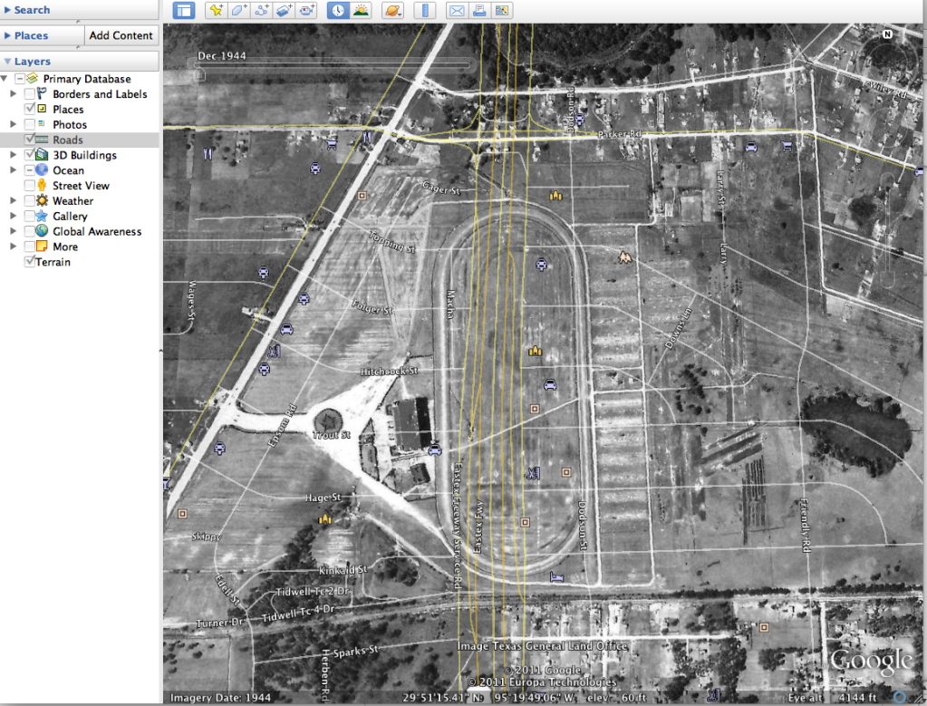
Found it on the 1944 google aerial, here ya go. Epson Downs
You can't find and evidence of it today because Hwy. 59 runs right threw where it was.
Wow that is some photo. I never had any idea the old Epsom Downs track was that big. It stretched from just south of Parker to just north of Tidwell. And you're right. The 59 freeway goes right through the middle of the land where the track used to be.
This aerial photo shows that area was "way out in the country" in the early 40s. It's completely developed now.
-
I've spent some of my off time researching the 1944, 1953, and the 1978 google historic aerials and noticed that at some point southwest Houston was the place to go for all kinds of racing. Would be nice to know the histories of these tracks.
Don't forget there was also a horse racing track just outside the city's north side. It was outside the city THEN, but the site where it was located is well inside the city now.
I'm talking about Epsom Downs out on Jensen Drive. It closed in 1937 when Texas outlawed parimutuel betting. A drive in theater -- the Epsom Drive-in -- was built on the Jensen Drive side of the property. That one closed in the 70s or 80s when drive-ins everywhere started going out of business.
Here's a link to the story of Epsom Downs on another page in another department here on the HAIF.
http://www.houstonarchitecture.com/Building/2004/Epsom-Downs.php
By the way, that arrow supposedly marking the spot of Epsom Downs is way off the mark by at least a mile. Scroll south on Jensen till you come to Tidwell and you can see the clear outline of the area where the racetrack was located. Zoom in close and you can tell the site had houses on it for a long time, but it's now a large Metro Park and Ride lot.
-
On 10/3/2011 at 10:54 AM, marmer said:
Yes. This is all true. I was eleven and living in Lake Jackson at the time. Savitch was arrested by (I think) Sheriff Robert Gladney for getting too close to the plane. Of course she was released shortly afterward.
The story I heard at the time was that Savitch was arrested when she physically attacked a Brazoria County Deputy Constable who had taken her camera-man's 16mm film camera away from him. She jumped on his back piggy back style.
Another deputy constable pulled her down and slapped cuffs on her. She was placed in a nearby police car, but she wasn't taken to jail because all the lawmen there were busy handling crowd control and security around that small airport, and nobody had time to drive Savitch to the jail in Angleton. So they let her go on her promise to behave herself.
I was a news anchor for KPRC Radio at the time, and that's the story I heard from one of our reporters who was there.
-
 I was just wondering if anybody remembers the Sam Houston Airport on old 90 just west of Chimney Rock back in the late 40's and early 50's? A great friend of mine lived right on the runway back in the early 60's and never new it. He's was a pilot in the Vietnam War. It's all covered up with housing now. Ran across it on Google Earth (historical time feature) back in 1953.
About five years ago we had an extensive discussion of that old airport here on the HAIF.
Here's a link to a great aerial photo. You're looking east along Hwy 90, or South Main.
http://houstonfreeways.com/images/sam_houston_airport_1947-11-00_overview_complete.jpg
Here's a link to a website devoted to old abandandoned airfields, including the old Sam Houston Airport.
http://www.members.tripod.com/airfields_freeman/TX/Airfields_TX_HoustonS.htm#samhouston
-
deleted
-
deleted

Most ruined areas of Texas
in Other Texas Places
Posted
I can remember when there were miles of open undeveloped space between Katy and the Houston City Limits. It's now one long continuous suburb.
The same thing is happening to U-S 59 from the San Jacinto River north into Montgomery and Liberty Counties. It's now continuous suburb all the way to Splendora, and it won't be very long till it reaches Cleveland.
I'm old enough to remember the scenic two-lane highway that ran from Houston all the way through east Texas to Texarkana. . The ONE good thing I can say about the multi-lane divided highway that 59 has become is that I can now drive from Angelina County to Houston in an hour and a half. It used to take between two and three hours, but we didn't mind all that much because the scenery was so nice. It's good that we can now whiz through quickly. Less time to see the ugly development.