

wilcal
-
Posts
1,716 -
Joined
-
Last visited
-
Days Won
3
Content Type
Profiles
Forums
Events
Posts posted by wilcal
-
-
1 hour ago, Luminare said:
This brings to what I have to say in response to this. Remember when I said that State/Fed money has strings attached. Federal money always has strings attached. When you get federal money its for a specific reason. Most of the Federal money we get for transportation is for Federal Insterstate highways. Probably the only reason why we have the TxDOT plan right now is because we can probably afford it with a chunk of funds coming in from the Feds because I-45 is a federal interstate highway. The Feds have invested interests because a better, new highway means better commerce for all (we could say this is a common interests to all votes and legislature) which is why they give those funds in the first place. The only other time they give money is for extremely local projects, but might have bigger repercussions for the local area that could improve commerce that could then affect the area and then the state and then the nation.
Lets also be clear that those federal funds were our money to begin with. It's sad that we run the biggest negative in terms of receiving federal road funding. We send out about 110% of what we get back. Yes, that's how being in the federal government works, but still annoying.
Brightline is 100% private (well, they almost just had an IPO after collaborating with Virgin), but getting to utilize some existing government/train ROW.
I understand what you are saying, and I don't necessarily think the state should be paying for high-speed rail to connect cities (although I wouldn't be against it) but the funds should certainly be available for other transit projects. Just the option! But it's been designed so there is no option, and that is heartbreaking.
-
 1
1
-
-
25 minutes ago, Luminare said:
To even get started on passenger rail and put money to that task they would have to do an incredible amount of work to get the foundations of an organization started.
They administer $25 billion/year. I think they could figure it out if Brightline can.
26 minutes ago, Luminare said:If you want TxDOT to do more than that then it means they will need to create a state run entity that builds publicly owned passenger railroads, but state doesn't want to increase the bureaucracy.
Isn't this why they changed their name from Texas Department of Highways? To be more all-encompassing? (an honest question here)
27 minutes ago, Luminare said:They will choose the easier path to build highways.
As I showed above, it's the only path they have.
28 minutes ago, Luminare said:This is why I believe if we want rail then we have to push it as a local matter that could then get private interests involved.
Then you'll never have access to state funds or the federal funds that are given to the state, and that's a shame.
-
1
-
-
1 minute ago, Luminare said:
Correct. The only directive TxDOT was given was that the funds be spent period. The framing is always highways because that is what TxDOT predominately does. It doesn't run a state owned passenger rail system so there are no funds which go to a state run rail system.
2TN.222.001 requires that funds in the State Highway Fund must be used to improve the state highway system or mitigate environmental effects of such system.
https://statutes.capitol.texas.gov/docs/TN/htm/TN.222.htm#222.001
The State Highway Fund takes constitutionally dedicated taxes and fees, Prop 1 Oil and Gas Taxes, Prop 7 taxes, and federal funds.
Here is your breakdown on State Highway Fund Revenue:

Only Special Vehicle Permits Fees, Sale of Publications/Advertising, Supplies/Equipment/Service, and Other Revenue are not dedicated purely to highways. Those total to just under 3% of state revenue.
And both of you may know more than me, but it's certainly possible that not all of the federal dollars ($11.31B for next year) heading into the State Highway Fund don't have to be tied to road construction/maintenance, but TXDoT is not treating them that way to my knowledge.
So no, there is nothing written into the state constitution that TXDoT must spend 97% of their revenue on highways, but they way that they have written constitutional amendments for funding via the props and other taxes have that effect. By all means, they could sell tens of billions in advertising and they could, at their discretion, choose how that money is used, but the other funds equal tied hands.
QuoteTxDOT uses funds to also go into bike lanes as well as its within the preview of transportation, and they have sections of TxDOT that are dedicated for that purpose.
I could be wrong, but to my knowledge, they are only administering federal funds, not their own (TASA stuff).
-
1
-
-
1 hour ago, Houston19514 said:
Pretty sure that's false. First, the legislature does not have the power to amend the constitution. That can only be done by the voters. Second, I can't find any such provision in the constitution. Can you provide a section number or other citation?
55 minutes ago, Luminare said:but...but the conspiracy! thats against the conspiracy of a TXDoT cabal scheming and plotting against us all! take those facts somewhere else!
Sorry, you are right technically. It was texas voters who approved it, but it was placed there by the legislature via a legislatively referred constituional amendment. The most recent one was 2015 Prop 7 which diverted more billions specifically into the State Highway Fund. They could have put those funds at the discretion of TXDot entirely, but they were locked into highway usage.
-
1 hour ago, august948 said:
What do they consider "high comfort"? To me that would be a grade separated hike and bike trail.
I believe high comfort is anything with separation between the bike lane and regular lanes. That can be paint-only.
Also, this project is listed as a CIP, not a Rodney Ellis $10 million project (like the Patterson bikeway). This means that it probably doesn't have the ultra-rapid implementation like the county-funded projects.
When the presentation does appear online, it should appear on this page: http://houstonbikeplan.org/11th-street/
-
1
-
 1
1
-
-
1 hour ago, samagon said:
I think txdot is foolish to not entertain any other form of transit than vehicular. they say Texas is not a mass transit state, they're right, and it's their fault Texas is built the way it is. they have the power to make a difference, yet they continue to put forward projects like this.
1The legislature wrote into the state constitution one or two sessions ago that 97% of TxDOT funds have to be spent on roads. So they can't even do public transit if they wanted to.
-
9 hours ago, Ross said:
I would be happy to make accommodations for bikes and pedestrians, but I always want to minimize the impact on current property owners and residents.
Fortunately, the City employees at the meeting tonight said Pecore was out of scope for the moment, as there's not enough traffic to really require striping modifications, and the traffic issues are almost non-existent.
I wasn't able to go last night. Can you give us any other comments/info from the meeting?
I'm surprised that they said Pecore didn't trigger on-street due to traffic count, but the numbers are the numbers. Basically, they want to paint sharrows there?
Did they want to split the bike lane across the median on the west side?
-
8 hours ago, Ross said:
Everyone knows that you don't own the parking in front of your house. However, on a street like Pecore, eliminating street parking completely means you can't even park a car for 2 minutes while moving cars around. Nor can a truck park to move your belongings. Will people survive? Sure, but at great inconvenience.
Shouldn't be a problem with a household full of drivers for all of those cars, right? 😁
Even if you didn't momentarily park in the bike lane like the other commenter suggested, the furthest house from a side street intersection is about 400 feet. We're not exactly talking about parking pandemonia like Philadelphia or something.
-
1 hour ago, gmac said:
If that's a bike lane pictured, it's a death trap.
It's Polk. I road it this weekend and it really really is.
It's also scheduled for proper bike lane infrastructure soon and the Lanier bike gutters will be replaced. The quality of the concrete is absolutely atrocious, so not sure what they plan on doing.
-
8 hours ago, wilcal said:
You are only required to "stay to the right" on lanes that exceed 14' in width. I don't think a separated bike lane is counted as part of that width. Chances are that it has not been legally tested and there is no clear cut definition.
I asked an industry professional, and any stripe creates a lane separation.
The only way a rider would have to ride "in the bike lane" would be on a street that is > 14' in a lane. No way for a bike lane to be part of a lane like that unless it was just sharrows.
-
On 3/2/2019 at 3:46 PM, Ross said:
There's another TxDOT response that's more applicable, from the same page:
If there is an on-road bike lane, does a cyclist have to use it or can they use the general travel lane?See the previous answer. Because a bike is required to stay as far to the right as practicable, this could be interpreted to mean if there is bike lane, a cyclist would be required to ride in it, as it would be the far right side of the road. However, if one of the exceptions listed in the previous answer exist, they would be excused from the "far right" requirement.
2You are only required to "stay to the right" on lanes that exceed 14' in width. I don't think a separated bike lane is counted as part of that width. Chances are that it has not been legally tested and there is no clear cut definition.
On 3/2/2019 at 3:46 PM, Ross said:Why do you hate the residents along Pecore so much?
On 3/2/2019 at 4:07 PM, gmac said:Probably because he/she doesn't live on Pecore.
I don't, but I am kind of fed up with people that think that they own the streets in front of their house. It's owned by the city, AKA everyone. The best use may not be for the city to subsidize their car parking. And as your example above, not even subsidizing their need for parking, but their need for the preferential arrangement of their cars parked at their property? That's a full on facepalm for me.
-
1
-
-
16 hours ago, Ross said:
The driveways on Pecore can handle three cars in length, but not width. That means some car will have to be on the street if another car needs to get out, and isn't closest to the street.
Please allow me to attempt to find my ultra small violin...
QuoteTxDOT website says if there's a bike lane, bicycles generally need to use it https://www.txdot.gov/inside-txdot/modes-of-travel/bicycle/know/laws.html
"If there is an off-road bike path next to the roadway, does a cyclist have to use it or can they use the roadway?No, provided the bicyclist adheres to all the discussed rules of the road and bike laws, bikes are entitled to all rights of the road that apply to a motor vehicle, including access."
?
Quote11th at Heights is 4 lanes, it's 5 at Yale, which has left turn lanes on 11th. There's no safe way to have a single middle turn lane on 11th at Heights, as there's only 40 feet of length to use. It would have to have 4 lanes to have safe left turns, or left turns would have to be prohibited from 11th to Heights.
That makes sense.
-
There is zero chance that they have the funds to re-do medians or really, lay any type of significant concrete. This will be a paintjob only. It's probably a Rodney Ellis $10 million project which have all been quick and dirty. I love going to bikeways meetings, but IDK about going to this one. I think there will be some serious vitriol.
On 2/27/2019 at 10:53 AM, s3mh said:I do have some sympathy for people living on Pecore. Most of them have no alley access and losing on street parking will have an impact.
I don't see any homes on Pecore that don't have a driveway, and there are few to no businesses that are leaning on street parking currently. I would assume that PWE has done a traffic study like the other bikeway presentations, and street parking utilization in the neighborhood will likely easily absorb the loss of parking.
QuoteHowever, it seems beyond stupid to tear out the treed esplanade between TC Jester and Durham
No way that'll happen purely on budgetary reasons. I imagine that they'll do a bike lane on each side of the road and it'll match traffic direction.
On 2/27/2019 at 8:25 PM, Ross said:Eliminating on street parking on Pecore will totally screw any home owner who has more than one vehicle, since most of the houses have a one car wide driveway. If there's a garage apartment, or a teen driver that brings total car numbers to three, it's going to be bad.
Most of the driveways I'm seeing will handle 3 cars in them without a problem?
On 2/27/2019 at 8:25 PM, Ross said:If there are dedicated bike lanes, are the groups of 20 riders I see in the mornings going to ride single file in those lanes, or take up the single lane available for cars?
They can choose whichever they want. I saw your further comment, and no, no legal requirement to ride in a bike lane (although you'd be kind of a dick if you weren't reallly close to the speed of traffic).
On 2/27/2019 at 8:25 PM, Ross said:Pecore right of way is 10 feet narrower than 11th, which will make it more difficult to fit all of the proposed lanes.
If I had to guess, you'll see the Lamar St style bike lane in that section with the drive lanes shifted up or down due to the lower ROW and a bike just on one side.
On 2/28/2019 at 1:58 PM, Triton said:If they do end up going through with this, then I think they really need to focus on the major intersections to make sure there are left AND right turning lanes, along with a straight lane. If not, I can see traffic REALLY building up along 11th, particularly at TC Jester, Shepherd, and Yale.
With a middle turning lane, why wouldn't those be used as turning lanes at major intersections? (Like W. Alabama throughout Montrose). 11th at Heights is much wider, too with there being 5 lanes across.
-
This may not be news, but Whole Foods is killing their 365 store label. Wasn't this location originally going to be one?
Either way, it'll be just a normal Whole Foods now
https://www.eater.com/2019/2/27/18243123/whole-foods-365-stores-rip -
- Popular Post
- Popular Post
On 2/16/2019 at 2:01 PM, bobruss said:Thats one of the things out of town visitors always seem to mention is How lush and green Houston is.
It's our best natural feature. And if you look at old pictures of Houston, you'll notice that most of the trees were planted by us.
There were natural pine forests but the majority of other trees were added. Thank goodness.
I took this from Hotel ZaZa two years ago. Unbelievably lush area
-
11
-
3 hours ago, BeerNut said:
Thanks for post @wilcal I live on Hutchins and was disappointed I was going to miss this meeting due to work. Speeding is an issue on Hutchins so hopefully this will slow traffic down to the posted speeds and the bike lane will be icing on the cake. I noticed at some point last year they put white lines for a kinda bike lane on Hutchins near Emancipation Park . I've included a pic of the curb build outs when they were new.
3Part of the plan that I didn't mention is for median blocks for Hutchins at Alabama and at Elgin actually.
It'll be interesting to see the final configuration and how traffic flows. I think a lot people use Hutchins as an access road for 59.
-
1
-
-
Residents were mostly positive about the plans. The one negative comment I heard was about loss of parking for residential on Blodgett.
The city talked about how they did a traffic study and the speeds were way high and that it wasn't safe to put on-street shared here. 1:6 drivers were driving higher than 40 MPH and that number skewed even higher as you went further east.
Two residents said that they were very unhappy with the curb build-outs at Hutchins/Tuam and were happy to have them be removed and bike lanes added in. They said tons of people are braking their cars while driving into them.
I asked and was specifically told that all of the above projects had the budget to be implemented this summer.
My concerns are that there really isn't a good east/west option through Midtown (I almost got hit twice on McGowen while riding to this meeting last night). Some option of McGowen may have, but it would be in the future.
@Urbannizer I know this isn't a widely used forum, but should we figure out some way to combine some of these threads? Like a Rodney Ellis $10 million megathread?
-
3
-
1
-
-
Last night I went to the 3rd Ward bikeway system meeting. This is for one of the sections that the city is focusing on using the $10 million from Rodney Ellis to build high-comfort bike lanes.
There were probably about 20ish citizens there and about 15 city planners/contracted engineers/etc.
First, the map! They didn't have an updated whole map that showed the changes that they've made in the last few months, so I whipped up my own.
Green - existing high-comfort bike infrastructure
Blue - proposed and imminent high-comfort bike infrastructure
Purple - "Community Bikeways" aka sharrows . No separation from vehicles.
Red - Bike infrastructure being handled by those other than the city or projects that are planned but I don't have specific info on (like Polk. A city project but I have no/they haven't presented updated info).
Timeline: finalizing design work by March. Starting construction in April on all projects. Most blue/purple projects completed by end of the summer.
The new information can be split into changes on four streets.
1) Gray would run from Brazos in Midtown to the Columbia Tap Trail. Split into 3 different designs based on road width.
Brazos to 288 (converting parking on one side of the street to a bi-directional bike lane)
288 to Live Oak (converting parking on one side of the street to a bi-directional bike lane)
Live Oak to Columbia Tap Trail (sharrows)
2) Hutchins: adding bike lanes and reducing lane sizes. No reduction in parking.
3) Blodgett: Elimination of parking on both sides of the street and converting to protected bike lanes
4) Cleburne: Elimination of parking on both sides of the street and converting to protected bike lanes
-
6
-
1
-
-
33 minutes ago, bobruss said:
Obviously nothing sinks in with these elected officials whose plans must be greased.
1I don't think a single elected official wants this to happen.
-
9 minutes ago, BeerNut said:
What percentage of employment and tax base is encompassed inside the Loop?
I'm not sure. Inside 610 is 97ish square miles and the H-GAC represents 12,444 sq miles (.779%). You can see in the linked PDF that half of the score that they calculate comes from a cost to benefit ratio, and that benefit is calculated based on usage. It's clearly not aimed purely at relieving traffic as the lower Westheimer scored pretty well while being classified a road diet.
Basically, what I'm getting at is that they are attempting to normalize for usefulness without factoring in what part of the area it is in.
Also, I did find a population number for inside 610. In 2010 census it was 443,949. The highest was the 1960 census at 493,377. I bet we eclipse that in 2020.
-
1
-
-
15 hours ago, BeerNut said:
So the number 1 major funding is for BRT/HOV on I10 downtown to 610? Does this mean this will be funded without funds from the bond referendum?
Basically, yes. BUT, I don't think it's actually a part of the scheduled bond referendum projects because they were counting on this.
H-GAC said that they will have funds to fun only 1 of the 3 "major" projects.
Also, from what I heard, this two-way HOV/BRT will be elevated. They are selling it as a flood-proof connection from dowtown Houston center of government to the Transtar/County Operations center thing at I-10/610.
-
4
-
-
16 hours ago, Luminare said:
EDIT: I get it. There is a significant population in this city that lives in the suburbs, and these areas need to be served as well, but the trend is people moving into the inner city. Plus the roads in town are in way worse shape than anything beyond 610.
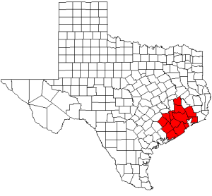
Houston-Galveston Area Council serves a 13 county area in SE TX. Inside 610 really doesn't have that much population compared to the rest of it. Isn't the pop like 200k? It's pretty low.
-
The City of Houston submitted the Lower Westheimer S. Main to Shepherd portion to the Houston Galveston Area Council to try to obtain federal funding. It was the only road diet project submitted that I saw.
They released draft rankings (PDF warning) in January and it was ranked 20th out of 63. Unfortunately, HGAC only has funding for the top 10 projects.
The cost estimate was $33,432,000 and HGAC calculated the benefits to be $96 million. They requested funding for the 2023 year.
It did not fare particularly well in the "Planning Factors Score" which I'm not sure how exactly that is calculated.
I believe they are letting everyone revise their application once, so we'll see a new rankings in the next month - 3 months I believe.
-
 1
1
-
-
16 hours ago, Visitor said:
I think you're missing what I'm saying on our differing opinions. I would rather do nothing than do it 1/4 of the way. The infrastructure I referenced was moreso related to the redistribution of the parking they remove. General infrastructure is a much larger problem in Houston than bike lanes to me. And I do ride often, not spandex ride, but I will often bike to places to eat and run small errands.
1Interesting. What would you do for this project if it was 4/4 of the way?
Also, I could be misremembering, but isn't it only in the range of 20-30 spots that are being lost?


Bike path on 11th and Pecore
in Bicycles and Other Low-Impact Modes
Posted · Edited by wilcal
They have been typically using painted separation/addition of armadillos of a few feet on higher traffic streets. So a little better, but not wonderful.