

gnu
-
Posts
1,146 -
Joined
-
Last visited
Content Type
Profiles
Forums
Events
Posts posted by gnu
-
-
Weird. So this thread with my 2006 post seems to be disconnected from another thread. I am not sure where that thread is, but there is not much info in this little two post thread.
I found this thread, that will give context to the posts above about the Scanlan House or Mansion in Sienna.
https://www.houstonarchitecture.com/haif/topic/38662-thomas-scanlan-mansion-at-1917-main-st/
BTW, the title of the thread in the link above is confusing should not be 1917 main st. That was the address of the Scanlan mansion in Houston and that thread does not discuss anything about it specifically.
Just to clarify: The Scanlan Mansion (a very Victorian looking house) was at 1917 Main (1891-1937) and after a disagreement with the city, the Scanlan sisters had the house disassembled and built into a new structure (New Colonial?) on their land in Sienna (evidently now 714 Scanlan Rd) - and now demolished (1937-2017). Links in the other thread detail this.
-
 1
1
-
-
The original Friendswood School Building is the narrow one facing W. Spreading Oaks. The Museum is in part of it.
I believe the one marked AA Gymnastics Academy is a gym.
The Junior High has moved and this campus is no longer an active school.
-
1
-
 1
1
-
-
On 9/2/2023 at 9:21 PM, Highrise Tower said:
Does anyone know what this tall smoke stack located in the Hermann Hospital campus was used for?
Incinerator? Schools had them too
-
1
-
-
On 5/7/2023 at 11:42 AM, SpaceGhost said:
There are lots of references to the building from 1938, specifically naming Kenneth Franzheim, who at the same time was commissioned to design Lamar HS. You can draw some similarities between the designs of the two buildings. According to this article the building was planned to be next to the existing Taylor School, facing Smith Street, so about where the parking garage across from the old library is.
The Taylor School was at 1500 Louisiana (later to become Enron South). It appears it was a vocational school. Thus the likely address for the above proposed administration building would have been 1500 Smith (the hypothetical block bounded by Smith, Bell, Leland, & Brazos).
Smith ended up being the only street mentioned in the article that was pushed through (and Allen Center was eventually built where the Bagby and Brazos right of ways would have been).
According to city directories, the administration was split between a building at 1600 Washington (business office) and the building at 1500 Louisiana (sharing the building with the vocational school) until 1955. Then it consolidated operations and moved into the old Sam Houston High School at 1300 Capitol (currently the site of HSPVA) until the Taj Majal was built on Richmond.
-
1
-
-
11 hours ago, JCR said:
If it was so prone to flooding, they would not have put a small cemetery there. 🙄
-
2
-
-
8 hours ago, FilioScotia said:
We sure talked this to death back in 2005. Did we ever come to an agreeable conclusion? My old memory ain't what it used to be.
My memory isn't what it used to be either, but I think we sort of agreed it was just a development that never really came to fruition - other than the platting
-
2
-
-
8 hours ago, FilioScotia said:
On present day Google Maps Houston satellite view, there's an undeveloped area on the east end with a long oval that looks suspiciously like it MIGHT have been a race track at one time. It's just west of the the East Loop 610 just north of Clinton Drive. Check it out and see what you think.
Oh you mean here? 🙂
-
1
-
-
Before the early sixties, Lockwood through the Eastwood area was called Maplewood.
The bowling alley could have been on that street. I know there was a Maplewood Pharmacy at Harrisburg and Maplewood (Lockwood)
-
1
-
-
An example in Pearland
https://www.google.com/maps/@29.562643,-95.2836617,177m/data=!3m1!1e3
40 minutes ago, editor said:"parking would be in the middle of the street, usually angled. "
-
1
-
1
-
-
4 hours ago, editor said:
This is the one I bought. It's not very good, but it gets the job done. It has a number of flaws, including the inability to record something if that program goes past midnight. It's just a single tuner, so only one program can be recorded at a time. And if it's recording something being broadcast in 1080, it breaks the recordings into hour-long segments. If you're on a Mac, that's not a big deal because you can just stick all the bits together with QuickTime Player in two minutes.
Again, it's not great. The remote is not great, and the interface is clunky and poorly translated from Chinese. But it's $25.
I schedule all of my recordings for the next two weeks, and then just let it run. Two weeks later, I transcode the files into my AppleTV and watch them there.
Ah. I always ignored these because I thought it was for analog conversion only. I may have to check one of these out.
-
What I want to know about is a DVR that can record OTA and output to my digital tv.
I have found several options over the years but none have made me interested enough to purchase
-
This is the Carter Building.
Currently the Marriot at Main and Rusk
-
5
-
1
-
-
This is the 1883 Courthouse. It was demolished and replaced in 1910.
-
3
-
-
-
Corn Dog 7?
-
Not that this is the least bit interesting but....
When I visited my uncle in Rice Military, as a kid, I would usually walk to the Lucky 7 Birdsall Supermarket at 231 Birdsall (now multiple townhomes since about 2003) to pass the time, get candy, etc
BTW. His house was also replaced with 2 townhomes in 1998-ish.
-
2
-
-
-
1
-
-
11 hours ago, MidCenturyMoldy said:
I think that "movie theater" is actually a liquor store. Pretty sure it says "LIQUORS."
On 7/3/2019 at 8:14 AM, Subdude said:Nice pictures! Can anyone identify the street with the accident in front of Jack-in-the-Box?
On 9/1/2019 at 4:58 PM, IronTiger said:Unless the lens is extraordinarily screwed up, the intersection isn't perpendicular. The other road is wide, accommodating three lanes on each side, which eliminates a lot of options. There's also a movie theater in the background.
I don't know why i didn't notice the angled street intersection before. That makes it almost obvious to me that it is the corner of Telephone and Dumble.
https://goo.gl/maps/sYPg1NR1GogPrueQ7
There is still a liquor store at the same spot today.
-
2
-
2
-
-
2 hours ago, Reefmonkey said:
...Bank Draft Brewing Co..... Huey's...... Bay Brewery Steaks & Seafood in Seabrook ....
Huey's! That was it. And the Vault was of course was the Bank Draft and they had a vault. duh!
Forgot about the Bay Brewery. They had a great back deck that overlooked the Bay.
There was also another brewery in Galveston maybe the Galveston Brewery? It was south of the Stand on a sw corner.
-
It was just called The Village Brewery and it was on Dunstan in the old post office.
Across the street was The Vault which was more of a brewpub.
On Richmond there was Rock Bottom (chain) and the Houston Brewery.
Also, Bradley's in Clear Lake
There was also one on the North Freeway somewhere near Richey on the west side of the freeway. Name slips me right now.
There was also a small brewpub on Highway 6. The name also slips me.
May have been a few others but those are the ones I remember.
-
1
-
-
Okay so the property on Graustark at 59 seems to be the Pauline Sterne Wolff Memorial Home for Widows and Orphans.
A google search says the home was the first Jewish orphanage in Texas and her fund still seems to be around according to this post from 2015
http://jhvonline.com/jfs-senior-adult-service-wing-to-carry-benefactors-name-p19236-109.htm
"Pauline Sterne Wolff’s name is known through the many programs and facilities made possible by the foundation, a legacy that has profoundly impacted the city of Houston. Pauline Sterne Wolff died in 1921. The Wolff Memorial Foundation began with a $600,000-plus estate; $100,000 of the estate was used to buy land and build the Pauline Sterne Wolff Memorial Home in 1930. For decades, the home provided a safe and nurturing place for Jewish orphans to grow and flourish."
-
3
-
-
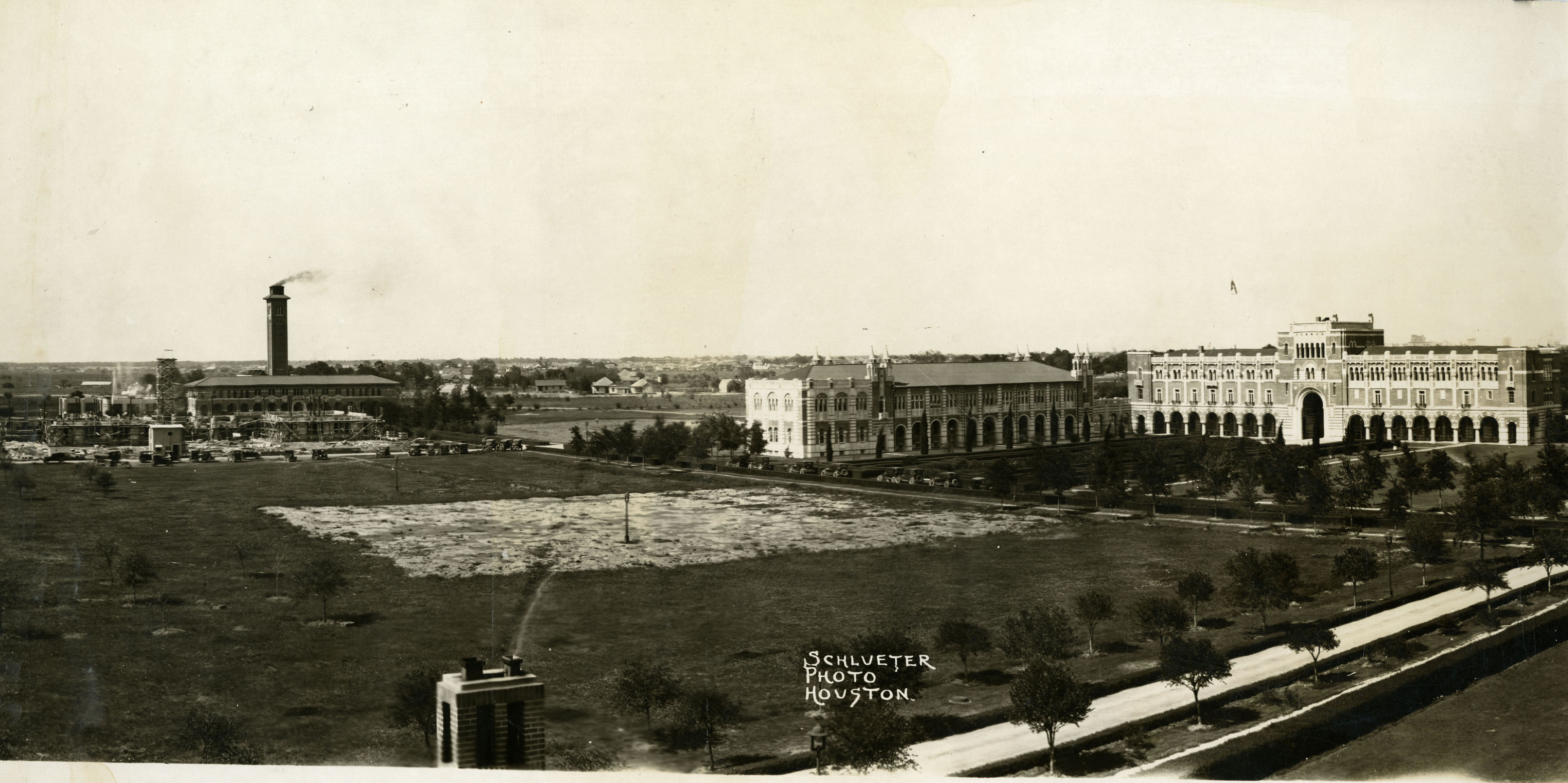
I searched all through the Sanborn maps for any possible building and there doesn't seem to be anything that fits the bill.
I even tried to triangulate the location of the building from the photo you posted above and another Schlueter photo from the Rice History Corner posted on March 27
https://ricehistorycorner.com/2018/03/27/chemistry-building-construction-circa-1925/
https://ricehistorycorner.files.wordpress.com/2014/03/oversize-chem-construction-1925.jpg
Based on my amateur analysis, I determined that the building should be between two N/S lines formed roughly by Graustark and West Blvd and as far north as Richmond.
I redoubled my efforts in the Sanborn maps and the City Directories.
I searched the lists of schools and apartment buildings. The Kinkaid School was there but it was one story and faced north.
There doesn't seem to be anything. Also note that the 1924 Sanborn maps don't go west of Institute, so it might have slipped off the left of the map.
I wonder if maybe it wasn't around long.
I decided to search for other Schlueter photos but I could not find anything else to really help. I did find a photo of this unidentified building that could possibly pass as the subject building. Unfortunately it has no location or identification.
http://digital.houstonlibrary.org/cdm/singleitem/collection/schlueter/id/207/rec/19

-
2
-
-
Okay, my original thought was Gulf Freeway at Scott but when I pulled up streetview it seemed too far away.
But I just looked at my 1976 directory and it shows a Gulf and a Mobil at that intersection.
Probably just a coincidence as the angle doesn't look quite right between Scott and the freeway either.
-
Just guessing but it would seem to me it would have to be Gray or Calhoun (St. Joseph) since it is one way inbound.
This would also work with the billboard and the tall Gulf sign, that would be visible from the Gulf Freeway.
Maybe Gray and La branch? Seems to sorta work from street view.


Historic Houston Schools
in Historic Houston
Posted · Edited by gnu
duplicate entry
Original Brookline Elementary burns yesterday
https://abc13.com/vacant-building-fire-near-telephone-and-griggs-road-in-southeast-houston/14608340/