

isuredid
-
Posts
506 -
Joined
-
Last visited
Content Type
Profiles
Forums
Events
Posts posted by isuredid
-
-
I spent a lot of time there as a kid. It was quite a hike from our house in East End to get there, or at least it seemed so back then, but it was a pleasant drive. We would go up Telephone Road to 518 and cut over from there. Once you got past Hobby it was all very rural. I think the official name for the place was SERA which stood for Shell Employees Recreation Area, but we called it Shellwood too. The employee picnics were always catered by Lennox Bar-b-que (yum). I learned to swim in that pool. We would fish in that lake, but never caught anything but small perch. I was really more fascinated by the creek or bayou which had lots of turtles, snakes and alligator gars in it.
-
Maybe I'm just crazy, but from my childhood in the 1950s, it seems that what is now called West Mount Houston, was designated as W. Mont. Houston. As in West Montgomery-Houston Road, because that road led from Houston to West Montgomery County. Can anyone clue me in on this?
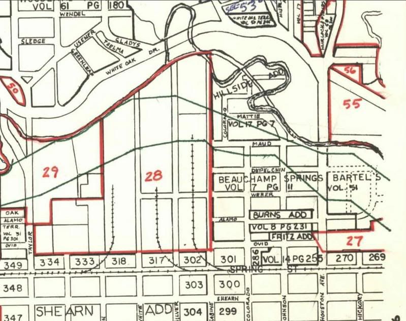
Mount Houston is a subdivision off of Homestead Road. It was always Mount Houston. Here is a link to the block book map for that subdivision. You can see in the map that some of the street names have changed, but most are still per the original plat.
-
 1
1
-
-
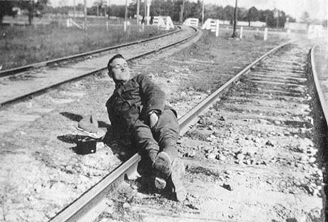
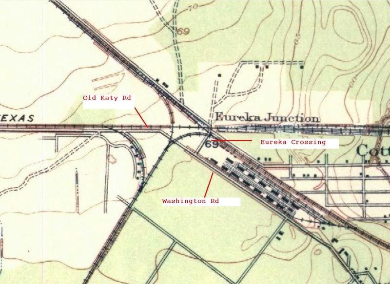
I have metal detected in the area where Old Katy Road crossed the R/R tracks. I have also been to where the Eureka Road crosses the tracks also. I have 2 pictures of the spot at Old Katy Road and the tracks taken last year. One was taken on the east side of the tracks, and one was taken on the west side of the tracks.Both were taken just on the north side of where Old Katy Road crossed the R/R tracks. The soldiers picture was taken on the east tracks, on the north side of Old Katy Road.
That is the only spot where the tracks curve outward at both tracks.It is on the map you show posted. The small curved tracks just on the south side of the Old Katy Road were part of Camp Logan also.
The old Katy Railroad tracks ( now gone) can be seen in the background of the soldiers picture laying on the tracks.
I studied the soldier photo again and I now agree with you that the location of the photo is likely where you say it was. This is, not only for the reasons you state but also because of the soldier's shadow. If the soldier were on the tracks in my photo his shadow would be pointing south, and that can't happen.
-
I hate to say this, but that is not where the soldier laid on the R/R tracks. If you look at the old picture where the guy is on the tracks,the tracks on the right side of the picture curve toward the right. The tracks on the left side of the picture curve out toward the left. Only one area in Camp Logan had the tracks like that, on the north side of where Old Katy Road crossed Washington Road.
The area you describe was wooded at the time (still is). I don't see any evidence of that in the photo. And that looks like the Eureka Crossing of the Washington Road in the backgroud. Another point is that Old Katy Road crossing was just above the fork or junction. The soldier photo shows two clearly separated tracks with the road crossing still ahead. The track on the right in my photo does curve off to the right, although that may not be visible in the photo I posted. The photo I took would also have been close to the Eureka Station which seems a more likely place for a soldier to be who might have been coming from or going into Houston on the train. There wasn't anything in the area you described execpt a grove of trees which are not visible in the photo.
This map was drawn while Camp Logan was still intact
-
When I was very young kid (born 1953) there was an old house on a couple of acres not too far away from our home off Southpark (now MLK Blvd.) that was operated as a Italian resturant by what seem to me to be a Italian family. Absolutly great food and homey faimly atmosphere. The house was, what I can only describe as a country mansion and they had turned all the downstairs room in to mini-dinning rooms much like Steak and Ale does. I remember as kid it seemed to me like a country inn stached up from Europe and dropped down here in Texas, bu then again I was a kid, so it may have been nowhere as impressive if I had been an adult.
TEX
The Restaurant you are referring to was Galli's Spaghetti house. The owner, Mary Galli, passed in 1999 at the age of 103. Great place that I wish I could go back to.
-
Not sure this is all relevant but I remember the hill at the Hermann Park Theater (where they have the outdoor musicals and plays and bands now) being referred to as Hippie Hill.
Well, it's certainly relevant to the 70s in Houston, which is the topic. I was only 15 at that time, but I used to ride my bike from home in the East-end along Brays Bayou to Herman Park just to hang out on the hill on week-ends. It was probably as close as Houston came (not very) to the Golden Gate Park scene in SF. I remember that people would climb to the top of the roof over the theater to smoke their joints or pipes so they woudn't get busted. It was groovy,man.
That scene didn't last very long.
-
One of my favorite places was Mize's bakery and sandwich shop. It was a really small place wedged between Weingartens and the Bank. THey made great sandwiches and I ate there a lot when I worked at Joskees.
I always made a point of going to Mize's Bakery for a sandwich whenever I went to Gulfgate. They had some kind of steam heat contraption they would put the sandwich in to heat them up and melt the cheese. I guess it made the bread tastes fresher too. I wouldn't mind having one right now.
-
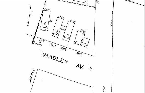
At least up to 1951 there didn't appear to be anything at 2808 Hadley. There was a house at 2807 across the street. Someone could check the city directories for 1959-60 to see if 2808 Hadley existed then. If it did the directory would show the occupant and their occupation.
This is the Sanborn Fire Insurance Map for that block in 1951. 2808 Hadley would have been right on the corner of Hadley and Sauer streets:
-
-
This is the verbage of the original sale of lot 2 in block 13 (1518 Weber) in 1906. This should remove any futher lingering doubts, that there was ever any structure on that land before that date
File No 13612 General Warranty Deed
From Julia Bartels To W.H. Taylor
THE STATE OF TEXAS, County of Harris
KNOW ALL MEN BY THESE PRESENTS
That I Julia Bartels a feme sole
of Harris County, Texas for and in consideration of the sum of Five Hundred and Fifty ($550.00) dollars to me in hand paid by W. H. Taylor of Harris County, Texas as herinafter set forth and expressed
have granted, bargained, sold and conveyed and by these presents do grant, bargain, sell and convey unto the said W. H. Taylor all that certain land and premises situated and described as follows to wit - Lot No Two (2) in Block No Thirteen (13) of the Beauchamp Springs tract, an addition to the City of Houston on the North side of Buffalo Bayou in Harris County, Texas, said lot fronting upon Weber Street- the fuil width thereof and extending back northwardly full depth of said lot according to the plat of said Beauchamp Springs tract recorded in Vol 67 page 194 of the Deed Records of Harris County, Texas, the said W. H. Taylor has executed his eleven certain promissory notes each for the sum of fifty dollars ($50.00) payable to the order of said Julia Bartels, the first one of said notes is due and payable six months after date and thereafter at intervals of every six months, one of said notes is due and payable. All of said notes bear interest from date at the rate of eight percent per anum, the interest is due and payable semi-annually. Said notes provide that if default is made in the payment of same at maturity and they are thereafter placed in the hands of an attorney for suit or collection then the futher sum of ten percent of the principal and interest then due shall be paid as attorney's fees. Said notes further provide that all taxes accuring against said property hereafter shall be kept paid and the interest paid semi-anually and any improvements that may be erected must be insured for the benefit of the holder of said notes and failure to pay interest when it is due or the failure to pay taxes on said property till cost accrue or failue to so insure said improvements, or failure to pay either of said notes at maturity shall in either event at the option of the owner and holder cause all of said notes to at once become due and payable, and in order to secure the payment of said notes a Vendor's Lien is hereby retained against the herein above described property to remain in full force and effect until said notes shall have been fully paid.
To Have and to Hold the above described premises, together with all and singular the rights and appurtenances thereto in anywise belonging unto the said W.H. Taylor, his heirs and assigns forever, And I do hereby bind myself, my heirs, executors and administrators to warrant and forever defend all and singular the said premises unto the said W.H. Taylor, his heirs and assigns, against every person whomsoever lawfully claiming or to claim same or any part thereof
Witness my hand on the 27th day of February, 1906
Julia Bartels (her mark)
Signed and delivered in the presence of
Ira P. Jones
F.W. Bartels
-
Yes, very interesting.
Looks as though the house could date to 1856, and was moved to 1518 Weber.
Am I understanding all this??

The Puls house was made of wood, as all rural houses in Houston were in 1856. You couldn't begin to move that brick house unless you moved it brick-by-brick. The Puls house was not the 1518 Weber house. The Puls family had to move their house because otherwise it would have been in the middle of the recently designated streets. As noted in the affidavit, Frederick Puls was still living in the old Puls homestead at 1718 Weber in 1913. Besides that, the Bartels family owned 1518 Weber which was an empy lot unitl 1906.
-
-
I found this affidavit an interesting read:
Frederick W. Puls Affidavit
State of Texas County of Harris
Before me, the undersigned authority, on this day personally appeared F.W. Puls, who being by me first duly sworn says on oath as follows:
I reside at 1718 Weber Street, in the City of Houston, and am in business at 1720 Weber Street. I am sixty-three (63) years of age, and have resided in Houston all my life. I am a son of Frederick Puls, who purchased and owned those three certain parcels of land out of the Beauchamp Springs tract in the City of Houston, Harris County, to-wit:
(a) (10) ten acres conveyed to Frederick Puls Feby 23, 1853, by Harrey H. Allen Vol. P pg 294, Deed Records, Harris County, Texas. (
 One and one half (1 1/2) acres conveyed to Frederick Puls May 22, 1854. Vol. P. pg. 423, Deed Records, Harris County Texas.
 -
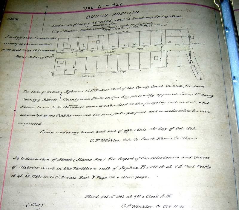
Koertge also wanted to get in on the subdivision building. I can't figure out why this is called the Burns Addition
-
The Ramones at somewhere in Houston in '78
The Ramones played at a place called On the Border, which was way out Telephone Road by Hobby Airport. I saw that show and that might be the one from 1978. I remember Joan Jett also played there.
-
My grandmother was born in 1898 in a house just north of White Oak Bayou from this property. Her family's house was near the location were Quitman crosses 1-45. The house were cleared in the 1950's for the freeway.
Too bad. Do you have a photo of the house?
-
Neat! Fred Puls was quite a character...
In a 1913 map, a Puls St. existed (currently the area at 45/10), but the grid was not in alignment there, as it (erroneously) showed in the 1907 map above...
That Puls street only existed on maps. The east side of Houston Ave was never devleoped because the city wouldn't agree to maintain the streets due to the terain. There was a large and long gully that ran through that area and the spring probably made it rather swampy too. Later Frederick Bartels replatted that area as the Bartels Addition, but that never took off either. Eventually they sold the land to the Ingersol Amusement company which operated Luna Park, an early amusement park, on that land for a number of years. Later on there was another Puls Road that did exist in the Garden Oaks area. I don't know why that street name changed. It was named for the same family. They also owned some land up there in the Garden Oaks area. Puls Road was renamed Alba. Seems like there should be a Puls road somewhere in Houston still. but there isn't. Too bad.
-
If you go to Volume T 81-100 of the Civil Courts minutes you can see a land dispute between the Koertge and Schott families over their properties in that area. There are some crude maps in there too. Thomas D. Beauchamp shows up in these early minutes quite often until his death in 1841.
-
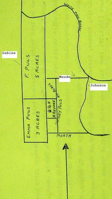
This map shows how the Puls land was divided after Frederick Puls Sr. died. The land jutting out from the original long narrow tract was purchased by Frederick Puls from Christiana Bartels. One reason for that purchase was to give Puls access to the Mongomery road (Houston Avenue).
-
Apologies in advance for flooding you with questions...
I see now that the name I couldn't read before could be "Bartellos" - Is the Bartellos family the same as the Bartels family?
Are those other two names Navel and Koertje?
Do you know if all of Thomas Beauchamp's property was to the south of White Oak Bayou? I had been confused about that because some sources say that the main street of his settlement was Beauchamp St., and others say Spring St. (now Johnson St. - not what is now Spring St.). If the settlement was south of the bayou, I'm guessing that the current Beauchamp Street in the Woodland Heights is not the same Beauchamp St. - or is perhaps just an extension of it.
Above Frederick Puls the name is Ravel. I'm not familiar with that person. Just below the name on the map says "Koertje", but the spelling should be Koertge. Directly south of Puls was Henry (Heinrich) Guese. The Guese house was moved recently to Old Sixth Ward and is currently being restored. The name for Christina Bartels on the Wood map says "C. Bartelles". East of Guese at the bottom of the Beauchamp Springs tract is Wichmann which is spelled Wickeman on the map and next to that it says "Fritz". I believe that is the Fritz Weber tract.
Yes all of Thomas Beauchamp's property was below or south of White Oak Bayou. The Beauchamp street from early records would be the same as Houston Avenue and this was also referred to as Spring Street in early records. Not the same as the Spring street of today and not the same as Beauchamp street in Woodland Heights.
The Puls and Bartels families referred to that road as the Montgomery road because it connected to the main Montgomery road north of there. In the 1870s the Bartels and Weber families built a bridge across White Oak Bayou where Houston Avenue is today. Later they turned the road and the bridge over to the City of Houston.
The Bartels land to the east of Houston avenue was platted in 1893, but the city refused to maintain streets in that area because of the spring I assume. Later on that land was used as Luna Park, which I believe has been discussed in another thread on this site. The Tri-Gas business now sits on the old Luna Park property.
The boundries of the original 1838 Beauchamp Springs tract would be Sabine Street on the west, The bottom of the Geuse property is the bottom of the tract, or you could say that the top of Spring Street is the bottom of the Beauchamp Springs tract, and on the east the boundry was just to the west of Holly street. The bayou, of course, was the top of the tract.
Frederick Puls sold two acres at the bottom of his long narrow 10 acres to Heinrich Guese. Originally the Puls property ran from the top of the Beauchamp Springs tract to the bottom.
-
This map shows the Weber property above Beachamp Springs. Frederick "Fritz" Weber was, I believe, related to the Bartels through marriage. He originally bought an acre or two at the bottom of the Beauchamp Springs tract, but later moved up north of the Bayou. He is the person for whom Weber street is named
-
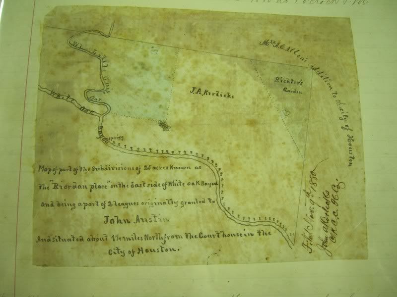
This map shows the location of the Riordan spring, which had been described as "an inexausible supply of pure water"
-
First off, fascinating write-up!!!
So the deed restrictions from the 1906 sale is why a new home cannot be put there today?
Anyone that thinks deed restrictions can replace zoning, I will refer to this example many times when I call you silly later on in life.
I believe the current owner placed the deed restrictions on the property.
-
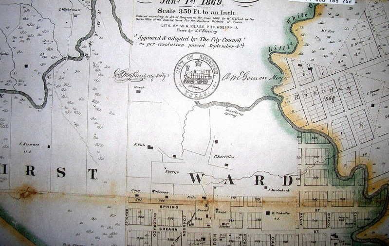
Here is detail of the area from the 1869 Wood map. That gully running south from the bayou was located where Johnson Street is now. You can see from the map that there was no stucture east of the gully, where 1518 Weber is located.


Shell Employees Recreation Area/Shellwood Park On FM 518
in Historic Houston
Posted · Edited by isuredid
You just reminded me that the place was full of bugs. There were only a few buildings, one for the pool and another bathroom down by the lake, that were made of cinderblock. I remember lots of daddy-long-legs spiders and those big red ants and, like you said, the horseflies