

nm5k
-
Posts
214 -
Joined
-
Last visited
-
Days Won
1
Content Type
Profiles
Forums
Events
Posts posted by nm5k
-
-
anyhoo, what is your take on this, guys? I cannot quite tell from the 47 photo exactly where the airport really was. The look of the bend in Willow Bayou is throwing me off. Sorry if this post is too long, or has too many pictures..
stu

The best way to get your bearings is probably by using main and it's
center "cross-overs" as a guide. IE: it's easy to see where the entrance
is in the 47 and 60 pix. You can see the entrance from main in each,
and the center crossing at that point. This crossing from main was just
west of where Landsdown is now. The airport roads are darker than the
new streets in the 60 pix. I was comparing them the other day, and
judging from the crossings on main, what is now Chimney rock, would
be just about at the end of the runway threshholds looking east.
Note that Chimney rock is just west of the first crossing east from the one
in front of the airport. That crossing is also east of that road/easement,
or whatever that runs to the water tower. In the 47 pix, I seem to faintly
see that easement just past the runways. I think the next two crossings
are the motor hotel area, and I think the clutter of buildings near the
top of the pix, to the left of main is Post Oak. I think the bend in the
bayou you see in the 47 pix is actually near the gasmer/willow intersection,
but not totally sure. That would be about where the old Westbury Hospital
would be. That airport covered quite a bit of area. I think you would be
able to see W. Airport in the left part of the 47 pix, if it had been there at
that time.
MK
-
 1
1
-
-
O'Bryan was supposably once worked at the TSO
in Meyerland. That where I first got specs when I moved
to Houston. I might have even seen the guy at some
point.. The boat shed where a lot of the Dean Corll
bodies were dug up is not far from here.
Yep, halloween went dead after pixie man did his deed..
But also.. The 4th of July has always been lame in
Houston. Why? Cuz ever since I've lived here, fireworks
have been illegal. In KS, etc when I was young, we could
and did shoot fireworks anywhere we danged well pleased.
That all ended when we moved to Houston. They had
banned fireworks in like 68? or something like that
due to too many houses burning down. And much of
that was due to the dangerous wood shake shingles
many houses used back then.
MK
-
>So it's completely covered now by Westbury? That's a shame. For the airport >I mean. Thanks
Yep, that whole westbury south took it over. The long
SE/NW runway crossed what is now W. Airport between
Chimney Rock and Hillcroft. If you've driven that
section of W. Airport, you've driven over Sam Houston
airport. Supposably, the actual airport property extended
to nearly the Willow Bayou, but of course, I'm sure the
runways stopped pretty well short of that point.
The old entry road from Main is totally gone too.
A soundwall is there now I think.
As far as I know, there is no visable trace of the old
airport that I know of. If you drive thru the neighborhood,
which I have a zillion times, you would never know. In
fact, like one of the other posters, I've lived in Westbury
since 69, and I just found out about it myself in the past
year. I keep an eye out hoping to run into to old pilots
that might have flown there in their early days.
MK
-
1
-
-
Looks weird with no shopping center on the other side
of gasmer/chimney rock.. I went there 73-75. Back
then, there was a coffee shop across the street.
"Jims Coffee Shop" if I remember right...
Mobil station on the corner.
And then the various stores, and the grocery store
on the end next to the bayou. That was all there when
I moved here in late 69, so they must have built all that
pretty quick if that pix is 66. As far as the layout, buildings,
etc, the 66 pix is very close to what they had in the 70's.
The building by the water tower was the oceanography
building. By the time I went there, Burdine was there on the
east side of the school next to the volleyball/handball
courts, and also the apartments next door on gasmer
were fairly new at that time. Kind of weird seeing no
east side street in that pix... I do seem to see what I
think are the driveway/parking lots for the apartments
across the street on Chimney rock. Probably were fairly new..
When I went to westbury, those that drove cars either
parked on one of the side streets, or in the school
parking lot.. In that recent sat pix, I kinda wonder
where in the heck they are parking... The lots are
full of temp buildings.. The new westbury is a different
school from the one I went to. I didn't realize they
totally bulldozed the old place. I thought they just gutted
and rebuilt the old building to newer standards.. But I
never really looked that close. Remember when HISD
first got A/C in the classrooms... I do.. That was when I
was at Johnston...Bout 70-71.. They used those ceiling
hung units tied into a big chiller.. Worked ok I guess, but
if the chiller went down, naturally they all went down..
The kids today probably wouldn't know how to act with
no a/c.. But it was the norm when I first started school.
It was a big deal when they finally broke down and installed
air conditioning.
MK
-
Thanks for that. Good pix of westbury in 1947.. I wonder
about them saying it opening in 1941 though... My 1938
map of Texas "humble oil" shows it being there in 1938.
Or at least it shows an airport.. Maybe there was a previous
airport at that site under a different name, but you would think
not, if Meyer donated the land.. Wonder if he was the same Meyer
that owned Meyer Speedway that opened on the other side
of Main Street. Wonder what all those billboards were for heading
into town on Main... Also... Main looks weird... Was is that dark
median thing in the middle of the lanes? Looks like some kind
of dividing strip or something, but hard to tell. You can see
Willow waterhole bayou meandering along in the upper top left..
That plane in the foreground almost has the wing profile etc, of
a P-51 mustang... The twin on the lower left looks kinda like an
old Beech D-18... Can't make out the tail too good though..
That airport is all houses now.. I bet most of the people living
on top of that place don't have a clue it was once there.. But it
has been gone nearly a half century now..
MK
-
1
-
-
Hello All
I went ahead and posted the Westbury '60 image on one of my servers. it is at http://rootmedia.net/images/westbury60.jpg . thanks for that MK (and Croberts, who had also sent me a copy) A couple of things:
MK wrote "The Westbury Centerette at Bellfort/Chimneyrock seems to be there.. Ditto for the U-totem building on Bellfort..No jack in the box yet..." Right you are, MK. I went back a couple of months ago, and that old pharmacy building with the bright blue mosaic tiles in the Westbury Centerette was STILL unoccupied, and still had the old soda fountain counter I remember cherry cokes at on the way home from from 7th grade at Johnston(I peeked in the window 2006, and it's still an old abandoned pharmacy.)
I notice the old original "westbury centerette" sign with the clock is still there. That sign was probably
there in 1959. It's pretty old.
\
We used to hang out under that bridge at Willow Bayou and Landsdown after school at Anderson sometimes, skipping rocks on the water, fishing for crawdads, and stuff. I went back there this year, and went under that bridge to show the spot to my daughter, and the view is EXACTLY the same, uh, er, except for the gang grafitti, of course. It was almost but not quite like setting my watch back 40 years.
We had a "bayou" that ran along the rear of the houses across the street. It was pretty much
our playground back when we were young. I remember once we dug a large underground
fort alongside the bayou with a tin roof on it. We used it for a while until the first huge rain.
It was then a nice deep wading pool... :/ I used to catch little fish, minnows, etc, and throw em
in my aquarium along with my other storebought fish. They seemed to get along ok.. They had
guppies, etc in that bayou..
"The building that held the old 7-11 at Belrose/Burdine seems to be there. But no Texaco station across the street yet," - Ah, that old 7-11. Cokes were 8 cents when we got there, and 2 cents for the bottle. I remember playing as a kid in the excavation when they were putting in the tanks that would hold the gas at that Texaco. I also climbed up the ladder on the inside of that 'Westbury High' water tower too, once, and peered out from the little round porthole at the top of the stem.. It was a scary climb, but worth it, thinking back..
I climbed up in that thing one time.. Not sure I remember the porthole though..
"What I would really like to see is older pix of the same area from say the 30's and 40's, early 50's.."
Apparently the airport was established at some point before 1943. here is an image circa 1949-51 which, as best I can tell, was about at what would be Landsdown and Ludington, across the street where Anderson Elementary is now. (Perhaps it was on the other side of the school, where the park is now.)
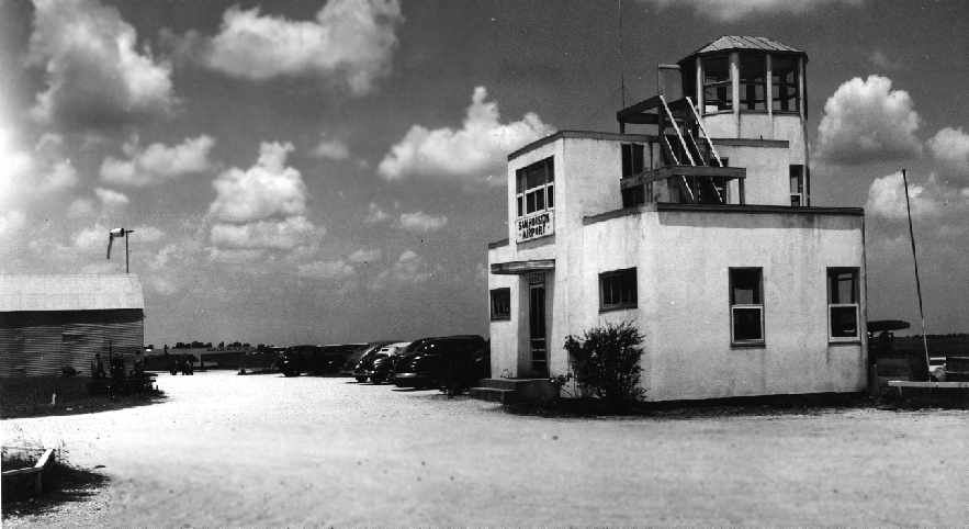
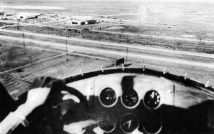
Sam Houston Airport was bounded by what would eventually be South Main, Chimney Rock, West Bellfort, and Hillcroft. Here's a 1950 image of a fellow approaching the airport, to the northwest, about to cross over main street.
there's an annoted version of the 1960 map to show where the runways and 'tower' had been, but it is hard to read because of the small file size.. The tripod site where these pics are from is very interesting, if you haven't seen it yet: http://tinyurl.com/k67ld
Yep, I'm the one that supplied some of that stuff. IE: the annoted pix, and the approach pix in the
old AG aircraft. That plane was built at that airport by Anderson Greenwood. They eventually got
into the valve, etc biz.. So I guess it would qualify as a Houston product..

I'd lived here since 1969 and didn't know that airport was there until a few months ago. I then
did a search and ran into that guys "abandoned airfield" site. He originally guessed Sam Houston
airport as being east of chimney rock. It was by using the old Westbury pix, and also street
maps, that I came to the conclusion it was really west of chimney rock. I sent him the info ,
and he updated the site with the new location. I'm curious... What makes you think the
airport buildings in that pix are close to Landsdown and Ludington? Is it something you see?
I was thinking those were of the buildings just off the entrance from south main, but am
not actually sure.. One reason that annoted pix is hard to read is because I compressed it quite a bit
to save file size. The original I have is much easier to read.
MK
-
MK, i enjoyed your post; some replies to some of your comments are below:
Dude, if you have that 1960 air photo of Westbury digitized, I would LOVE a copy. I'm an aficionado of the old neighborhood, big time..I have very few pics..
I finally got the full 1960 westbury pix up on my briefcase.. "30 megs of room I get to post junk.."
I won't try to link it to here, as the file is about 1.5 mb, and you really want to see it at it's full res
to get the best detail.
I've tried to date it from
looking at it, and as close as I can tell, I think it was
taken in winter of 1959-60. One reason is our house was supposed
to have been built in 1959, and I do remember the original
A/C permit saying 1959, but I forget what month. In this
picture, our house looks to be done. Another clue is the
shadows, and angle. The picture was taken in the morning,
maybe 9-10 AM ??, and from the angle of the sun from the
east, I would judge winter. The sun is coming more from the
southern hemisphere, where as in the summer, the sun is
more from the due east, or even slightly north position.
So... My guess is winter 1959-60..
It's possible it could be W 60-61, but being they hadn't started
Westbury high yet, I'm leaning to W 59-60... Westbury high was
done in either 61 or 62 if I remember right.
Lots of interesting things..
Westbury Square, or any of the shopping center, bank, etc
is there yet, but it looks like they had just started laying
out the square. Westbury High is not there, but the watertower
is. Note the faint remnants of the old Sam Houston airport.
You can faintly see parts of the runway, and the entry road.
Domain Privee over on old main is still pretty intact as
it was, and you can still see the "star" out in the yard.
Note how it looks like Old Main used to go farther west across
the tracks.
Note.. No freeway.. Post Oak was still the main drag in at
that time. Note the property with trees, houses, roads,
etc n/e of where Meyer Park would be. Is that the old
Meyer place you all are talking about? I guess this is
how it used to look, if it is.. Quite a spread...
The Westbury Centerette at Bellfort/Chimneyrock seems to
be there.. Ditto for the U-totem building on Bellfort..
No jack in the box yet...:/ Remember that jack used to live
at Bellfort/Chimneyrock instead of Bellfort/Post Oak..
Used to be a Baskin Robbins, etc next to U-totem.. The
guy that used to live across the street ran a barber
shop there too.. The building now known as foodarama seems
to be there. The old bowling alley at Post Oak/willow seems
to be there. I think Post Oak Bar-B-Q also.. Actually, I
knew a guy that worked there in jr hi about 1970-71, and
even then , that place had been there like 30+ years
according to what the old owner had said.
So I guess it was there going way back to the prairie days..
Meyer Speedway is there. But no Hillcraft at that point..
They had just started building over the airport..
You can see S.Willow and Gasmer were both there, and they
are also old streets going back to at least the late 30's,
early 40's. They are shown on the 1942 planning map.
Note the prairie north of Johnston jr hi.. Would be houses
there soon. The bayou looks pretty full.. Might have rained
the night before..?? Note the racetrack looking thing near
Main and Hiram Clark..Wonder what that was.. Looks about the
same size as the running track at Johnston...
At that point, the double lane W.Bellfort ended at Mullins.
I know a couple of people that lived on Bellfort at that
point.. I showed him this picture and one had said that some
of the houses, included theirs, had been "model" homes when
that place started.
One still lives there. "The two lived next door to each other."
Note the almost utter lack of trees at all the new houses.
Ours was bare too. Of course, now the trees are quite tall,
and gives the place a lot different look from the air.
The building that held the old 7-11 at Belrose/Burdine
seems to be there. But no Texaco station across the street yet,
nor the Gulf station that would be next door, next to the yet
to be fire station. No apartments yet either..
The last to be built in that area would be the Westbury Square
town homes which would be built when I moved here in 69.
They had just started framing those out when we moved here
and were probably done in 1970 sometime. They were real nice
when they were first built. And it was all open. If you lived
in those townhouses, you could walk around the courtyard
sidewalks around to where it met with the square, and bingo,
you were in the square. Also, that was the route I took to
and from school everyday. Of course, now it's all fenced in,
with gates, etc.. The whole place is basically ruined from
what it used to be. Now it's no different than any other
run of the mill gated apt complex..
Back in the old days, living in the square, or even the townhomes
connecting it, was kinda like living in old Europe..
That was the whole idea from the beginning. Note the way
Village Inn was designed kind of like an old English pub..
Parker School is there, but not the pool yet..
Of course, Godwin and Godwin park were still open land,
and ditto for Anderson School, and Hager park. You can see
how they seemed to have left room for both of those, and
probably was planned into the sub from the beginning.
What I would really like to see is older pix of the same
area from say the 30's and 40's, early 50's.. I'm also looking
for more history of the ownership, etc of the land back then.
I assume most was for farming, rice fields, etc.. I'd like to
know fer instance exactly who owned the land I'm sitting on
back in the old days.. Was it part of a large spread, or maybe
a smaller tract.. Only the shadow, and maybe the courthouse,
archives, etc know fer sure..
I haven't bothered going to any of those yet..
BTW, I hope the word wrap doesn't go flaky on me, and roll my
lines 300 miles long. Some of this I prewrote before I got
online, and just pasted it in..
Oh yea, the url is...
http://briefcase.wt.net/cgi-perl/ListConte...=public&id=
and the file name is "westbury60.jpg". I wish I could just direct link it without
having to go to the menu, but I'd have to put it on my web server, and
there ain't enuff room for it... They only give me a chinchy 5 mb for my
website..
 I can barely run a usable website with that..
 If anyone wants to post it from another site, be my guest.. I got it
from the westbury civic club website... I tried to find it on there,
but couldn't ...I guess they don't have it anymore, or I couldn't
find it... I checked all their old archives... The page seemed to be
gone..
MK
-
MK, i enjoyed your post; some replies to some of your comments are below:
Dude, if you have that 1960 air photo of Westbury digitized, I would LOVE a copy. I'm an aficionado of the old neighborhood, big time..I have very few pics..
I'll put it up on my briefcase server later. It's much bigger than the small sample that
has the Sam Houston Airport area. I had clipped that pix from the larger one.
The actual picture covers from east of Post Oak, west to about Hillcroft, all the way north
past Braes bayou.
Yep, since you were born in 56, I am three years older than you. You were going into Johnston Jr. High as I was going into Westbury High. Too, I spent 9th grade at fondren, so I started meeting more Braeburn Valley people at that point, and didn't hang at Westbury quite so much. I started playing gigs in 9th grade, and pretty much roamed Houston at large after that. The band director at Fondren was a lady named Ms. White, and Randy May was the well known drummer there, so much so that they once had a drum contest in his honor, while he was still a student. He went on to invent an internal miking system and some other innovative marching band equipment that has sold very well for Pearl. A student of Joe Raynor, he played his butt off. (probably still does.) Lives in Huntington Beach.
Randy May kinda rings a bell, but I didn't really know him..
So MK: you were a drummer at Johnston? Was a guy named Perkins was still the band director?
I guess he left before I got there. When I was there, it was Mr. Mueller <sp> ?.
At Westbury, I'm getting a vapor lock of the brain, but I think it was Mr. Munson,
or something like that. ??
From what I have heard, he is still alive, and still playing.. I was in band at Johnston with at least 10 drummers, but I can't remember many of them. Mark Keener was one of the better ones..I remember Marty Knoll now too, now that you mentioned him, and there was a guy behind me, on Belrose maybe, named Doug Landry, whose dad also played professionally..they had a blue sparkle Slingerland kit that I still remember watching them take apart and clean one day.
I think I remember that Doug Landry. And I went to school with a Doug Landry, but maybe a different
one. At Johnston, I ran cross country, and a Doug Landry was one of our runners..
You are right. There were a lot of musicians in the Southwest part of town back then. Quite a few kept playing. Houston was a great place to grow up a musician in the 60's and early 70's. Gigs and bands everywhere in those days.
I studied with Jack Dudney back then, a big band drummer who played with the Ed Gerlach orchestra, and then after 3 or 4 years, with Hap Fulghum, who lived in Bellaire and played with the Houston Symphony. (his son, Joel Fulghum, apparently is a top drummer down there nowadays. Haven't met him.) At one point Jack and Hap had a drum teaching studio together, right across West Bellfort from Westbury Square.
Yep, I knew of him, and knew his sons real well. Went to school with one of them.. One of his other
sons that I knew played geetar. Danged if I can remember their names now.. Seems one
was a Jack, "jr?", but forgot the other ones name.. The older one was in the same grade I
was, and in some of my classes. But I never took lessons from his dad.. Used to walk past
his shop all the time, as it was around the corner, pretty close to where the old record and tapes
was.. I took private lessons when I first started in 4th grade, "Merriam KS.", but never took
private lessons during jr.high or high school.. I moved here from KS in Nov 69, and was in
the 7th grade.
Two more points. As for Dan Mitchell, the owner of Mr. Fantasy, I heard from Pierce he married a girl named DeeDee George from Braeburn Valley, and that he is living happily ever after somewhere in the Houston area. And as for Trudy Hilton, i never saw her after 6th grade, so I don't know whether she was the girl that lived at Westbury Square, but in 6th grade, she was indeed pretty, with wavy blonde hair..I don't remember her too well, other than that. TRUDY? YOU OUT THERE? Write us..[God, I love the Web]Was it you?
Might have been.. She did have blond hair. I'm about 75% sure it was probably her, and
the name is real close, and I'm almost positive the last name was Hilton. And her age
would have been about right too. She was a bit older than me.. Actually, I think I used to
know her younger brother, but not for sure if he was from the right Hiltons. She was a hottie
though.. Kinda like a model.. Swiveled heads about everywhere she went. If she was born
about 1953, that would make her about 20-21 in 73-74 when I worked there. Pretty close..
I was only 16-17 at that time.
MK
-
Hummmm, I can't believe I've never seen that place, being I'm
close by.. I'm kinda confused on the location though.. This sounds like a
good place to take my metal detector..
NE corner? Seems that would be kind of near the old Fluor <sp>? building... I'm confused..
I would like to check it out though.. Maybe I saw it years ago,
but forgot about it.. I'd like to check it out.
MK
-
1
-
-
Please forgive the length of this post..
You guys are bringing back incredible memories. I found this forum searching "Westbury Square", hoping for a nostalgic look at the square. We moved in August 1957 onto Arboles Dr., fourth house from Atwell, five minutes walk from the square. I was four. We lived across the street from Candy Thackeray and her parents, Carolyn and Charlie, and the Hineses lived next door to them. On the corner of Atwell and Arboles was an accountant named George Fleet, who lived there with his wife Grace and their two kids Georgie and Cynthia. I remember a girl my age on Atwell named Mary Lippa. Heaven only knows what happened to all these people. The parents would be dead by now, but the kids would still be around somewhere, in their 50's and 60's.
................................................................................
.....
You were pretty close.. We were about 2-3 blocks away on Burdine. I remember the Hines I think,
but the others don't ring a bell. But I think you are a bit older.. I was born in 56.. So we
knew different people. I went to Johnston and Westbury..
We got there when it was brand new; in fact, the whole neighborhood was brand new. Houses under construction were everywhere. The square had just been constructed, but little of what is now standing had been put up yet except the one remaining corridor, which only is about a 5th of the whole thing. I remember the arch [that is standing] when it was being built a couple of years later, because we used to jump off the top of the building into the construction sand piles.
................................................................................
....................................
I've got a good air photo of Westbury taken in about 1960 or so.. Our house was just built.
The square wasn't there yet, but they were starting on it. Westbury Hi wasn't there yet,
but the watertower was... Johnston and Parker were both there, and pretty much new..
As kids, from about 1959 on, we were constantly on and around the square. We RULED that place on our Schwinn Sting Rays in the early 60's ; times were soo different..We roamed the candle shop, Mario's Italian retaurant, Rumpleheimer's, the bookstore across from it, the Gay Dot party shop [back when 'gay' meant 'happy, festive'], Cargo Houston, etc. The merchants would bring everything outside once or twice a year and have a big outdoor sale. The square was packed, full of life.
................................................................................
..........................................
I bet you got those Schwinns over there at that place at Braeswood and Hillcroft... :/
We used to ride our bikes over there and drool over the latest offerings..
Ditto for Westbury Yamaha's little mini bikes, etc.. They sold a little small 50cc
mini motorcycle that was the rage at that time... Course, I could never afford one myself...
West Bellfort only went a little past Hillcroft and ended in a huge field. It didn't go through to Fondren. I too remember the ruins of the monorail at fondren and main. West Airport went to Hillcroft and turned into a dirt road, but you could get through to Fondren there if you zigzagged a bit. We would walk that way to main street, just past fondren, and get fireworks, and have firework "battles" in Christman tree forts between the houses between Christmas and New years day; no one ever complained..
................................................................................
.......................................................................
Yep, when I moved here in 69, W.Bellfort pretty much ended at Hillcroft, except for like a
cruddy single lane or something.. At that point , they were in the process of extending it,
and it was soon finished..
The pool that is now at Ludington and Chimney Rock was then a complex of 5 pools, called the Westbury swim club, and you had to be a member to swim there.
................................................................................
.....................................................
I guess you mean the pool that is at the apartments.. Yep, I vaguely remember that thing
being a pool club way back.. I'd kinda forgotten about that. Back in jr.hi, I delivered
the chronicle to those apartments, and also the Westbury Square apartments on the east
side of Chimney Rock.. Used to ride a "stingray" bike with those bulky chronicle bags loaded
to the brim... Used to roll them at a shack behind the old Monterray House... Btw, they
also had some good bike trails behind Monterray House..
At this point, none of the curved building that would house Mr.Fantasy and all the apartments behind there [on the southwest and southeast side of the fountain]had been built yet. That was all just a big open field, out to chimney rock, although the parking lot adjacent to Burdine was there. Cargo Houston was there too, but the rest was not up yet. After a short time there was a series of little booths that the merchants would use during the outdoor sales. On the other side of Rumpleheimer's, the area that one of you mentioned where we'd all ride bikes, little dirt trails, was there right up until the end, just as it had been in the beginning.
................................................................................
............................................................
Yep, jumped many a hill there... I remember one time I jumped a hill, and my front
tire fell off while I was in mid air... Spike!!! Ouch...
I think that is where they had planned the lake.. on the other side of it was what is now the dollar store; then it was a supermarket, and an ice cream shop was on the corner of that building too. The bank looks exactly the same. The barber shop is still there (!!!) whoa..Although it faced the other direction, it was all the same to us, part of the square in a way.
................................................................................
...............................................
Yep, I've been going to that bank before most of the people that work there ever
thought about the place.. Probably before some were born.... :/
They had a German polka band a few times in the evenings, by the fountain, back in 61-62 or thereabouts, and this is where I got close to my first drum set player. Watched him all night. Became one, later.. Thanks dude, whoever you were..
I played drums all through school.. Bit then I switched to geetar in 1977...
People lived in the apartments above the shops, and I remember one time that someone had a heart attack and died, and fell over the edge, landing on the sidewalk below. They closed off that little section for a couple of hours. That happened in the corridor that is still standing.
................................................................................
......................................
Ouch...
Mr. Fantasy , the clothes store, was run by a guy named Dan Mitchell who had been the drummer for the Moving Sidewalks, Billy Gibbons' pre-ZZ Top band, and my friend Monty Pierce used to work there. This was when the pizza parlor had bands, and there was a furniture shop where the arch is still standing, run by George Martin and his dad. They used to live above the shop and build the furniture right there on the spot.
................................................................................
................................................................
Dang, I remember those people... I never knew Mitchell was the drummer for the sidewalks though..
I do seem to remember him being pretty "hip" at the time, for lack of a better description...
The guy that ran the Evolution tapes and records was kinda the same way.. Young, lots of money,
chicks hanging around, drove corvettes half the time... yada, yada... We always thought he
was a pretty hip cat back when we were just jr. hi bike riders... Wonder where he is now...
There were quite a bit of drummers, musicians, around Westbury.. There was a guy that
lived around the corner named Marty Knoll that used to play quite a bit.. When I was in the
Westbury marching band, I remember him once marching with us in the Foleys Parade as
an alumni drummer... He was going to U.H at that time I think.. Either that or Rice..
I remember a few times where we "all the drummers" would all march around the streets of Westbury
practicing up for the Thanksgiving days parade, or whatever.. VERY LOUD!!!!
When I went to Johnston, one of my fellow drummers was none other than Wayne Dolcefino...
Yep... *that* ch 13 Wayne Dolcefino... I still remember us sitting on the back drum row, and shooting
spit wads at the heads of all in front of us.. I often see him on TV and wonder if he remembers
that... :/
MK
Hummmmm. Trudy Hilton... Was she a hottie?
In a previous post, I had mentioned a deluxe
hottie that used to live above Al-Betos, near
the fountain. She was a blond hottie deluxe..
I could almost swear her name was Trudy Hilton.
I was thinking her last name was Hilton when I
thought about that in the other post... And Trudy
seems about right as a first name.. Small world,
or I'm confused...
MK
-
Back in the old days Stella was it's own town. I guess it and "Stella Junction"
are about the same thing. I've got a 1895 Texas map, and Stella is
marked as a town, along with the others in that area. IE: arcola,
juliff, etc, etc.. On that map, all the "roads" are actually the
rail tracks. Stella was at the point where the n/s tracks that run appx
along 288/521 intersect with the Southern tracks that connected Harrisburg
and Richmond, etc.. Being I don't see the n/s tracks that ran parallel
to Stella link road in the 1895 map, I assume they must have been built
a bit later. Those are the same tracks that run through Memorial Park,
and then south. They seem to call the intersection east of main, "West
Junction". It's interesting comparing the old 1895 map with all railroads,
and say a later highway map. The highways obviously followed the RR tracks
in most cases. I notice that the 1955 map calls the Holmes/Knight intersection
as "Pierce Junction". Another weird thing is on the 1952 map, they show a
town listed at Main/Chimney Rock. "Lotus, TX". But in the 1955 map, they
show that as "Heackers, and just east of Fondren as "Nichols" . They show
dot markers as if these were actual towns.. Kinda weird..
I cropped the Houston area on the 1895 map with the railroads, and the
1938 map, with highways. Note that Westheimer was once it's own town too..
They show the Sam Houston airport on that 1938 map.


MK
-
Actually, South Main went UNDER the railroad tracks when I was around there in the 50's-60's...at least one set of the tracks...I think the straight part.
Yep, I think it was that way a good while into at least the 70's. I remember
if you were going north on main, you went around that curve, that was kinda
underground, with sort of a "cliff" on the east side of the road. I forgot when
they built the elevated southbound part, but it was there in the early 70's.
MK
-
This cutting from a 1950 Houston Street Map sheds a little more light on the history of Old Main Street.
Hummm. Kinda interesting. You can see in the old 1950 picture that Craighead once ran south
and seemed to connect with Holmes rd. I was looking at some of the sat pix of that street,
and you can still see a few places where the really old sections still exist to an extent. Most
are starting to be covered with grass, etc.. I remember even in the 70's, I always thought that
that street, area must be pretty old. I guess I was right, even though I didn't know anything
about the history of the street. Another old area that is nearby is the gasmer/willow streets
a bit to the west. I had always thought those streets must have been pretty old too, as I
remember houses that were abandanded even in the 70's. I had this confirmed a while back
when looking at the 1942 map of Houston. Those streets were in place even going back to
the 30's I think, being the map itself was drawn in the 30's. I guess that area was really out
in the boonies at that time. The old Sam Houston airport was just to the west at that time.
Note Kirby running south to Holmes...I don't remember that being like that now, but I'd
have to check a recent map..
MK
-
Several days ago I happen to drive by what used to be Westbury Square and almost did not recognize it. In fact I was a little surprised that any of it was still there. I got curious about what had become of it and found this forum in a web search.
The last time I saw the place was probably in the early 80s or late 70s.
I pretty much lived at the square in the 70's. I worked there, and when I wasn't
working , I was usually partying there... :/ I remember in the the late 60's, early
70's, the square was hopping. On fri-sat nights, Village Inn would be packed, and
usually had bands. People wondered all over the place. We used to party out on the
big hill at the far end of the east parking lot. They had a sidewalk that ran along it,
and then a big hill that was on the land between the parking lot, and chimney rock.
I still live in Westbury too, and have been here since nov 69. So I still remember
weingartens, dugens?rexall drugstore, firestone, brittains broiler burger, etc..
I sorta knew Ira Berne, the owner of the square. Also his wife.. They were my
bosses landlord.. I worked at Al-betos, and then later also worked at Bull n Anchor
for a while. The shell of what was B n A is still there when you turn in to home despot
from W. Bellfort.. Being as I used to work there, I also had the run of the alley that
ran through the middle, and serviced the shops.. It was off limits to the general
public. If you pulled into the alley, Al-betos was all the way at the end. I could look
out the back door and see all the way down the alley. Westbury and it's party hearty
residents were well known across the USA at that time. Even high times magazine
did a story where they called Westbury, "Wastebury". In the mid 70's when I went
to Westbury Hi, it was not unlike that movie "fast times at ridgemont high". Quite
similar actually... :/ I knew people that were just like "Spicoli", or whatever his
name was... Same look, same behavior, and yes, they actually surfed at surfside..
MK
-
Yep, in this photo it's at the far right:
You can see al-beto's mexican resturant at the left edge of the fountain.
I worked there when I was in high school. Those are pictures taken when
the square was pretty new. They later did away with all the shrubs and plants,
and paved the whole shebang... Just to the right of al -betos is a door that leads
to apartments upstairs. Back when I worked there, they had a *really* hot
girl that lived up there.. I mean a hottie deluxe...
She used to come down and eat on the weekends. Everyone that worked at the resturant used to drool
every time she came in. We had quite a partying crew there.. I could tell a
few hundred stories... I remember when we worked there, after we got off
work at night, we used to prowl the town and visit all the places they talk
about on these forums... Like blue light cemetary, some weird "hollow" place
in river oaks, etc.. I remember going to some place in river oaks, but 30+ years
later, danged if I can remember much of the details.. I just seem to remember
"hollow" being part of the name. At that time, I was 16-17. Drove a 65 impala with a
396. One of the other guys drove a chevelle with a 396. Another drove a big
boat chrysler with a 383.. We all used to race on the freeways all the time
after work.
Back then, you could hit 120 mph + fairly easy, cuz the traffic was light at
night. We used to do 100 plus all the way across town. We never got stopped..
Lucky I guess...
MK
-
I'm not quite following you. Can you specify where this old 'Domain Privie' gambling house was, specifically?
Kevin
http://maps.yahoo.com/beta/index.php#maxp=...=29.65722&mag=1
Sorry bout the long link... Anyway, if you look at the sat pix, the "A" arrow will be pointing
at the intersection of Craighead, and Old Main loop. You can see old main running ne/sw..
Ok, see the "dividing line where the neighborhood with houses switches to cleared land?
The line runs exactly n/s. That line is about the midpoint of that section of old main.
On the southside of old main, that dividing line was the west boundery of the gambling
joint. There are still curb markers at the point of the entrance, but they are not showing
very well in that pix. That would be just east of the driveways to what I think is pro-mark.
There is a clump of trees pretty near where the old house, etc used to be.
I see there are new buildings, street just south of where the gambling place was. Thats
brand new.. Wasn't in the last sat pix I saw of that area, just a few months ago.. Note
the fresh white concrete... I had been to that place a few times in the 70's. Went in
the old big house, and also saw the swimming pool, etc, which was off in another
building. It was pretty ramshackle even then... He left in the early to mid 50's when
they had a local gambling crackdown. Went to Vegas and started the Sands.. Think
it was the Sands anyway... BTW... Note the lawn sculpting in that overhead pix...
Big diamond with a circle in it, and the big star east of the driveway. In the 70's,
we drove through on that same driveway, and you could loop the place and come
back out. But in the 70's, it was real overgrown and thick. Not like the sculpted lawn
you see in that pix. Now, in 2006, it's all mowed pretty clean again... :/
MK
-
I'm not totally sure, but from what I've heard, the foundations
near the bayou are from camp logan.. I think barracks, or '
whatever... They had a hospital, etc, but seems it was more
towards the area of the golf course.
MK
-
ooh! i like it!
not to stray even more off topic...but
reminds me of this book i have (how to repair small appliances, circa 1961):

album cover? yes?

There is still one section of old main that is still pretty well used.
It runs from appx craighead?, to nearly main street, but I'd have
to check a map to see how it hooks up. This is the section of old
main that the old Jake Freedman "Domain Privie" gambling house
used to be. He was Caroline Farbs grandfather BTW...
It's torn down now, and all that land is fenced field now.
There are still a few people living around that area, and the pro-
mark drumstick company is about at that location. I remember
in the 70's, there was also a regular house on the same side
of old main as the gambling joint, but farther east, closer to
main. But it's gone now... I drove by there a few months ago.
So...Whoever bought all that land, must have probably bought
out the whole block and fenced it up.. That land is probably worth
buckoo bucks.. I wanted to metal detect at the old gambling site,
but it's all totally fenced, and the land has been bulldozed over
I think. Makes me wonder if the old swimming pool at that joint is
still under the ground... :/
Band names... I came up with one a while back while I was chatting
about the common use of "superglue" to mend and seal cuts in the
fingers of geetar players.. As an example SRV was an avid superglue
user when he got cuts in his fingers... I thought... Hummmm..
Sounds like Finger Bondo... They said.... Hummmm... Good name for
a band. I can see the marquee now... Modern Appliances, featuring
guest star, Finger Bondo... :/
MK
-
Used to go to the weinersnitzle near Bissonet and Hillcroft.. Gone now..
As far as a few close by.. Westbury Square had a few that are all closed
now. You had Village Inn Pizza, Bull n Anchor, Al Betos, Rumpleheimers,
and maybe some I forgot about. The buildings for Village Inn and
Bull n Anchor still stand. Bull n anchor was in the old run down shell of
a building to your right, when you turn into Home Depot from W. Bellfort.
Al Betos and Rumpleheimers, which were both near the fountain, were both
torn down to make room for the Home Depot. I think Al Beto's would be
about on the far back corner where they now sell lumber, etc.. :/
I once worked at Al Betos's, I was the daytime manager when I was
about 16 or 17.. Also worked at Bull n Anchor for a while later on..
I imagine that the owner of Al Beto's , "Gilbert Villasana<sp>?" is now dead. I
haven't heard from him in years. Mike Shields used to be the owner
of Bull n Anchor... No tellin what happened to him... The building that held
Village Inn has been sitting unused for years, but is still there..
Dang...I forgot about China Cottage...It was next to B&A, and I think
it's basic building still stands too... China Cottage was the last of those
resturants I actually ate at.. I used to do their refrigeration, walk in cooler,
etc work until they closed down.. All those places had pretty good grub..
MK
-
Now that we have DVDs, do you think that movie theatres will eventually die a natural death?
They already have as far as I'm concerned. But cable and VCR's started all
that.. I haven't been in a theater is so long, I forgot the last time.
But I was a taping fool with the VCR's, "have a few hundred movies taped",
and am quickly falling in line with the DVD age, being I now have a burner.
I'm burning movies nearly every day, and naturally get better quality with the
DVD's than the old VHS tapes. I just recorded and burned to DVD "the shining"
tonight as an example. I was just at fry's this evening getting another 100 pack
of DVD's and the matching jeweled cases.. I burn a lot of video...
I get near HDTV quality if I watch them on my puter. I use a 21 inch monitor, and
run my res at 1600x1200. You can't hardly see the pixels at all. I go back to a
regular TV, and the pixels stick out so much that it's like a dot matrix puzzle..
I'll probably get a true HDTV TV card pretty soon. They are getting pretty
cheap. I'm using a ATI-9800pro all in wonder right now.. I edit the video before
I burn em, so cut out all the commercials etc.. You can colllect a heck of a lot of
movies just off cable TV, if you have the time to waste... :/ I've got a "sima goDVD"
video stabilizer that I use for macrovision foiling..
MK
-
"Jones"....
Wonder if that was an old ad for Jones Apothocary...Kinda looks like their
old sign vaguely...
MK
-
I writ....
I remember in the
latel 60's, 70's, you could hear the cars at the speedway every friday night,
even here at the house, which is near westbury square.
Actually, thinking about it, I think it was every saturday night... Been so
long, I pert near fergot... But I think the noise on fri was usually the bands
marching at butler at football games. Sat was race car night... I myself
was in the westbury marching band, and played drums. So I added to
the racket on some of those fri nights in the 70's...
MK
-
Meyer Speedway used to be out there as well--near Hillcroft & S. Main..I don't know what year the bulldozer ate it. How about Navarro Courts?
I'm not sure about Meyer speedway. I guess it was about the middle to late 70's
when they shut it down. Yep, was at the corner of Hillcroft/blue ridge and main.
Butler stadium is just to the east on the same side of the street. The old Sam
Houston airport entrance was across the street from Butler stadium. The old
main street airport was farther uptown just south of OST if I remember right.
Both of those airports are now covered by houses... I remember in the
latel 60's, 70's, you could hear the cars at the speedway every friday night,
even here at the house, which is near westbury square.
They even ran a nascar championship race at meyer I think about 1974 or
somewhere along there... I think Bobby Allison >sp?> won if I remember right.
MK
-
Man--I remember the Mitchell Inn..kinda resembled a Holiday Inn (somewhat smaller "Great Sign")..is it completely gone now?
Not sure...I drive past there all the time, but never really pay much
attention. I know at least one of the older motels is still there, but
can't remember which one it was. It's on the west side of the street
south of OST I think. I remember when I moved here there was
another motel right about at main and the loop. But danged if I
can remember the name of it offhand... It may well be torn down now,
but I never really paid that much attention. It was on the west side
of the street, a bit south of sonny looks. Like I say, I think it was
almost at the loop 610 corner, on the west side... I'll think of the
name one of these days... I stayed there a full week in 1969.
What is wild is to look at the surroundings in some of those pix.
Like open prairie.... The 10,000 block of main was nearly out in
the sticks in the old days. Once upon a time, there was an airport
on main between what is now hillcroft, and chimney rock. "Sam Houston".
That was really out in the sticks... There was also another main street
airport a bit closer to town, fairly close to where the loop is.
I don't remember that holiday inn...Must have been gone when we moved
here. That car in the pix looks like a 50's chevy.. maybe a 56...
I was going through pictures at one of the archive sites, and was looking
at all the pictures of the fancy houses that were once on main near the
downtown area. Lots, and lots of them... That street has changed a lot since
1900.
MK


Westbury High School At 11911 Chimney Rock Rd.
in Other Houston Neighborhoods
Posted
Yep, Pepper was there when I was. He might have been
principle at that time though. I remember Rivers Lodge,
and also a new Asst. Washington if I remember right..
I forgot who was the head principle out of that bunch..
It was either Lodge, or Pepper. I don't have a yearbook to
double check..
MK